-2")
ENSO state in limbo as La Nina struggles
Much fuss has been made over the past several months in regards to the development of La Nina this year, coming on the heels of one of the strongest El Nino’s on record. There is a propensity for these things to occur, after all, and a significant cooling of Nino-region pacific temperatures led many to believe that a La Nina was not only on its way — but could be moderate or strong by the time cold season arrived in the Northern Hemisphere. Those ideas will not come to fruition.
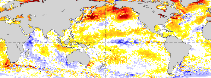
The lack of La Nina development has, instead, been notable — with a significant lack of depth to any cooler sea surface temperature anomalies. Trade winds aren’t cooperating (we’ll get into that more later) and tropical forcing seems to favor this pattern continuing through the next few months. It appears likely, now, that La Nina will never truly get off the ground. Forecast models have responded, with monthly and seasonal data now pointing to a Neutral (La Nada) pattern through at least the first half of North America’s calendar Winter.
Lets start with a little bit of background. During last year’s El Nino, which was well documented as one of the strongest ever, trade winds in the Equatorial Pacific were significantly weakened. This process allowed warm water to pool near Australia and then shift eastward. Those very same trade winds strengthened over the summer months (intermittently), pushing that very same warm water back to the west. This allowed cooler, subsurface water to upwell toward the surface.
Climatology favors trade winds remaining a persistent feature. In other words, we are supposed to have east to west trade winds blowing warm water toward Australia and keeping cooler water situated near Peru. It takes a significant feedback to reverse this process — and that exact reversal is what allows a La Nina to develop. That process has yet to remain established this year, and accordingly, the cooling of sea surface temperature anomalies in the equatorial pacific has not been suffice.
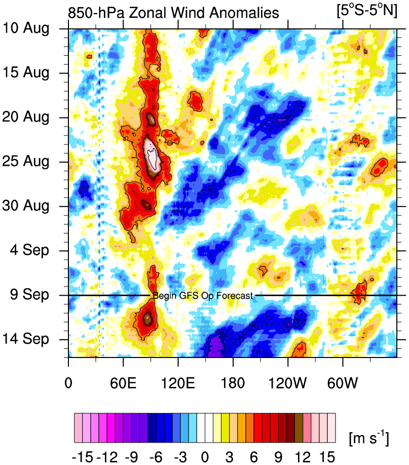
850mb wind anomalies do a good job of showing inconsistencies in trade winds throughout the equatorial pacific.
The ups and downs — namely, the inconsistencies — of this process have been observed for several months. As El Nino faded away in April and May, trade winds surged. This allowed for a rather significant cold pool of water to form at the subsurface throughout the equatorial pacific. Some of this water eventually upwelled toward the surface — aiding in the going forecasts for La Nina to develop consistently through Fall. But those trade winds suddenly halted in June. This was inhibitive to La Nina’s development. Trade winds again increased in June, only to decrease again in July.
By and large, La Nina’s circulation and feedback process struggled to develop this summer. Trade winds were much too inconsistent — far too much so for any persistent equilibrium change toward La Nina in the equatorial Pacific.
Most other global circulation indicators are falling into line, as well. The SOI (Southern Oscillation Index) is based on the difference between air pressures over Tahiti and Darwin, Australia. Sustained values below (more negative than) -7.0 indicate El Nino conditions, while sustained values above +7.0 indicate La Nina conditions. This is because since Tahiti is east of Darwin, and air generally flows from high to low pressure, a higher pressure in Tahiti (a positive SOI) would lead to more east to west wind flow (towards Darwin), which is an indicator of stronger trade winds. Since July, the SOI has remained in “neutral” indicative positioning. The latest 30-day Southern Oscillation Index value from BOM came in at +4.9 — well within Neutral ENSO range. In fact, even after a recent rise towards values over 5, the SOI dipped again back to its current position.
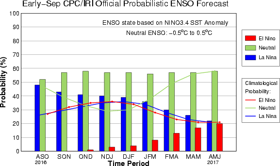
The latest ENSO probability forecasts from multiple sources show a shrinking probability of any sustainable La Nina.
Over the next six months, the future of La Nina seems now to be in significant doubt. Intermittent trade wind busts won’t suffice to help develop the circulation. And while a brief increase in probability of La Nina conditions is modeled through the DJF trimonthly period, the growing consensus is that the equatorial Pacific’s equilibrium will slide back toward its natural neutral state.
Forecast models are in growing agreement that neutral conditions will be the dominant phase throughout the winter. What exactly does this mean for winter forecasts? In short, it suggests that other wild cards will come into play — much differently than last year, when the record El Nino was the driving force behind the global circulations. This year, instead, the QBO and PDO states may have significant impacts on the hemispheric weather pattern (posts on both of them soon).
Stay tuned over the next few weeks for further updates on the state of ENSO and how it will affect the Winter of 2016-2017.
Our DJF (Winter) 2016-2017 ENSO Probability Update (9/9/2016)
El Nino: 0%
Neutral: 75%
La Nina: 25%