-2")
Pattern in transition as December quickly approaches
Over the past few weeks, much has been made in regards to a changing hemispheric pattern. Global circulations are in flux, and a much warmer than normal pattern has in fact changed across the Continental United States. However, the changes have been slightly less stout and slightly delayed when compared with initial ideas, and the atmospheric pattern has been left in an overall flux as we head towards December.
The Thanksgiving holiday is often an important time-frame in meteorology as one looks ahead to the upcoming winter. Gone are the days of wild speculation and assumption when it comes to the winter ahead. December is just a week away — and the ideas formulated regarding the pattern as we move into winters first month are beginning to obtain more weight. Some ideas are clearly losing steam, while others garner more attention.
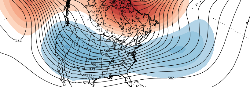
It is often prudent to conduct a full reassessment of the hemispheric pattern in the stratosphere and troposphere at this time. There are several key features throughout the stratosphere and troposphere that are currently controlling the pattern across the globe — and have especially significant interest for those of us in the United States. These have all been highlighted on the image below which separates the major global features into 4.
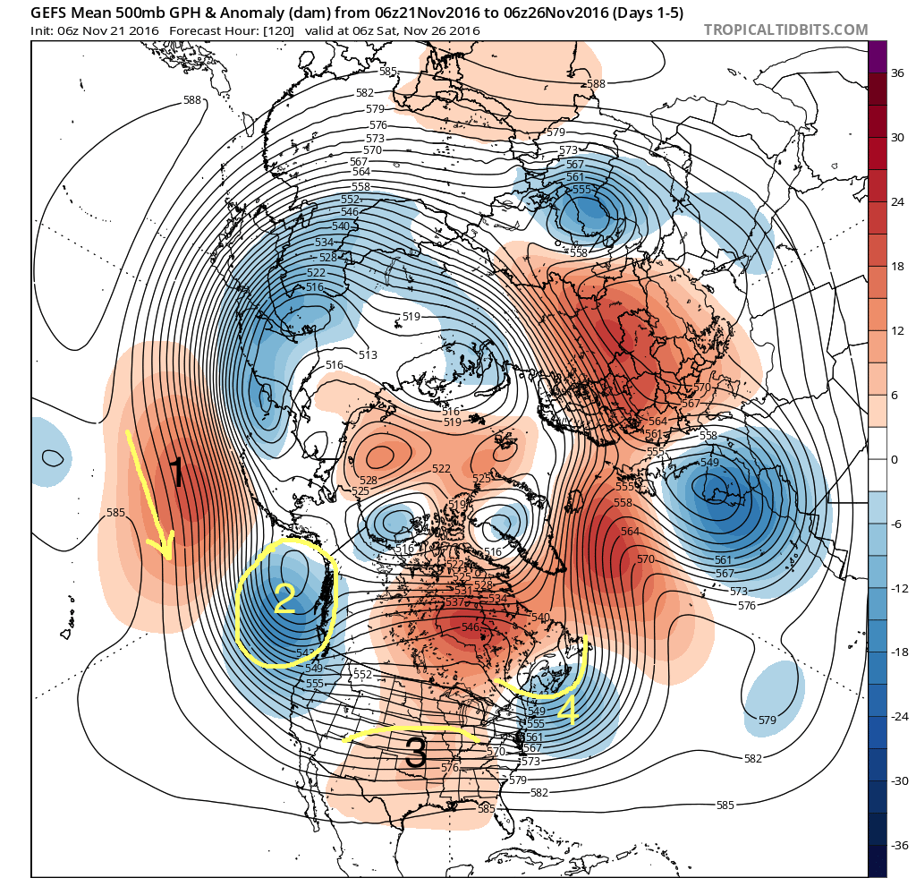
1) The Pacific Jet
The Pacific Jet stream has become a significant, dominant feature — probably the most impactful weather feature on the globe — over the past 3 to 4 weeks. Its above average strength and reach has had major implications on the downstream weather pattern. The Pacific Jet does several things to the pattern across the United States: It keeps the pattern progressive with multiple strong disturbances, it tends to bring Pacific, maritime air into the country, and it stops the flow of any true arctic air.
All three of these “reactions” have been observed over the past few weeks as a wintry pattern has had significant difficulties becoming established. In addition, an active train of disturbances — all generally warmer with maritime air involved — has moved through the United States.
2) Gulf of Alaska Vortex
A large trough, or vortex, has become established in the Gulf of Alaska over the past two to three weeks. This persistent feature has also become quite important and a controlling feature of the weather pattern across the United States. This vortex aids in the development of troughing which pushes into the Western United States.
Most notably, however, to the east of this vortex, higher heights are generally supported. This helps to develop a ridge over the Central United States, which when combined with the aforementioned Pacific Jet leads to warmer, maritime air moving into the Central US.
3) Central United States Ridge
The result of the previous two noted features, a Central US ridge has become a noteworthy and established feature on average over the past few weeks. Maritime air from the Pacific has surged eastward, and been enhanced in its movement by the Gulf of Alaska Ridge. This has allowed a warm ridge to develop into the Central US.
While undergoing various fluxes and intensities, the ridge has resulted in above to much above normal temperatures overall during the month of November throughout a large majority of the United States.
4) Northeast US/North Atlantic Trough
This feature has become well established over the past several weeks, especially with the steadily increasing amount of ridges over the higher latitudes. This has led to temperatures averaging closer to normal throughout the Northeast US, particularly coastal locations and New England.
Where does the pattern go from here?
Forecast model guidance continues to indicate an accelerating shift in the hemispheric pattern. In fact, detailed analysis of the hemispheric pattern features, on average, over the next several days and weeks shows a significant change when compared with the pattern which had become established throughout the month of November.
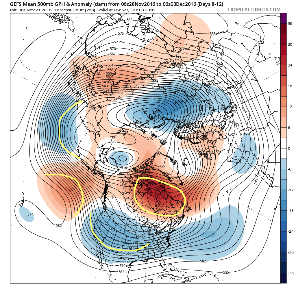
The retrogression of the pattern, which we discussed as a likely occurrence in our Winter Forecast released last week, appears likely to transpire as we move into December. This leads to a few major pattern changes and will result in significant differences across the United States.
Notably, the Pacific Jet weakens slightly to allow a large ridge to develop towards the Gulf of Alaska. This is nearly opposite to the pattern currently in this entire area of the Eastern Pacific. A trough becomes situated near the Aleutian Islands during this time, helping to develop storm systems further northward into British Columbia.
Troughing then develops southward across the Southwest, Central and Eastern United States. High latitude blocking appears likely to become established gradually across Canada and parts of the Davis Straight, which could lead to colder than normal air being displaced southward from this areas.
Exactly how this pattern transpires will be the key to sensible weather results across the United States. For example, the intensity of the blocking will have a significant impact on how storms behave and interact with cold air.
One thing, however, is for sure: Major pattern features are shifting and changing, and the effects will be felt as we head into what appears to be a cooler than normal and active month of December.