The return of cold and unreliability of forecast models
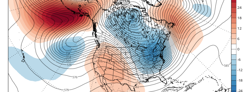
So far this month, Central Park is running two degrees below average as a result of an impressive North Pacific wave-breaking event that shifted the cold from Siberia into North America and the US. The cold has since generally retreated northward as a result of an expanding Pacific Jet that collapsed the ridge in Alaska and brought a Pacific airmass into the US. Additionally, the stratospheric Polar Vortex strengthened again, which further bottles cold air northward. However, these Pacific wave-breaking events tend to repeat themselves, especially when it’s already been established that there is a wave-train of ridges and troughs in the Pacific rather than a purely zonal flow. And while the cold air is bottled northward, it is still on our side of the globe, so any shift back to cold can theoretically occur quicker.
Starting around late next week, we’ll see the first in a series of wave-breaking ridges enter the North Pacific as the Pacific Jet retracts and slows down. This will allow the “train” to come to a halt and thus allow this ridge to build somewhat poleward, while the wave train to the west continues. However, there is still not enough to necessarily sustain this ridge, especially considering the extremely low heights from the Polar Vortex. This is when we will need more atmospheric “help” via a jolt to the Polar Vortex from both Scandinavia and another wave-breaking event in the Pacific on the heels of the first one. This should occur in early January and help to sustain -EPO ridging. The video below explains this process.
Basically what happens is that the initial massive -WPO ridge that cuts off and tries to go into the EPO region is then reinforced/constructively interfered with another wave-breaking event east of Asia that will then turn the whole NE Pacific into a massive ridge. The NE Pacific part of the Pacific wave train “wave breaks” so it cuts off and slows down into a massive ridge, but the Pacific further west continues its train, so the ridge further west continues churning on until it “runs into” our first NE Pacific ridge. You then get constructive interference and thus even more ridging. This is the idea of a wave 2 event being followed up by another wave 2 precursor that gives more legs to a true -EPO block that can last. Hopefully for cold and snow purposes, it happens this way and the -EPO can actually gain some more longitude.
Some guidance has hinted that the ridging either stays relatively far west and as a result there would be a Southeast ridge. Additionally, some guidance has been inconsistent on the duration of the EPO ridge as well. But considering the magnitude of the wave-breaking process and the fact that guidance is severely mishandling the latest MJO pulse (the video also explains this), there is plenty of credence to the idea that not only will the EPO ridge last long, but it will also build poleward and somewhat east as well. It may not build east enough to truly combat the Southeast ridge, but it should shunt it enough so that a colder and snowier pattern can settle in for the Eastern half of the US starting sometime in early January.

