-2")
Active and Wet Pattern to Return Middle of Next Week and Beyond
Good afternoon, everyone! We hope you are enjoying this lovely Friday. For more information on the general day-to-day weather including the slight chance of strong thunderstorms on Easter evening, please refer to the main dashboard or the AM Zones Article. This article is going to be focused on the pattern moving forward.
After a winter with really not much in the way of high-latitude blocking, that has changed in March and to some extent this month. While it has not been a 100% constant, it has been persistent, and after a brief break, will return next week and help shunt an active Pacific Jet a bit further south. This initially further south position of the Pacific Jet will allow storms to traverse the country a bit further south than usual for this time of year, which should be southward enough to give us synoptic forcing for heavy rain.
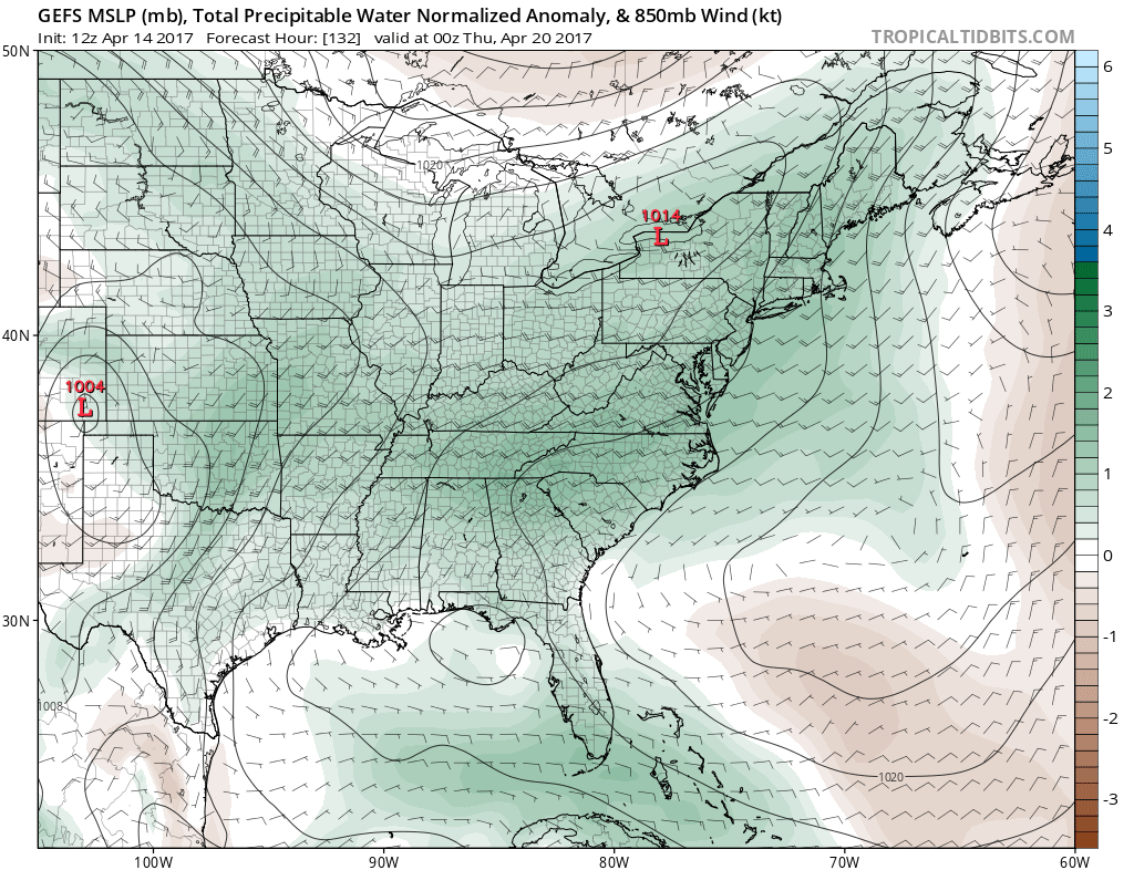
Today’s GEFS valid for the latter part of next week shows a trough digging into the western US with a strong gradient out ahead of it, leading to an active pattern for rain (Tropical Tidbits).
Notice the high-latitude blocking in the NE Pacific and how expansive it is. This, combined with a large block in the Northern Atlantic both act to somewhat suppress the Polar Vortex in Central Canada. There is also a large vortex that sits well underneath the massive NE Pacific block, a good indicator of an active Pacific Jet which is suppressed south, and further suppressed south by the aforementioned blocking and the PV position.
The PV in Central Canada as well as ridging out ahead of the trough in the W US leads to a strong gradient from the Tennessee Valley into the Northeast. Notice how this tight gradient is oriented from SW to NE, from the Gulf into our area. Also notice the extremely expansive positive precipitable water anomalies — an indicator of the high amounts of moisture available in a large area to potentially trigger rainfall. This, combined with the storm in the W US will serve as a highway for plenty of moisture to advect into the region, perhaps in multiple impulses.
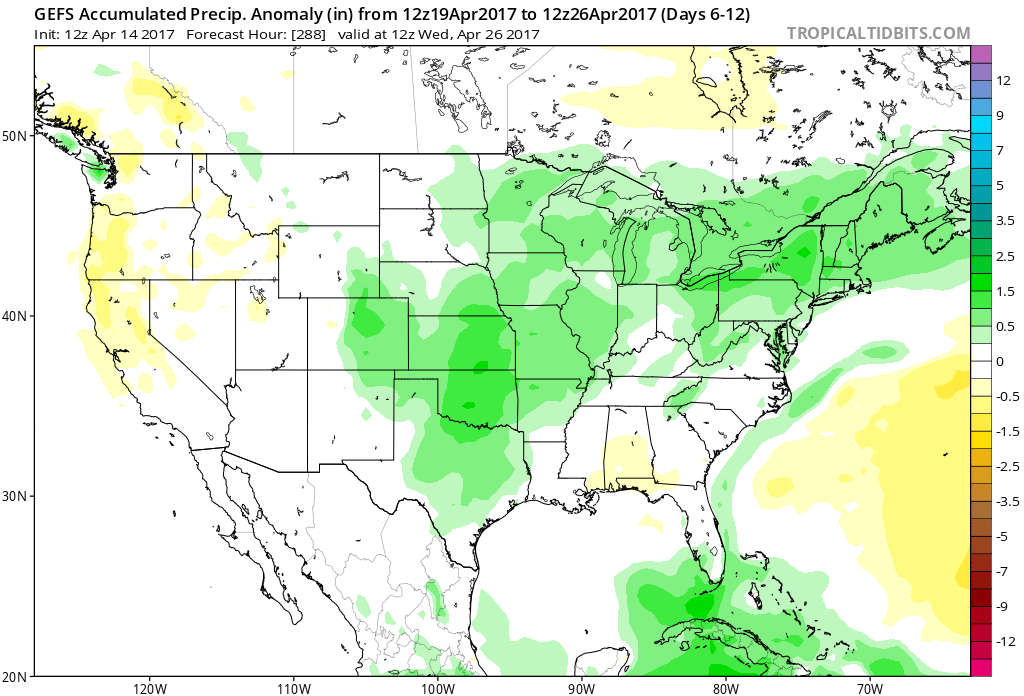
The 7-day GEFS precipitation anomaly from April 19th through April 26th shows positive anomalies for much of the area, an indicator of a potential active week for rainfall (Tropical Tidbits).
The 7-day precipitation anomaly chart from the GEFS tells the story well. It shows plenty of rainfall in the Southern Plains directly ahead of the storms as they dig into the W US, and then the anomalies spread northeast on top of the Southeast Ridge as the storms then head northeast from there. The fact that the Pacific Jet was pushed south to begin with allows these storms to tap into the Gulf for moisture, rather than the storms and most of the forcing generally staying in Canada. This also allows us to get in closer proximity to these storms for true synoptic lift, rather than more convective lift which is less reliable for widespread precipitation.
It’s hard to focus on any one individual storm right now given the lead time, but the idea of multiple storms giving us rain has merit. Multiple pieces of energy will break off from the Pacific Jet in the middle of next week.
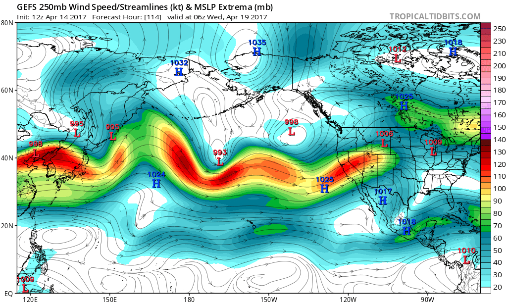
Today’s GEFS valid for the middle of next week shows the Pacific Jet setting up for an active pattern (Tropical Tidbits).
The above image is valid for early on the morning of the 19th, which is right when we expect the active period to begin. We can see a very expansive Pacific Jet that crashes into the Western US, which provides plenty of moisture and disturbances. Notice also how the jet splits and weakens closer to our area — but a northern piece has broken off into a relatively strong confluent jet in SE Canada. This jet provides a nice right-entrance lifting zone for our area out ahead of the main jet to the west — so the 19th-20th could be the first time period to watch for rain.
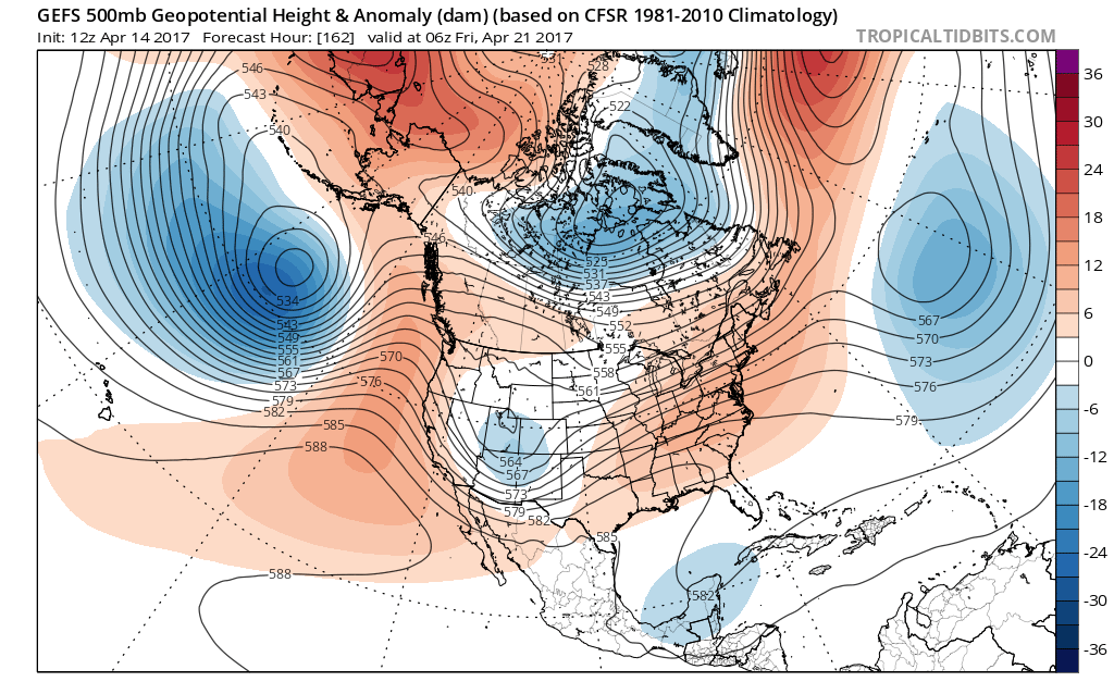
The speed of the jet would argue that after another couple of days, we could see another threat of rain. The biggest threat of rain may be in the 23rd-26th period as the entire jet finally buckles, but not after having already providing plenty of moisture and a strong gradient pattern. Thus, the pattern could end with one giant cutoff low in the Southern US providing multiple days of tropical rains that ride up the coast and hit our region.
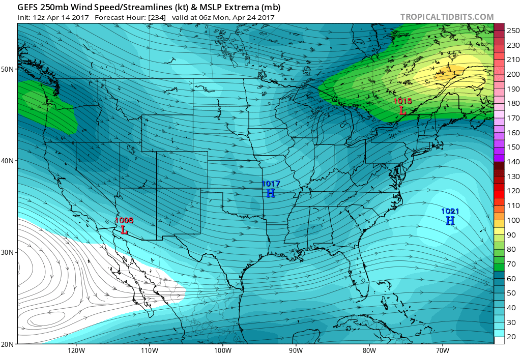
The GEFS valid for April 24th shows a rounded, curved broad jet digging into the South Central US, allowing plenty of moisture to surge out ahead of it (Tropical Tidbits).
The above image could be the big rainy “end” to the pattern, as the Pacific Jet buckles into one large broad trough in the South Central US on April 24th. This would force a large highway of moisture from the Gulf and into the area — look at the orientation of the streamlines. Also notice again the presence of a confluent jet in Northern New England — another right entrance region source for upper-level divergence and thus upward vertical motion.
This is the 24-hour precip on the ensemble mean that results:
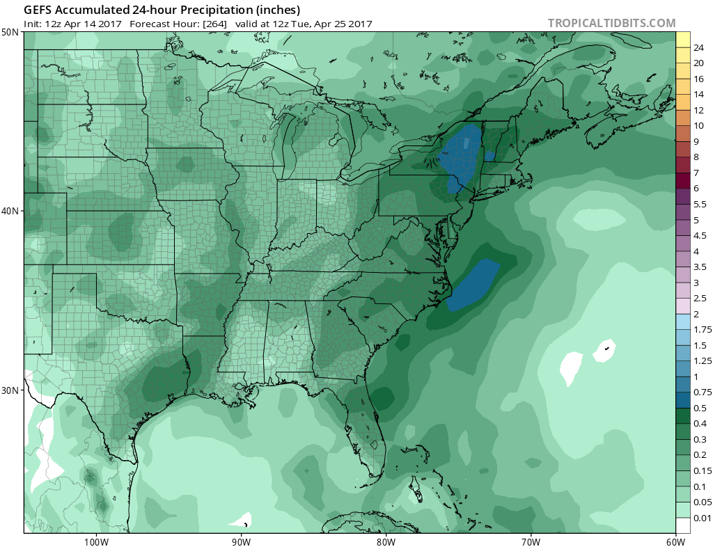
Today’s GEFS 24-hour precip valid from April 24th – 25th shows a very strong signal for heavy rain in our region (Tropical Tidbits).
This is an extremely strong signal for heavy rain to fall during this time. The strongest signal for the rain is still just northwest of the area, as there is the chance that there may be a bit too much ridging out ahead of the South Central trough to place us in the bullseye for heavy rain. But regardless, it’s still a strong signal for multiple periods of rain in the 19th through 26th period of this month, with the heaviest “finale” being possible in the 23rd – 26th period, give or take.