-2")
Premium Long Range: A Look at the Western Hemispheric Pattern and Tropics in August
Late last week, we saw our second heat wave of the summer over many parts of the Northeast and Mid-Atlantic region. It may have appeared to some people, that may be we have turned the tide toward more hot and humid pattern for the rest of the summer. But this pattern much cooler and unsettled this week. Now there are increasing indications from several climate phenomena and long-range ensemble guidance of major pattern change now occurring over the Pacific Basin, that will support a cooler pattern, for the Northeast and Mid-Atlantic regions, at least the first couple weeks of August.
Overall Pattern
On the long-range ensemble guidance, the atmospheric pattern changes start out in the Pacific. A large trough will be over parts Southeast Asia and Western Pacific and in turn support a ridge near or just south of the Aleutian Islands and a large trough or upper-level low over more of the Gulf of Alaska and Northeast Pacific. This North Pacific pattern overall will continue to support more profound heat ridge in parts of the Western and Central US. More ridging over Greenland/Davis Strait will also result in a more negative NAO pattern. This entire pattern throughout the Western Hemisphere will on average support deeper troughiness in the Great Lakes and Ohio Valley and stronger Western Atlantic ridge to build over next couple weeks. But we do know ensembles and weeklies in general in the super long-ranges are less reliable. So what climate phenomena is potentially influence this pattern?
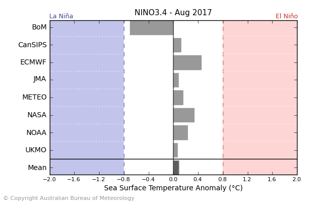
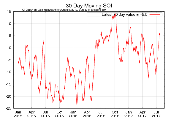
Well, currently it appears ENSO is neutral strictly by definition; using the sea-surface temperature anomalies and the 90-day moving SOI values. Latest model forecasts also suggest sea-surface anomalies in the ENSO regions of the tropical Pacific, will remain in neutral state. More easterly zonal winds near the dateline and rising 30-day moving SOI values into the positive territory, suggest a more weak La Nina-like tropical forcing pattern will predominate, during at least the first couple of weeks of August.
Currently for this last full week of July, convection and tropical forcing has been over the Maritime Continent (Southeast Asia/Indonesia or phase 5). Based on the 500mb of the MJO in this phase during July in past years, it doesn’t seem incoincidental that the pattern this week, resembles that composite. Basically the North Pacific pattern consists of more a trough over Western Pacific ridging over the Aleutians with a trough over the Northwest US and Western Canada. Then some ridging more over Northern Plains, troughiness over the Eastern US and more -NAO blocking over Greenland. A byproduct of this atmosphere pattern evolution this week, will be a quite significant coastal storm or Nor’easter with heavy rainfall, gusty winds, and potential for some flash, river, and coastal flooding for the Mid-Atlantic region Friday and this weekend.
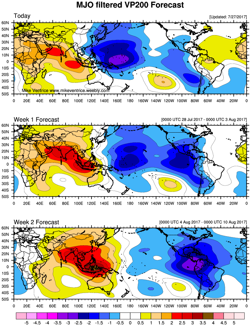
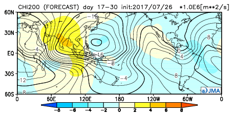
200mb velocity potential anomalies indicate tropical forcing will be shifting the Western Hemisphere during the first couple weeks of August
Then the long-range model and ensemble guidance suggest convection and tropical forcing will be transitioning into the Western Hemisphere during the first couple weeks of August. This tropical forcing in general will likely support a more profound ridging with more sustained, extreme heat and dry conditions continuing over much of the Rockies and Western AG belt and with troughiness with more periods of cooler and wetter weather over Eastern AG belt, Northeast and Mid-Atlantic regions. During the later half of August, tropical forcing on average into the Western Pacific/Maritime Continent and also between the Western Hemisphere and Africa. This may support more zonal heights over the CONUS and some temperatures to moderate closer or somewhat average over Northeast and Mid-Atlantic during the last two weeks of month.
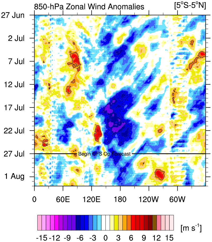
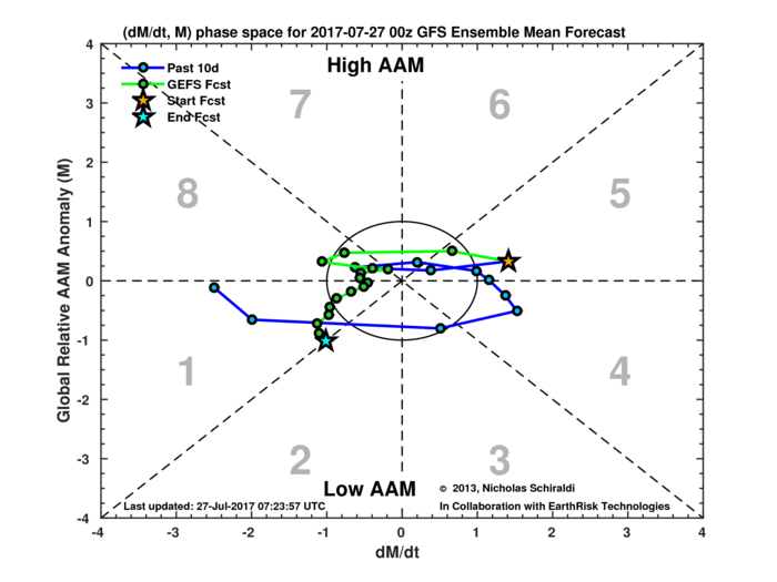
In our premium long-range article, at the end of June, we also discussed about the easterly zonal winds with the QBO descending from 10mb to 30mb and 50mb and how this will affect the MJO. Well the latest monthly QBO (value for June at 30mb -3.18, which is big drop from +8.01 in May. Latest indications show the AAM (Atmosphere Angular Momentum) will also be more negative phase. Research as shown that the AAM and OBO in negative phase has tendency to modulate MJO activity and NAO pattern. Convection and tropical forcing with MJO propagate into the Western Hemisphere and Africa or phases 7, 8 and 1. The NAO is in a more neutral to negative phase during the summer. By the way, if the QBO persists in the negative phase, along with lower solar activity could have major implications for more high-latitude blocking for this winter as well.
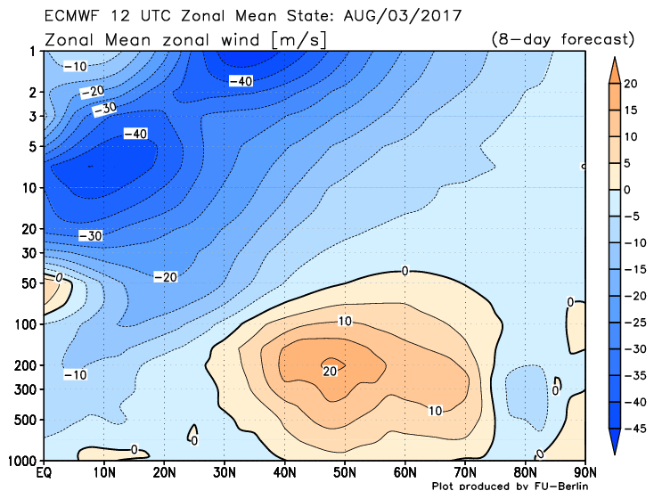
Easterly zonal winds (shaded in blue) continue to descend to through 10 and 30m in August
But right now, we will focus on the rest of this summer. Below is what we generally expect for going for the Northeast and Mid-Atlantic regions for much of August perhaps into September. Then deeper look into the tropics. More forecast thoughts for the rest of CONUS during the August into September will be in the new long-range outlook for consulting/AG clients over the next few days.
Temperatures
Overall a moderately warm pattern with temperatures running near to several degrees below normal is expected to continue over the Northeast and Mid-Atlantic regions into the first couple of weeks of August. Any surges of heat and humidity are likely to relativity short-lived over the region. Then there is a possibility that a confluent flow may develop between troughiness over Southeast Canada and a more ridging over the Southern United States. This could result in high pressure positioned north and east of the region, supporting Canadian maritime airmass with an onshore winds or backdoor cold front coming from New England or a frontal boundary stalling to the south.
Towards the mid-month, as the tropical forcing wanes over Western Hemisphere, heights may become more zonal more over CONUS. Thus temperatures may run near to several above average, over Northeast and Mid-Atlantic for later in the month. But there is lower confidence in pattern evolution during the later half of August. Particularly, as the -QBO may still support more episodes of -NAO blocking.
Precipitation
Despite periods of a negative NAO or high-latitude blocking, this pattern will likely continue to be somewhat active and progressive due to a faster La Nina-like northern pacific jet and shorter wavelengths in height fields typically during the summer. More troughs associated with storm systems coming out of the Pacific will be moving across the Northern Plains then dig on downside of ridging into the Great Lakes or the Ohio Valley. Some upper-level ridging with a low-level southwest flow will like support, a warmer, moist and unstable airmass.
As a result, more convective threats with some severe weather and/or heavy rainfall are possible for Northeast and Mid-Atlantic region. The exact nature of severe weather threat swill likely come to timing and the amount of kinematics such as shear and forcing. But the pattern will support less more EML (elevated mixed-layer) advection with mid-level NW flow, for higher-end severe weather events in the Northeast. So heavy rainfall and localized flooding will be likely be greater concerns during the middle to later part of August.
Tropics
The tropics in the East Pacific and eventually in the Atlantic may heat up with MJO moving into Western Hemisphere by in August. For last couple weeks of this month, more subsidence with the SAL (Saharan Dry Layer) or dust clouds from over Africa, has inhibited more development of tropical waves as move eastward over the Atlantic. A CCKW (Convectively-Coupled Kelvin Wave), forecast during to progress into Atlantic during the first couple weeks of August. This atmosphere feature could provide more favorable unstable and less sheared environment for another tropical system to form. Tropical Storm Don had form earlier in this month, as a weaker CCKW had move through the Atlantic. But the had subcomb to more hostile ennvironment with shear and dry air over the Caribbean Sea.
There may be lull activity during the middle of August. But then are indications from long-range JMA and CFS weeklies that there may two areas of significant convection and tropical forcing over Western Pacific/Maritime Continent and between Western Hemisphere and Atlantic Basin. This will support a stronger subtropical ridge over much of the Atlantic.. Thus we there is possibility the for another more active period of tropical cyclones over Atlantic Basin during last couple week August and perhaps into September. This is also typical near the peak of hurricane season in Atlantic. So we are not seeing much going against at this time.
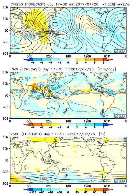
JMA weeklies showing CHI and rainfall convection wth more zonal heights over CONUS during the later half of August.
Nevertheless, there will likely be a break in the subtropical ridge over Eastern US, with the aforementioned overall pattern over Western Hemisphere, during the first couple week of August. This could cause troughs to dig deeper into the Gulf Coast region and support more tropical systems moving more northwest out of the Tropical Atlantic and/or Caribbean towards the Gulf Coast or Southeast United States. More profound upper-level subtropical ridge over the Western Atlantic will tend to support more strengthening of any tropical cyclones into perhaps a hurricane.
Any threats further up the East coast, including the Mid-Atlantic and Northeast region, will likely depend on the strength of the ridge over the Western Atlantic, the timing and positioning of troughiness and amount of any high-latitude blocking. A pattern that favors a hurricane to hit these regions is often much harder to predict and come by. But the prospects of more -NAO blocking periods appears to support more a little higher risk of at least a tropical system’s remnants affecting the region this year. We may see Western Hemisphere pattern continue to more tropical activity and threat to East Coast into September.
So as we enter into the final month of meteorological summer, it appears no prolonged heat waves are still in sight for the Northeast and Mid-Atlantic region. Alot of true extrme heat, will likely stay over Western Parts of United States. There is still the possibly the later half of August is still in up in the air, and we could see more summer-like warm and humid pattern return for while. But we may have to watch some for tropical systems to threaten the Gulf or East coasts by then. Stay tuned for more premium long range updates, over next few weeks, as we continue to analyze new data that comes in.