-2")
MJO and Recurving Typhoon Leads to Volatile Pattern
Good evening, friends! Over the past few days we have discussed, at length, an upcoming wholesale pattern change across North America. As changes in the Pacific Ocean fold down into the United States, a large and stagnant ridge over the Eastern United States will gradually become replaced with a trough, arcing from the Central States to the East through days 5-10. This will result in colder than normal temperatures expanding eastward from the Central United States. The duration and exact intensity of this cooler air remains in question, but what exactly is causing it to occur in the first place?
As we have discussed before, the pattern change comes initially from the retrogression of synoptic features over the Western Hemisphere and North Pacific. The polar vortex retrogrades out of Northern Canada and into the Bering Sea by early next week. That very same vortex phases with more energy over the North Pacific and results in a larger, deep trough positioned over the Aleutians. This pattern forces a ridge to build over the West Coast of the United States and Canada, and large mid-latitude trough to start digging into the Central and Eastern US during the middle of next week.
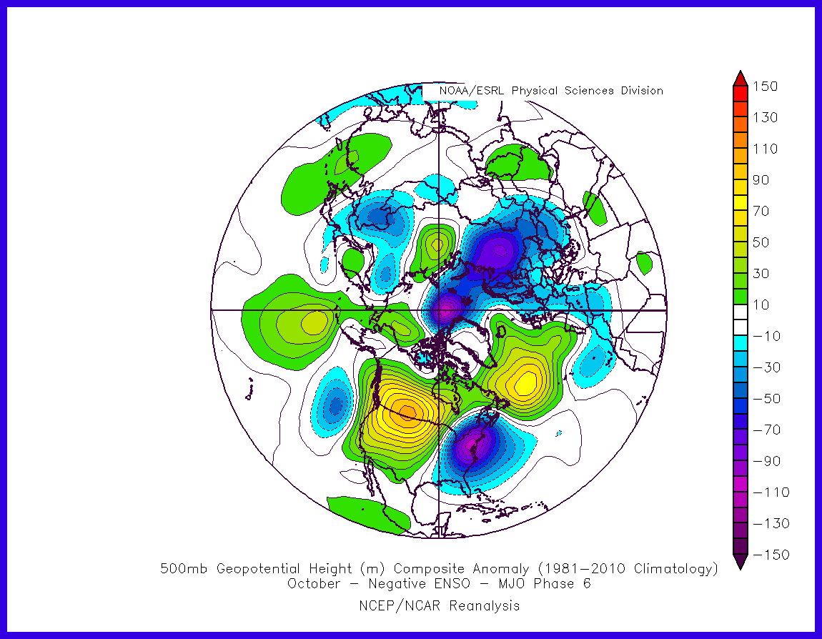
This new Pacific pattern over the next few weeks will also be enhanced and then guided by the MJO progression. Various model and ensemble guidance suggests a very amplified MJO in phase 5 eventually entering Phase 6 by next week. Since we already have some weak La Nina conditions in the atmosphere, based off the SOI values well into positive territory, we are using the 500mb height anomaly composite during negative ENSO phase for October.
This composite, which we showed in our previous article, shows a strong ridge over the Western US and a deep trough over the Eastern US. This is similar to what much of the model and ensemble guidance have been suggesting for next week. But also notice the anomalous ridge over the North Atlantic. Current guidance shows this ridge, but heights overall remain more transient over Greenland than the anomaly composite. So while we technically may have a -NAO, there isn’t true high-latitude blocking in this region before the trough reaches the east coast.
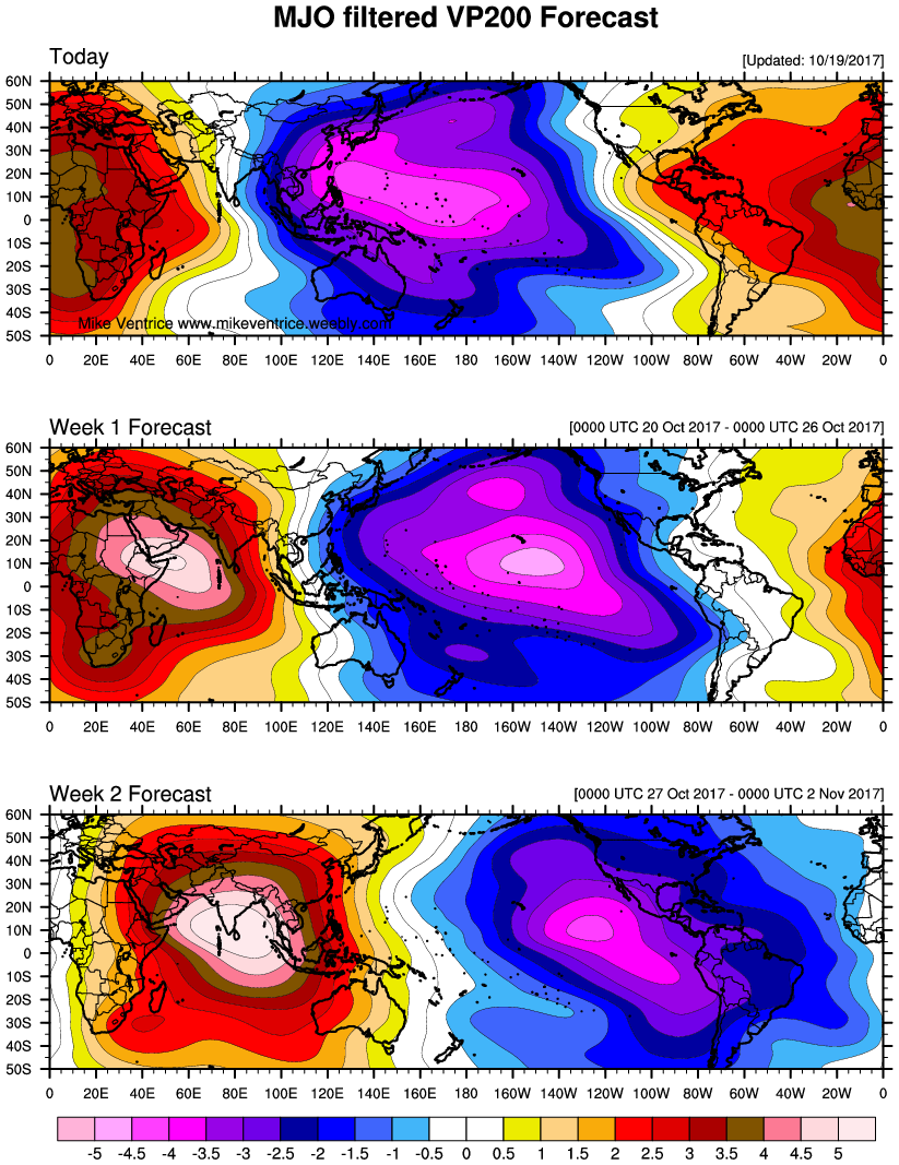
200mb velocity potential anomalies indicating tropical forcing associated with a strong MJO wave moving through the Pacific over the next two weeks (Image credit: Micheal Ventrice)
Models vary in regard to how the mid latitude trough will behave as it approaches the East Coast. A lack of high latitude blocking in the Atlantic may act to allow the Western USA ridge to roll eastward, resulting in a slow moving, large cut-off low over the Eastern States. This system would continue tap into sub-tropical moisture from the Gulf of Mexico or the Atlantic and could bring some heavy rainfall to parts of Eastern US during the middle part of next week. Cooler air moving in behind this system could serve to be short lived and weak.
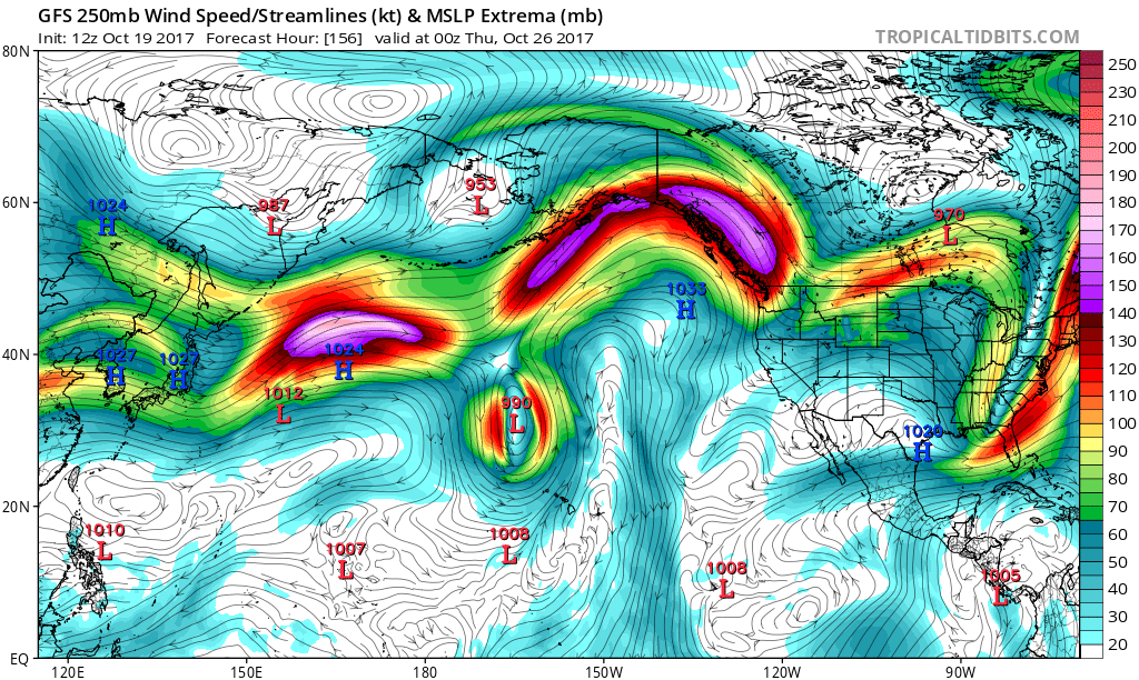
Another factor in this pattern is Typhoon Lan in the Western Pacific. Lan is actually a byproduct of MJO and tropical forcing over the maritimes and Western Pacific this week. Current models are forecasting this storm to become a very powerful typhoon over the next few days, then possibly threatening Japan, before recurving into the North Pacific next week. As Lan continues to intensify and tracks toward Japan, it causes more Rossby wave activity in the Pacific, which aids in a trough or surface low to develop toward the Aleutians during the early and middle part of next week. Thus the ridge amplifies again in the West coast of the United States and Canada, causing more shortwave energy to dig into the Northern Plains, supporting another shot of cooler than normal temperatures closer to the end of the month in the Central and Eastern USA.
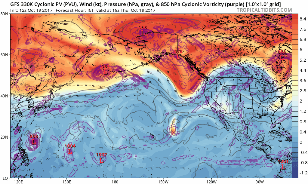
GFS model cyclonic vorticity forecast showing Rossby wave triggered by Typhoon Lan in the North Pacific and downstream effects over North America (Tropical Tidbits).
However, there are things to watch regarding the Typhoon being weaker than model forecasting suggests. If it’s weaker, the pattern will be not be as highly amplified or meridional as models suggest. The blocking signal in the Atlantic would also be much weaker, hence the pattern would likely more progressive. Lastly, there is some uncertainty with the MJO and ENSO influences going forward. Latest ECMWF model and ensemble guidance forecasts the MJO to weaken, as it propagates into phases 7/8/1 in November. However, the GFS model and ensembles forecast a stronger MJO moving through these phases, which results in a more amplified, blockier, and colder pattern — particularly in the northern third and central part of the US — as we enter November. Also with the MJO passage, we may see trade winds reversing over the tropical Pacific that may result in more neutral ENSO conditions. But if the MJO is weakening, it would have less influence on the atmospheric pattern. With a lack of high-latitude blocking over Atlantic, there is nothing to prevent the faster Pacific jet and warmer than normal temperatures from returning over much of the CONUS. The GFS is also known for overdoing MJO passages in phases 7, 8, and 1.
So we continue to favor more volatility in the pattern for late October and early November than we have seen recently. We have significant doubts on more prolonged cold, especially over the Eastern US. But we will continue to monitor the MJO, ENSO, and Typhoon Lan for any significant changes, as if the GFS guidance is more correct on these features, there could be more prolonged cold. Stay tuned for more extended and long range updates over the next few days. We will have our first outlook for entire month of November and another update on the La Nina for rest of the fall and winter months.