-2")
The importance of the EPO and upcoming cold risks
For some time now, we have discussed the likelihood that colder than normal air would be a common theme in the Northern and Eastern United States during the month of December. Like most things, it was not expected to be constant, but it was expected to be prevalent, and especially when compared to the past few December’s which featured nearly coast-to-coast anomalous warmth in the United States.
After a warm start, colder than normal air invaded the Great Lakes, Ohio Valley and Northeast during December’s second week. Winter weather threats have followed, with many areas recording multiple snowfalls. While this airmass hasn’t broken records, it has been just as anomalous as advertised, and has had an obvious impact on markets and businesses. After a brief period of moderation, forecast models are beginning to signal the return of arctic air into the USA – and this time it may be more anomalous than before.
One of the main culprits in our forecast, which has featured the likelihood of colder than normal air across the Northern 1/3 of the US during this upcoming time frame for some time now, is the presence of Eastern Pacific ridging, also known as a -EPO (East Pacific Oscillation) . Ridging that builds from the Pacific northward into Alaska and Arctic is historically very effective at dislodging arctic air southward into Canada, and then especially . The flow of cold in the atmospheres low levels often comes directly from polar regions, meaning very anomalous air masses can shift southward with ease.
Forecast models are beginning to suggest – after days of showing warmth – the development of this ridging, and a changing pattern in the Pacific Ocean that will support anomalous cold shifting into the USA during Christmas week and continuing through the end of the month of December. Much of these trends are just beginning, as forecast models begin to iron out details and work against biases that have caused them to show warmth for quite some time.
What does this mean, exactly? Think of it this way: If a forecast model initializes conditions wrong, or has a bias to handle a certain area of forcing wrong, the resulting forecast in the medium and long range will inherently be incorrect. The GFS and GEFS, for example, has a well known bias to poorly handle MJO waves – which directly impact circulations across the globe. It’s incorrect handling of the MJO (Madden/Julian Oscillation), is likely directly leading to its propensity to develop ridging in the Southeast US, leading to warmer forecasts and -GWHDD. On the other hand, the ECMWF have shown a better skill in handling the MJO wave and continues to propagate it into phases through phases 7 and 8 during the rest of month.
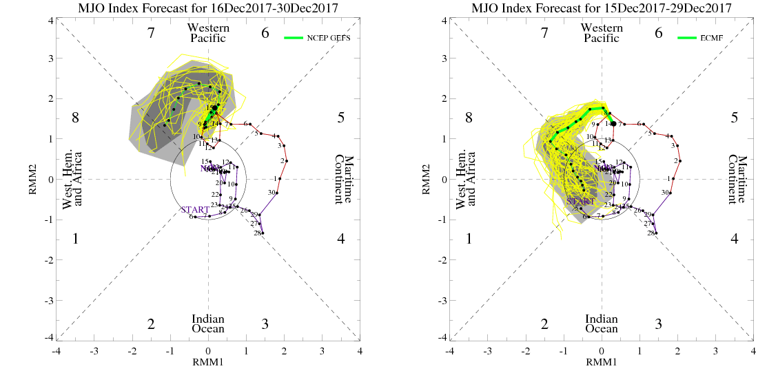
GEFS MJO forecast stronger in phase 7 on the right. While the ECMWF ensemble MJO forecast propagating into phase 8
While we believe the idea that a Southeast ridge will be appearing at some point, as the -EPO pattern evolves, we can confidently say that the GFS/GEFS model has likely been way overdone with its amplitude. This is likely largely because it shows the MJO propagating slower or stronger in phase 7, which supports a stronger Southeast ridge, for late December and likely way overdone with its -GWHDD forecast through the long range period, as well. Therefore, understanding how the atmosphere is behaving, we can accurately forecast moving forward without making big jumps on -GWHDD forecasts based on individual model runs.
Instead, here’s how we think things will shake down:
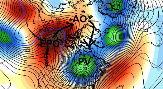
First, the EPO and AO (Arctic Oscillation) will shift into a more positive phase over the next several days, as high-latitude blocking relaxes and tropsphereic polar vortex reasserts itself further north over Canada or near Greenland. This will allow for more ridging over the USA with moderating temperatures, especially over Southern and Central regions of the country. But later next week, as the aforementioned Eastern Pacific Ridging or -EPO begins to reload and build into Arctic regions, we expect the pattern to change dramatically, as the tropsphereic polar vortex moves south into Hudson Bay or Southeast Canada. This will gradually allow for more arctic, deep cold air intrusions with lower heights and deeper troughs returning to much of the USA during the period between Christmas and New Years.
Second, as the ridge with the -EPO builds further over the Eastern Pacific, Pacific energy will have the opportunity to dig deeper into the Southwest or South-Central US. While disturbances will eject northeastward into the Central United States, the deep low level cold air flow over Canada will keep cold air entrenched across the United States. This will set the stage for potentially multiple winter storms — and confluence/high pressure over the Northern 1/3 of the United States will keep low level cold locked in underneath any ridging. This suggests that for some periods of time, mid level heights may be above normal, while low level temperatures will actually remain much below normal!
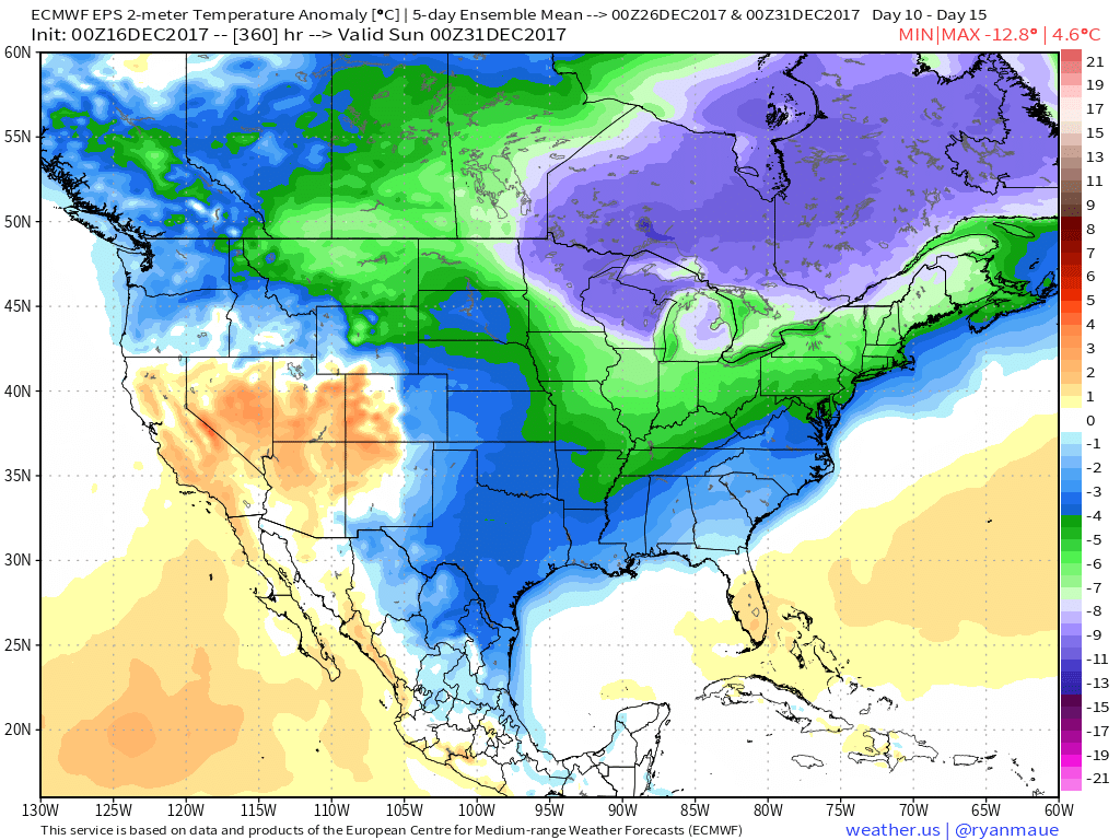
Latest ECMWF EPS showing 2 meter (surface) temperatures below normal with arctic cold air over much of the United States between Christmas and New Years.
We continue to believe that both the GFS and ECMWF model and ensemble suites are overdoing the strength of the Southeast ridge. On top of the aforementioned issues with the MJO and tropical forcing, both sets of guidance have shown an overemphasis on Southeast ridge leading to more prolonged warmer temperature anomalies over much of the Eastern US, in the past winters with a strong -EPO signal. If the MJO were to continue to propagate stronger through phase 8, it will increase the chances for high-latitude blocking over Greenland, exacerbating prolonged arctic cold over much of the Eastern US.
We anticipate this pattern, with cold and stormy risks over the USA, to continue to linger into first week of January especially from the Midwest to the Northeast states. A few days of moderation are possible here and there. But GWHDD numbers are likely to run higher than average through early January. Thereafter, the pattern will begin to undergo shifts as tropical forcing runs out of “time” and begins to shift towards a La Nina base state. As the MJO shifts out Phase 8 in Mid-January, the potential for widespread moderating temperatures across the USA is expected.
This article was written by John Homenuk and Miguel Pierre.