-2")
Dorian approaching Puerto Rico, heading toward Florida this weekend
Tropical Storm Dorian will approach Puerto Rico in the next 24 hours, possibly making landfall, before continuing toward the Bahamas and eventually Florida later this week. Dorian continues to battle dry air and wind shear today, with maximum sustained winds at 50 miles per hour as of the 5pm update from the National Hurricane Center.
The storm is tracking west-northwestward at 13 miles per hour. The systems center of low pressure reformed to the north earlier today, leading to an adjustment in the anticipated track in the next 24 to 48 hours. This change increases the likelihood of a landfalling Tropical Storm in Puerto Rico sometime on Wednesday.
Dorian is not overly strong at the moment. The system is surrounded by relatively dry air and moderate wind shear – both unfavorable for development or strengthening of tropical cyclones. Still, Dorian has been resistant so far with pulsing thunderstorm activity and a reformed low pressure center early today.
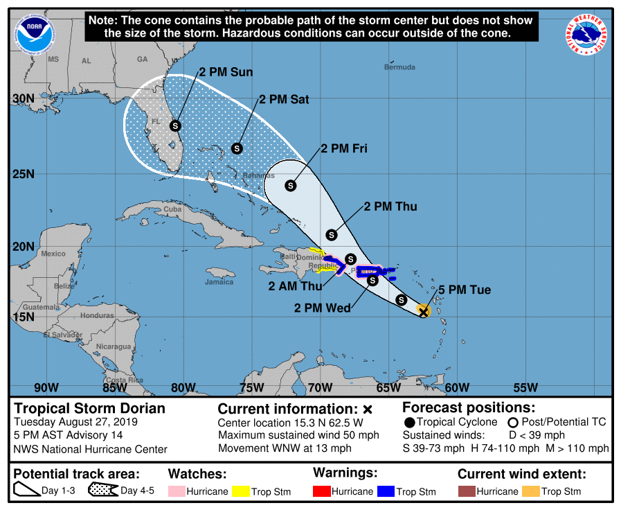
Forecast model guidance is in good agreement that the storm will head toward Puerto Rico on Wednesday, likely bringing heavy rainfall, gusty winds and high surf along the coastlines. Tropical Storm Warnings and Hurricane Watches have been issued by the National Hurricane Center for the entire Puerto Rico coastline, as well as the eastern coastline of the Dominican Republic, as the storm approaches and impacts that area from Wednesday into Thursday.
If you live in Puerto Rico:
- The worst of the storm will arrive on Wednesday and continue through Thursday morning.
- Dorian is nothing like Maria – it is a much weaker, smaller storm system.
- Heavy rainfall, gusty winds and some coastal flooding/surge can be anticipated.
- Review your tropical system emergency plans and have a plan in case you lose power, observe flooding, or see strong winds.
Trouble could be brewing in the Bahamas
Dorian is forecast to move toward the Bahamas later this week after she passes by Puerto Rico and the Dominican Republic. The environment will become more favorable for tropical development and intensification at that time. Still, it’s hard to know exactly how Dorian will look when it arrives there.
Wind shear and dry air – plus the landmasses of Puerto Rico and the Dominican Republic – could overwhelm the storm system on its approach to the Bahamas, leaving it ragged and unorganized. Or – in a more concerning scenario – the system could remain unfazed, approaching the Bahamas in a favorable position to strengthen quickly.

ECMWF Forecast Cones for Dorian (Allan Brammer) 
Ensemble Forecast Tracks for Dorian (Allan Brammer)
The latest forecast model guidance is suggestive of at least some strengthening of Dorian as it moves into the Bahamas. A ridge positioned to the north of the storm – over the US East Coast – is likely to steer the storm to the west, toward the Atlantic Coast of Florida by this weekend.
Currently, the National Hurricane Center is forecasting Dorian to landfall as a strong Tropical Storm on Florida’s east coast Sunday afternoon. However, it is worth reiterating that the intensity of the system is a major uncertainty at this time. The envelope of potential evolutions is still quite high.
Residents along the Southeast US Coast, but specifically the Atlantic Coast of Florida, should review tropical storm system preparedness and emergency plans. There is no need to panic, but it is time to review the steps and procedures necessary for preparation just in case.
The future of Dorian should become more clear in the next 24 hours, as the system passes Puerto Rico and remerges into the waters north of the Dominican Republic and Haiti.
Trackbacks & Pingbacks
3currencies
Leave a Reply
Want to join the discussion?Feel free to contribute!