-2")
Strong storms possible today, Dorian heads towards Southeast US Coast
The Storm Prediction Center has placed the NYC Metro Area in a Slight Risk for severe thunderstorms this afternoon. The main threats with any storms are expected to be strong wind gusts and heavy rain, but a few isolated tornadoes and small hail can’t be ruled out either.
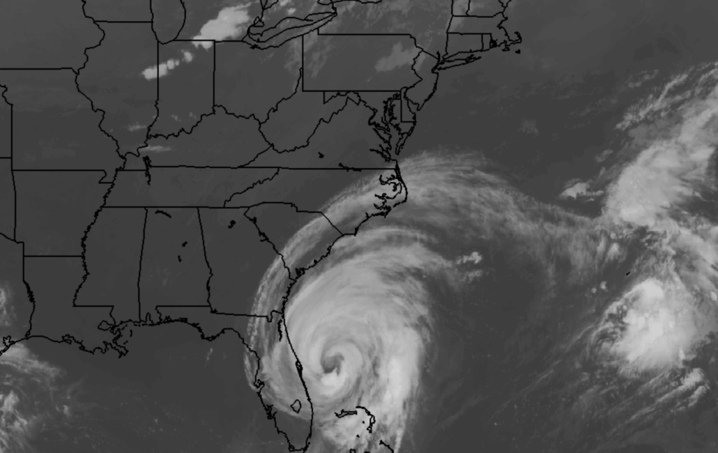
Meanwhile, Hurricane Dorian has gathered some steam once again and is heading northward as it parallels the east coast of Florida. The storm is expected to move northward towards the Georgia and South Carolina coast before turning north and northeastward. Significant impacts appear possible in coastal regions of Georgia, South Carolina and North Carolina later this week.
Technical Breakdown: Strong to severe storms possible today
Update 10:30am: Thunderstorm activity is expected again today, as a notable disturbance approaches from the northwest. As usual, the thunderstorm potential will arise from a delicate balance between instability, wind shear, and lift in the atmosphere. These are all essential ingredients for thunderstorm formation.
Later today, the atmosphere is expected to gradually become more unstable with daytime heating at the surface and some cooler air aloft. Meanwhile, a frontal boundary will move from Pennsylvania into New Jersey during the early afternoon. The aforementioned storm system approaching from the Northwest will bring a belt of favorable wind shear with it – on the order of 40 to 50 knots in the mid levels of the atmosphere.
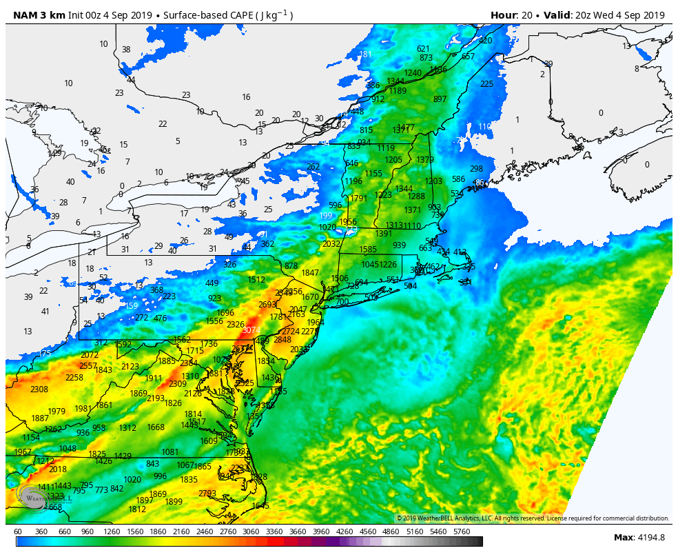
NAM model forecasting ample instability on Wednesday 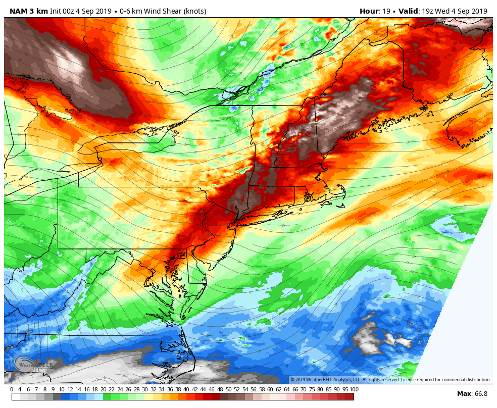
NAM model forecasting strong wind shear on Wednesday
If storms can form, they should be able to tap into the instability and wind shear to become organized. Some forecast model guidance suggests the potential for stronger winds aloft to be mixed down to the surface. We can visualize this using dCAPE (downdraft cape) on forecast soundings, to measure the momentum and downward transfer of winds that usually stay a few thousand feet above our heads.
Bottom Line: The potential exists for strong and severe thunderstorms during the early afternoon through the early evening, and some of them will be capable of producing strong wind gusts. Lightning, heavy rain and small hail will also be possible.
Dorian will bring a myriad of hazards to the Southeast US
Hurricane Dorian continues churning toward the Southeast US coast this morning. The storm is expected to make a very close approach to the Carolina coastline later this week. The wind field has expanded, and the storm has gathered up quite a significant storm surge. As a result, coastal areas of Georgia, South Carolina and North Carolina have been placed under both Hurricane and Storm Surge warnings from the National Hurricane Center.
In addition to wind and storm surge, the potential for torrential and flooding rainfall appears to be significant. The upper levels of the atmosphere will become more favorable for precipitation to expand away from the storms center, and surface convergence and lift could allow bands of torrential rain to sit over the same areas for many hours. The GFS and ECMWF ensemble means are both indicating the potential for more than 10″ of rain in less than 24 hours in parts of South Carolina.

HWRF model forecasting heavy rain from Dorian in South Carolina on Thursday 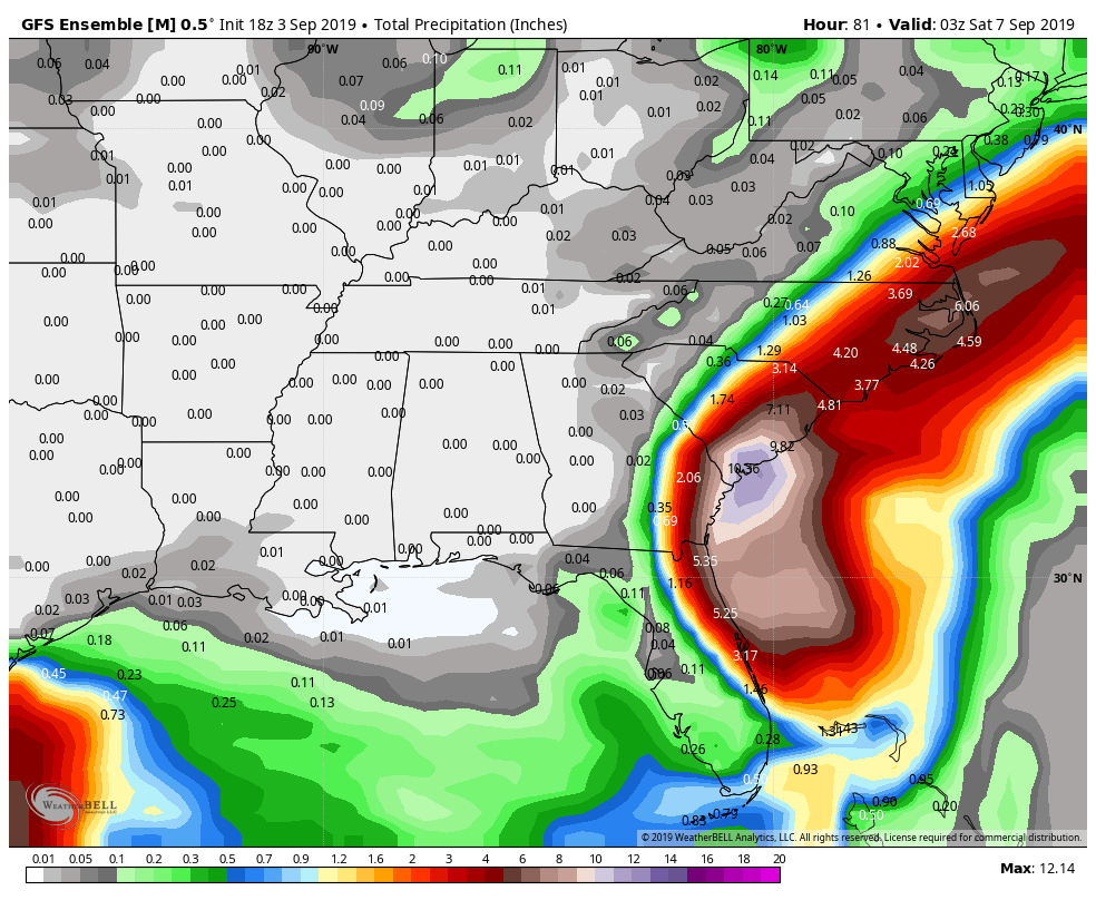
GFS model forecasting total rainfall amounts of 8-12″
Finally – as if the above threats weren’t enough – the potential will exist for tornadoes along the coastline. Atmospheric instability will increase as the system nears the shore, and tremendous low level wind shear will create and environment favorable for tornadoes, especially in South and North Carolina on Thursday.
Evacuation orders have been issued for many low lying and coastal areas in Georgia, South Carolina and North Carolina. Check with your local township or government to confirm if evacuations are in place – and make sure you have a plan as to how to proceed if you live or have friends or residences in those areas.
Dorian will eventually move north and eastward as it heads towards the Mid Atlantic. Other than high surf and a few showers near the coast, the impacts from Dorian in NYC are expected to be minimal. Stay tuned for updates on the storm today.
Trackbacks & Pingbacks
3furniture
Leave a Reply
Want to join the discussion?Feel free to contribute!