-2")
Seemingly annual “1000 year” flood arrives again as Imelda hammers Texas
Two years removed from Hurricane Harvey, which brought over 60″ of rainfall to parts of Southeast Texas, areas near Houston are experiencing generational flooding once again. Rainfall totals of over 40″ have been reported over the past three days from the remnants of Tropical Storm Imelda.
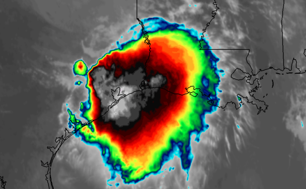
Torrential rainfall is continuing near and east of the Houston metro area this afternoon. In some counties and parishes, the National Weather Service has declared a flash flood emergency. High water rescues have been reported and mandatory evacuations have been issued.
The remnants of Imelda continue to draw on deep tropical moisture to produce torrential rainfall with thunder and lightning. Precipitable water values (in a simple sense, a measure of the moisture content available in the atmosphere) remain incredibly high and plenty of lift still exists for rain to continue to form. Minimal steering in the mid levels of the atmosphere has allowed the system to park itself near the Houston area.

The Weather Prediction Center continues a “High Risk” of flooding in parts of Southeast Texas through tonight. Additional heavy rainfall is expected this afternoon. The good news is that the system is forecast to become gradually less organized by tonight. The circulation of the system will gradually unravel, so while showers and thunderstorms will continue the potential for training bands of heavy rainfall will slowly wane.
Imelda is now the fifth wettest tropical cyclone in United States history, with a maximum rainfall total of 41.81″. Harvey holds the title for rainiest tropical cyclone of all time, with a high rainfall total of 60.58″. Both of the aforementioned events have occurred in Southeast Texas during the past two years.
The propensity for tropical systems to slow down and produce prolific rainfall amounts has been widely accepted as a direct effect of the changing global climate. Systems of this nature, with record breaking rainfall and life-threatening flooding, could become more common in the coming decades as global temperatures rise and atmospheric moisture content increases.
“Because tropical cyclones are carried along within their ambient environmental wind, there is a plausible a priori expectation that the translation speed of tropical cyclones has slowed with warming. In addition to circulation changes, anthropogenic warming causes increases in atmospheric water-vapour capacity, which are generally expected to increase precipitation rates9. Rain rates near the centres of tropical cyclones are also expected to increase with increasing global temperatures.“
Trackbacks & Pingbacks
3untried
Leave a Reply
Want to join the discussion?Feel free to contribute!