-2")
Tropical Storm Warning issued for NYC, NJ as Fay moves northward
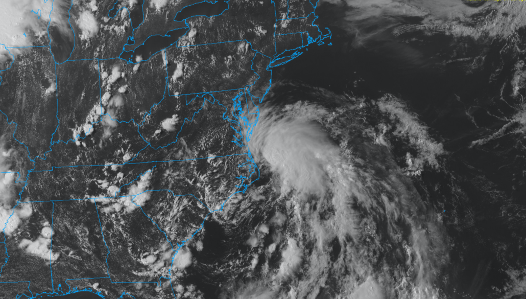
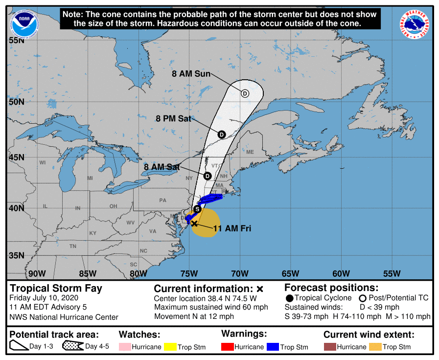
Tropical Storm Fay officially formed on Thursday evening, designated by the National Hurricane Center at 5:00pm EDT. The tropical disturbance had spent the day strengthening and organizing in the warm waters off the coast of North Carolina. The storm will shift quickly northward, impacting the NYC Area with heavy rain and wind on Friday. A Tropical Storm Warning is in effect for the NYC Metro Area from 6:00am on July 10th through 2:00am on July 11th.
Maximum sustained winds are currently near 60 miles per hour and the storm is moving a northward at 12mph. Over the next 12 hours, the storm is expected to pick up speed and move to a position near Tom’s River, NJ by 5pm on Friday. By 8am Saturday, Tropical Storm Fay will be well inland over New York State or Vermont and weakening to Tropical Depression.
Anticipated Impacts & Hazards
Tropical Storm Fay is now a strong tropical system, as it has become better organized on Friday . As it moves northward it will bring with it a tremendous amount of tropical moisture as well as some wind. As a result, there will be a few notable hazards.
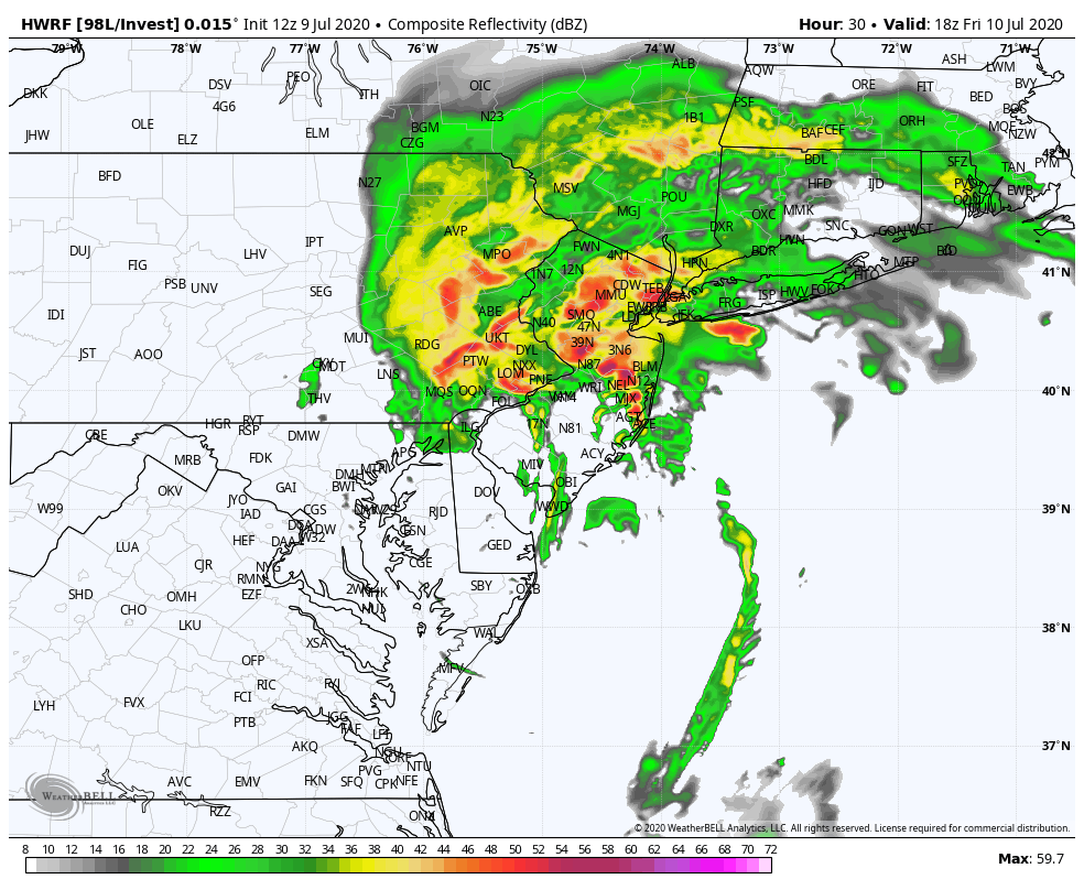
- Heavy Rainfall & Flooding: Expect periods of torrential, tropical rainfall on today. This will start first in Southern NJ and creep northward into Northern NJ, NYC and Long Island during the day on Friday. Precipitable water values near record-high numbers will lead to flash flood potential. The NWS has issued a Flash Flood Watch for the entire area as a result. In addition, strong onshore flow along the area coasts will lead to minor to locally moderate coastal flooding.
- Strong Gusty Winds: The tropical system has strengthened and become better organized this morning. Strong wind gusts over 50mph are possible along the area coasts and could cause localized damage. This includes coastal parts of New Jersey, Long Island, and Connecticut.
- Waterspouts and Tornadoes: While a lower risk overall, the potential will exist for a few waterspouts and tornadoes. Tropical systems have a high amount of wind shear and even very minimal instability could aid in the development of strong or severe thunderstorms. A few waterspouts and tornadoes are possible throughout the area as a result.
From the National Hurricane Center: “Fay is expected to produce 3 to 5 inches of rain with isolated totals of 8 inches along and near the track across the mid-atlantic states into southeast New York and southern New England.”
Timing Regional Impacts
Impacts will be quite different in many parts of the area, and so we’ve chosen to break down the timing and details by region. Here’s what you can expect where you are.
- Southern and Central NJ: Expect heavy rainfall by Friday morning, continuing into Friday afternoon. Strong winds along the coast with the potential for flooding throughout the region. The heaviest rain will end by the middle of the afternoon on Friday.
- Northern NJ, NYC, Long Island: Expect rain to pick up in intensity as Friday morning goes on, with heavy rain during the afternoon and evening hours as well. Strong, gusty winds are expected along area beaches. Expect widespread flooding potential with torrential rainfall. Rainfall ends by early Saturday morning with the storm pulling away.
- Connecticut, Upstate NY and New England: Rain starts later in the day on Friday and continues into the evening, and perhaps even Saturday morning. Expect torrential rainfall at times with localized flooding. Strong winds and coastal flooding can also be expected near the shores of these states.
Preparedness and Safety
There are a few things that you can do in order to prepare for a tropical system. While we do not expect life-threatening weather from this storm, it is always better to prepare adequately in advance of hazardous weather as a general rule.
- Have a flood plan in place. If you live in a low-lying or flood prone zone, know your evacuation routes and know what to do if a flash flood does occur.
- Know that driving into flood waters is perhaps the dumbest thing you could possibly do. Don’t do that.
- Have an emergency plan in place, just in case. This means double checking for things like batteries, essential supplies, backup power sources, etc. You don’t want to be caught without these.
- If you live along the coast, refresh yourself on evacuation routes and know what your plan will be if you have to leave.
- Double check on the elderly and pets to make sure that they are safe.
All in all, Tropical Storm Fay is expected to bring light to moderate impacts to the NYC Metro Area as a whole. The most prominent impact will be heavy rainfall and the potential for flooding, but as mentioned we are also carefully watching the potential for strong wind gusts as well as a few waterspouts and tornadoes.
Stay tuned over the next 24 hours as we ramp up our live coverage of the event.
Trackbacks & Pingbacks
1valerian
Leave a Reply
Want to join the discussion?Feel free to contribute!