-2")
Laura expected to track into Gulf of Mexico, threaten TX/LA coast this week
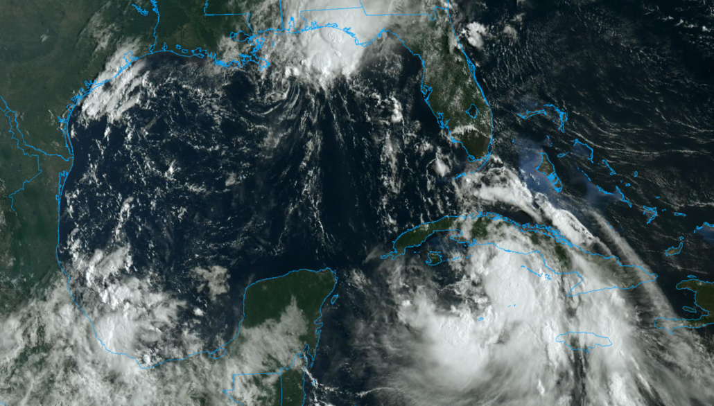
Tropical Storm Laura continues its trek through the waters south of Cuba this morning. The storm has managed to avoid significant land interaction thus far, readjusting its center south of the shore. The National Hurricane Center says maximum sustained winds are 65 miles per hour. The system is expected to emerge into the Gulf of Mexico on Tuesday.

Laura has evaded most forecast models projected tracks over the past 24-48 hours. Originally expected to track directly over Cuba, the storm readjusted its low level center to the south of the island yesterday. Guidance has struggled to readjust to the storms new (and quickly changing) center position.
This morning, the storm was located a good bit south of the Cuban mainland, near Cayo Anclitas. The storm is expected to continue tracking northwestward over the next 12 hours, and eventually it will cross Cuba again near San Cristobal. NHC is not forecasting the storm to reach hurricane strength during this time.
A great deal of uncertainty continues regarding the storm systems track and organization over the next 12 hours. Recent satellite trends suggest that the storms low level center is heading westward, but convection has been slow to wrap totally around it. Northwesterly wind shear, and interaction with the landmass of Cuba, has largely prevented this from occurring, with the majority of deep convection remaining biased to the south.
It remains to be seen exactly when this will change. Some short term/mesoscale models suggest that the more substantial inner core could develop later tonight into Tuesday morning. Conceptually, this would make sense – as the storm tracks a bit further away from the Cuban land mass and into warm waters.
Emergence into the Gulf on Tuesday
Laura will emerge into the Gulf of Mexico on Tuesday, after crossing Cuba near or south of San Cristobal. The forecast will reach its critical inflection point soon after this time frame, as the system quickly begins to encounter warm waters and an environment with very low wind shear. This will support strengthening.
Forecast model guidance begins to display a notable amount of disagreement by later Tuesday as Laura tracks into Gulf of Mexico and begins to strengthen. Some models and ensemble members take the system further north, towards the Louisiana coastline. Others track the storm further west, on a path towards the Texas coast.
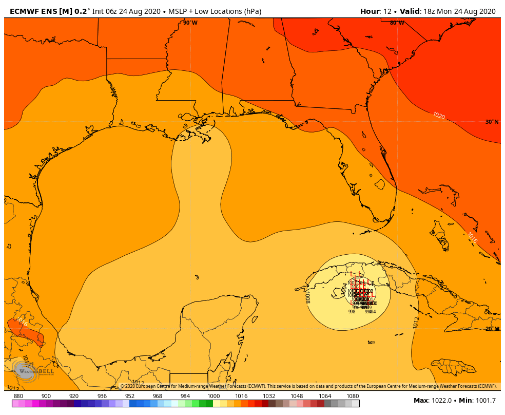
What could be causing such a tremendous difference, resulting in a 300+ mile spread in possible track? The answer lies in the storms eventual strength. That’s right – exactly how strong Laura becomes when it reaches the Gulf of Mexico will play a major role in determining where the system tracks.
A weaker, less organized system will be steered by lower and mid level winds in the atmosphere, which have a more northerly component to them. This would guide the storm towards Louisiana or perhaps Eastern Texas. A stronger, deeper Laura would be steered by upper level environmental winds. This would guide the storm further west towards Texas.
Exactly how much Laura strengthens remains uncertain (hence the large spread in potential track). The overall environment remains highly favorable with warm ocean heat content and low wind shear. But the structure of the system remains uncertain, and we won’t truly know how it will react to this environment until it emerges from Cuba on Tuesday.
What to expect as the storm approaches the coast
Regardless of what happens on Tuesday, Laura is forecast to approach the Gulf Coast on Wednesday. It could be a stronger (Category 2 or 3) hurricane, especially if it takes a more westward track, or a weaker but still formidable hurricane if it takes a more eastern track.
As the system approaches the Gulf Coast on Wednesday, there are some signals from model guidance that environmental wind shear could increase. This could, conceptually, help weaken the system as it approaches land – but such an event remains highly uncertain at this time.
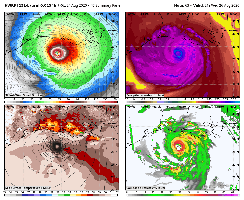
Laura is likely to make landfall, either on the Texas or Louisiana coast, as a hurricane on Wednesday. The storm is likely to feature torrential tropical rains, strong winds, and a formidable storm surge. The details of where these impacts will be most greatly felt, and how severe they will be, remain uncertain at this time.
Residents along the entire coastline, from Brownsville, TX to New Orleans, LA, should be making hurricane preparations now. Do not wait until the systems track becomes more certain to finalize your plans. You do not want to have to scramble to organize yourself with a hurricane bearing down.
There are a few important steps that you can take to help you and your family prepare:
- Develop a hurricane plan and discuss it with your family. Know where you will go, what you will bring, and how you will get there if and when the time comes that you need to move.
- Have a hurricane kit handy. This includes essential tools, non perishable foods, and supplies.
- Know your flood zones in your local area. It is critically important to know which areas will flood first and how you should react.
- Know your evacuation routes. Research the routes and understand how you will need to get there if an evacuation is ordered.
- Check official sources for weather information – most importantly, the National Hurricane Center and your local governments.
Trackbacks & Pingbacks
sun
3forensic
Leave a Reply
Want to join the discussion?Feel free to contribute!