-2")
Major winter storm expected in NYC from Wednesday into Thursday
A significant winter storm will impact the NYC area later this week, with heavy snowfall expected from Wednesday afternoon into Thursday. Significant accumulating snow plus strong, gusty winds will lead to hazardous travel conditions. Isolated power outages are also possible. As a result, the National Weather Service has issued a Winter Storm Watch for the NYC Metro Area and surrounding parts of NJ and CT from late Wednesday into Thursday.
The disturbance which will eventually produce the winter storm in the NYC Metro Area is already in the United States currently traversing the four corners of the Southwest US. This disturbance will move eastward over the next day or so, through the Central United States and eventually towards the Mississippi Valley. As it does so, it will begin to amplify and strengthen.
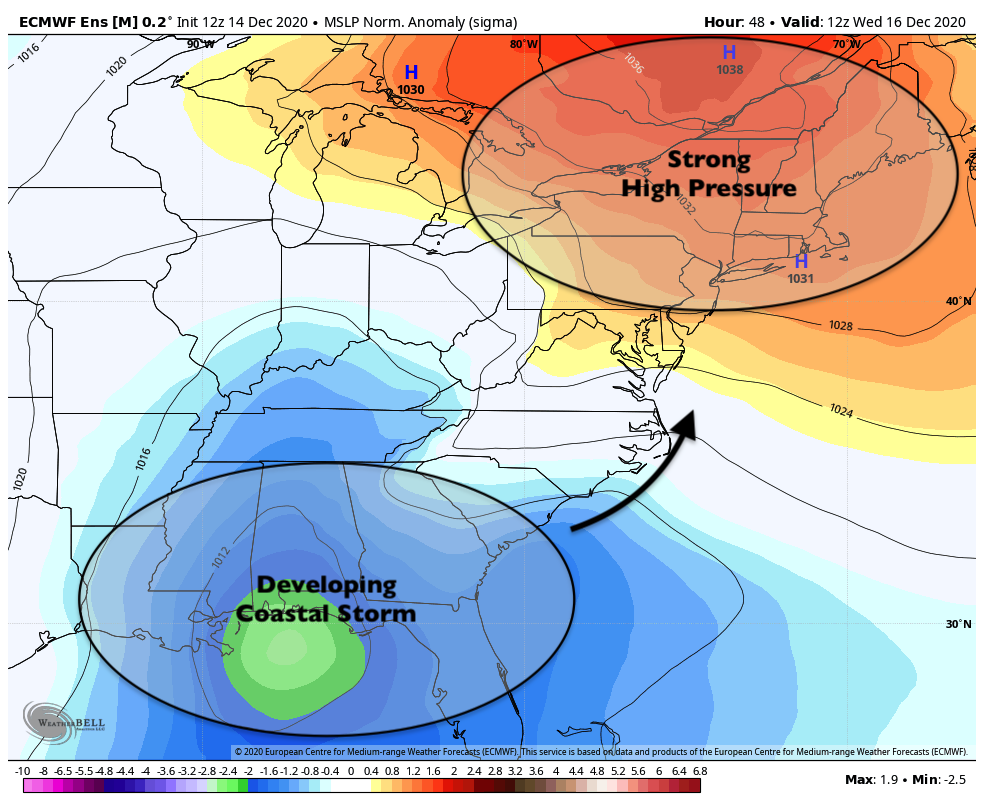
Meanwhile, a strong high pressure system will begin to develop across Southeast Canada and Northern New England. This high pressure system will funnel cold air southward from Canada into New England and the NYC Metro Area from later Tuesday into Wednesday. As the aforementioned disturbance begins to amplify up the east coast, it will begin to encounter resistance from the cold air and high pressure to its north.
This evolution will set the stage for a significant winter storm throughout the Northeast states, as an an amplifying disturbance encounters a cold high pressure system. Snow will spread throughout the Northeast states on Wednesday afternoon and evening, and the storm will continue through Thursday. The gradient between the developing low pressure and strong high pressure to its north will lead to an enhanced risk of strong wind gusts as well.
When all is said and done, significant snowfall totals are expected and blizzard conditions are possible. This will likely be an impactful winter storm with a broad area of hazardous weather, including the potential for difficult or impossible travel and isolated to scattered power outages.
Anticipated timing and impacts
The storm is expected to move in to the NYC Area relatively quickly on Wednesday afternoon and evening, with snow becoming heavy quickly after it begins. This will lead to the potential for rapidly developing travel difficulties. Here’s how we expect the event to shake down in Northern NJ and NYC:
Wednesday Evening (6:00pm – 9:00pm): Snow begins quickly from west to east. Snowfall rates could become heavy rather quickly with accumulations on all surfaces.
Wednesday Evening (9:00pm – 12:00am): Very heavy snow is likely during this time with periods of near whiteout conditions. Gusty north/northeast winds are also anticipated.
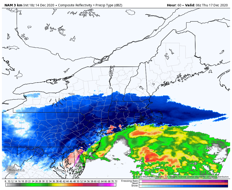
Thursday Early Morning (12:00am – 3:00am): Moderate to heavy snow continues. A period of sleet is also possible during this time, especially along the south shore of Long Island including parts of Brooklyn and Queens. Travel will remain difficult with strong winds and moderate to heavy snowfall
Thursday Morning (3:00am – 6:00am): Light to moderate snowfall will linger but begin to wane in intensity from west to east. Travel will remain extremely difficult and strong winds will lead to blowing and drifting of snow. Snow may persist into late morning or perhaps even the afternoon, but will become much lighter by that time.
Forecast and uncertainties
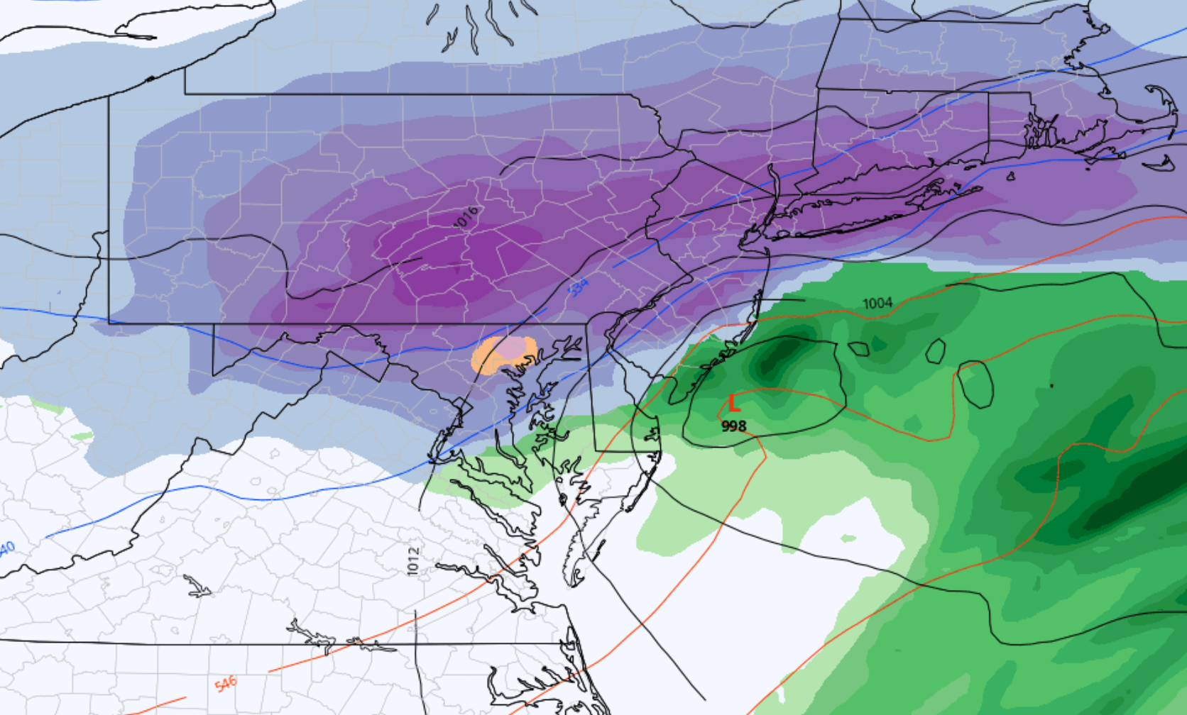
Our current forecast calls for 8 to 12 inches of snow in the greater NYC Metro area. As is often the case, the expectation is for higher amounts just to the northwest of the city and lesser amounts to the southeast and closer to the coast. In this particular case, the snowfall gradient could be quite dramatic especially across parts of Central New Jersey.

The main uncertainty in regards to this storm is how far north and west the low pressure area tracks. Forecast model guidance has waffled over the past few days regarding the placement of the storm as it moves to a position near the New Jersey coast. A stronger storm, tucked in closer to the shoreline, could lead to a warmer overall solution with slightly less snowfall in the NYC Metro area. A slightly weaker storm, tracking slightly further off the coastline, would generally lead to a more wintry outcome.
Ensemble data remains split on exactly where the system will track – and accordingly, the forecast is only of moderate confidence. The range of anticipated snowfall in the NYC metro area remains 8 to 12 inches, but ensemble data range on the outer periphery expands from 4 inches to nearly 18 inches.
Over the next 24 hours, the track of the system should become more clear. This will allow us to become more confident in where bands of heavy snow will set up, and the storm total snowfall forecast map is likely to be tweaked and adjusted during that time.