-2")

First snow threat of the season likely to scrape NYC on Monday
Winter has felt more like an extension of autumn so far, with mild temperatures and not even the slightest hint of snow. That will change over the next few weeks, as the weather pattern turns colder and remains active. The first real threat for winter weather this season comes on Monday, as a low pressure system develops off the Mid Atlantic coast.
Forecast models have been hinting at the potential for winter weather from this system for a few days. The disturbance responsible for the storm system tracks from the Mississippi Valley to the East Coast later tonight. As of late last week, most model guidance suggested that the storm would pass harmlessly offshore.
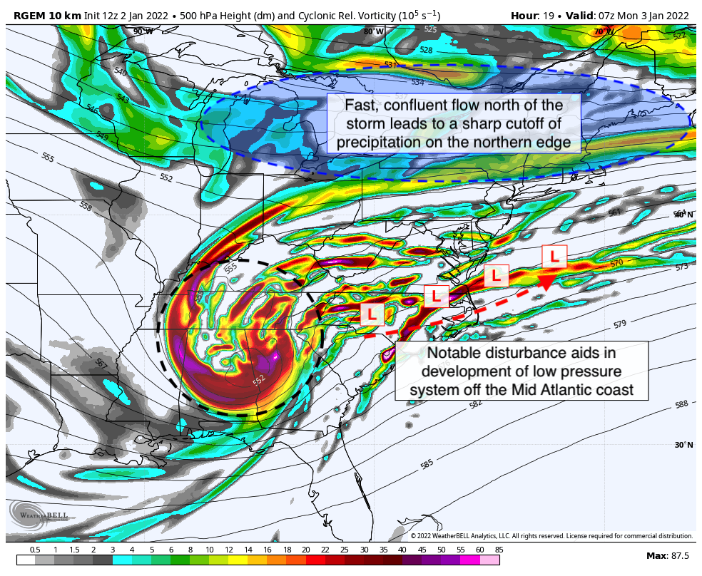
Over the past 24-48 hours, however, guidance began to trend much more amplified with this disturbance. A more organized, deeper system develops in the Southeast US, leading to a more energetic and amplified storm moving along the East Coast. Low pressure develops and strengthens over the Carolinas before shifting eastward out to sea.
The amplified trend with the disturbance has also led to a more impressive jet streak in the mid and upper levels of the atmosphere. This results in enhanced lift, and forecast models have expanded the precipitation shield with the system accordingly. As a result, a substantial winter storm appears likely in the Mid Atlantic states.
In the NYC Metro, the forecast is not so clear cut. A fast and confluent flow to the north of the storm results in a strong 1030hPa high pressure over New England. Despite the system trending stronger and more amplified, the high pressure to our north ensures that there will be a very sharp cutoff between accumulating snow and nothing at all.
Forecast model guidance, as you may imagine, is currently struggling mightily with pinning down where that cutoff will be. A handful of guidance suggests accumulating snow reaches NYC, while another handful suggests the metro will see nothing but cirrus clouds. A meteorologists nightmare.
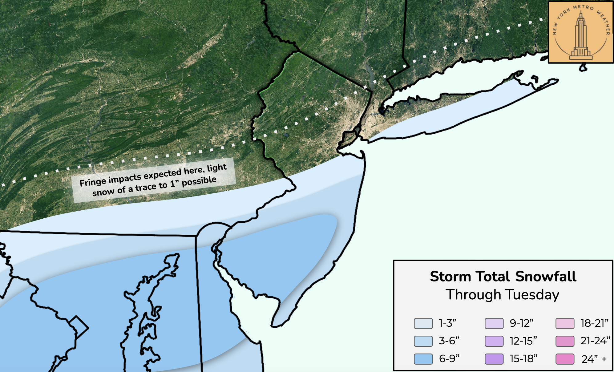
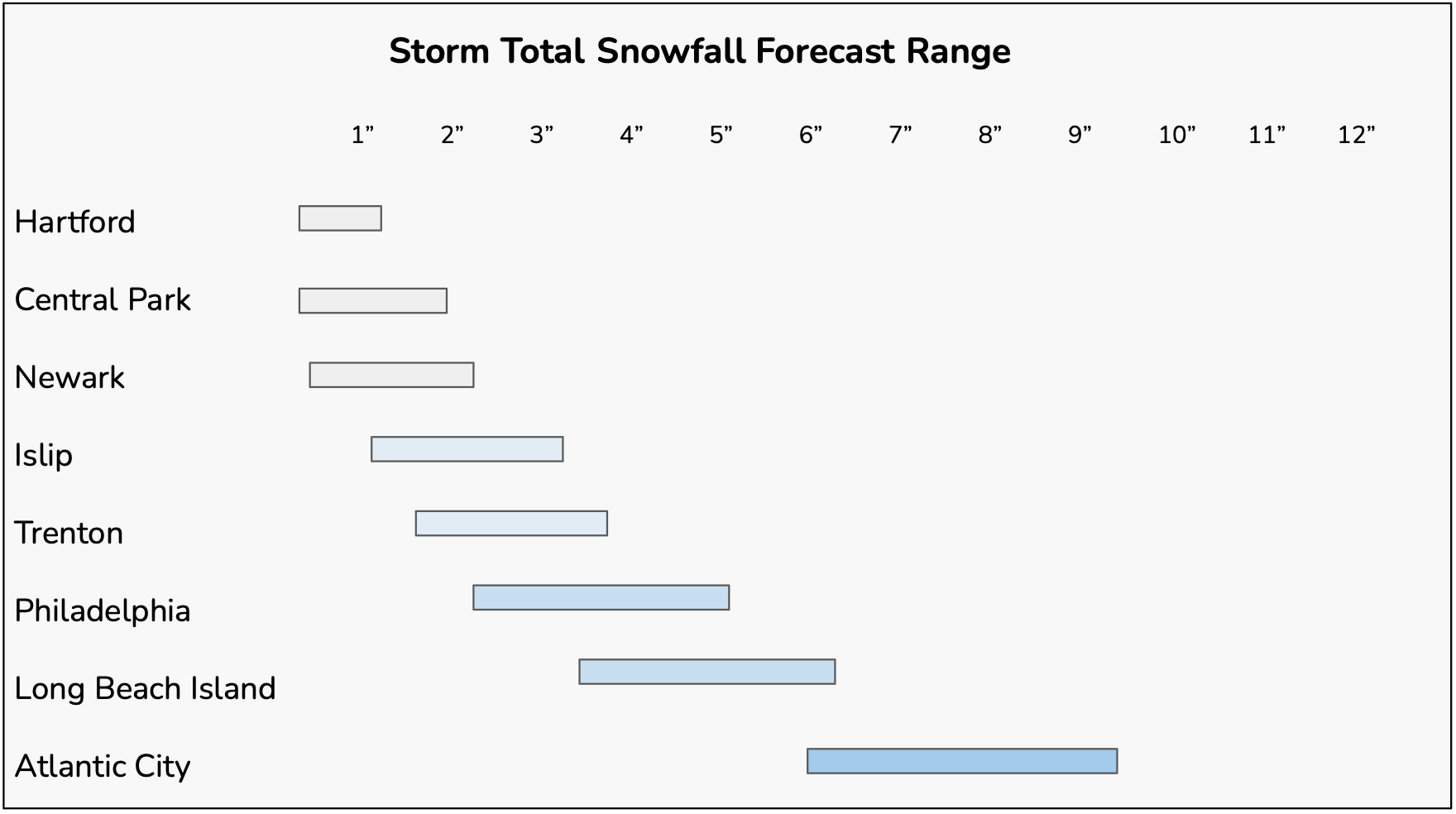
Utilizing our knowledge of how these events typically transpire, plus weighing the model trends and similar events of the past, we can at least begin to formulate a forecast that we are comfortable with. At the moment, that includes only a fringe impact event in the NYC Metro, with perhaps a trace to an inch of snow. A snowfall of 1 to 3 inches appears more likely to the south the Driscoll Bridge in New Jersey. 3 to 6 inches of snow is possible to the south of the Philadelphia metro, and locally 6 to 9 inches of snow is possible in parts of Southern New Jersey.
What to expect in terms of timing and impacts
3am through 6am: Snow, perhaps starting as a wintry mix, will spread into much of Southern and Central NJ during this time. Snowfall rates are initially expected to be quite light, but will pick up in intensity across Southern NJ as time goes on. Conditions will remain dry and quiet for all other areas.
6am through 9am: Snow is expected to become heavier in parts of Southern NJ during this time, with snow also spreading northward into parts of Central NJ. The Philadelphia metro will remain on the fringes of impacts during this time period. Travel may begin to become difficult in Southern NJ. Conditions will remain dry and quiet in NYC and Northern NJ.
9am through 12pm: Heavy snowfall is anticipated in Southern NJ, with at least light snowfall impacting the Philadelphia metro and Central NJ. Fringe impacts may begin to reach parts of NYC and Long Island during this time. Travel is expected to be quite difficult in Southern NJ and Delaware during this time.
12pm through 3pm: Heavy snow will continue across much of Southern NJ and the NJ Shore. Snow may spread into parts of Long Island during this time, but is expected to remain light. The Philadelphia metro could also see light snow during this time frame. The NYC Metro will remain on the fringes of the system, but some light snow is also possible there during this time frame (very little accumulations anticipated).
3pm through 6pm: The storm will begin to wrap up, with any snow ending in the NYC and Philadelphia metros during this time. Heavy snow and gusty winds will continue in Southern NJ and the Southern NJ shore, but begin to wrap up towards the end of this time frame. The system is then expected to gradually pull away from the area
Stay tuned for further updates over the next several hours as the system begins to evolve and confidence increases in storm specifics.
Güncel istanbul hurda fiyatları ile İstanbul’da hurda alan yerler içerisindeyiz. Size en yakın istanbul hurdacı firması olarak hizmet sunuyoruz. En yakın hurdacı firmamıza hurda satabilirsiniz.
Not going to be the first snow this winter. We had snow in Sunnyside (Queens) one morning a few days before Christmas – gone by afternoon I recall.