-2")
Winter Weather Advisory Issued for NYC Ahead of Saturday’s Bomb Cyclone
A strong low pressure system will develop along the East Coast this weekend – strengthening rapidly enough to be characterized a “bomb cyclone – bringing a myriad of hazardous weather to the Northeast states. Heavy rain, wintry mix, snow and gusty winds are all expected in the NYC Metro on Saturday. The National Weather Service has issued a Winter Weather Advisory for the NYC Metro on Saturday.
The storm system’s development is already underway across the Tennessee Valley and will continue over the next several hours. Low pressure will move northeastward towards the Mid Atlantic Coast tonight. By Saturday morning, a strong low pressure system will be situated east of New England, having deepened considerably in just 12 hours time.
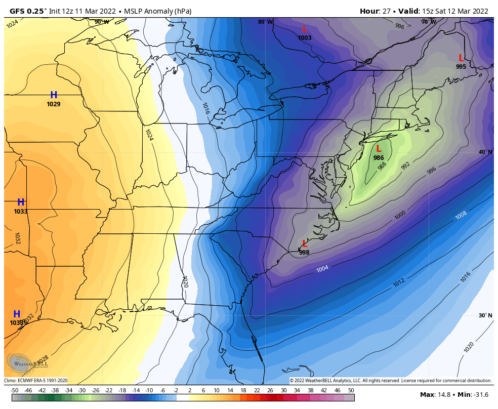
A bomb cyclone is a friendly term for a rapidly strengthening area of low pressure, also known as explosive cyclogenesis. The technical definition requires the storm to strengthen by at least 24hPa over a 24 hour period. This storm easily reaches the criteria, dropping from 1008hpa to 973hPa in just 24 hours time through Sunday morning.
The impacts on the NYC Metro area will be complex. The atmosphere will be quite warm initially, allowing precipitation to fall as rain. As the system strengthens, however, the dynamics of the storm will pull colder air into our region resulting in a rapid temperature drop and a change to a wintry mix and eventually snow. The system will have three distinct “parts” (think of it like a very dramatic, increasingly uncomfortable play).
Part 1: Friday PM into Saturday Early AM
Rain is expected to begin in New Jersey and the NYC Metro very late Friday evening into the early morning hours of Saturday. This rainfall could be heavy at times, with localized ponding expected on area roadways. There is plenty of moisture available in the atmosphere for this storm, which helps add confidence in the rainfall rates.
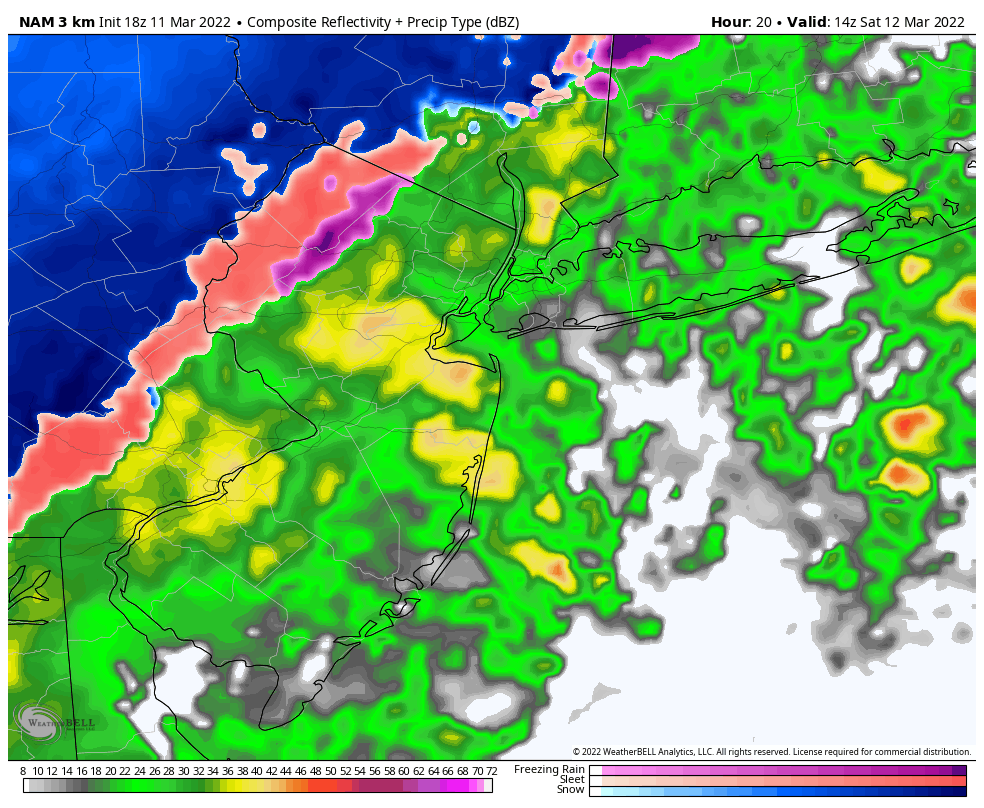
This rain should continue into the early morning hours of Saturday as the system begins to rapidly deepen offshore. Precipitation intensity should gradually increase as we move towards daybreak on Saturday. Strong, blustery winds will also begin – particularly near the coast which will be closest to the low pressure area.
Part 2: Saturday AM through Saturday Early Afternoon
The low pressure system will begin to rapidly deepen off the coast, pulling cold air in towards itself. This will begin the process of a notable temperature drop in the region, and a transition from rain to snow. The transition will occur from west to east. Higher elevations of New Jersey and Southeast New York will change to a mix and then snow first.
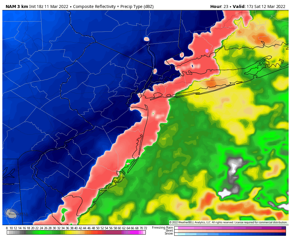
Gradually, as we move into the late morning and early afternoon, the mixing line will move eastward into Northeast New Jersey and eventually the NYC Metro. Rain will transition to a mixture of sleet and snow, and eventually will change over completely to snow. Temperatures are forecast to drop considerably, falling near and then eventually below freezing. This will result in a high likelihood of slick and icy conditions. While accumulations should initially be relegated to colder surfaces, especially in the city, roadway accumulation is not impossible especially in the suburbs.
Winds will become quite blustery out of the northwest. Gusts to 35 or 40 mph are expected in Northeast New Jersey and the NYC Metro region, with stronger gusts along the coast and on Central and Eastern Long Island.
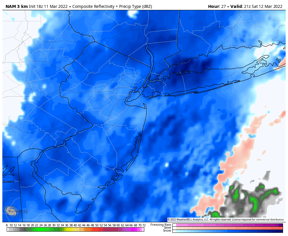
Part 3: Saturday Afternoon into Saturday Evening
Temperatures will continue to drop rapidly through the evening, falling well below freezing. Light to moderate intensity snow should continue throughout the entire area at least for a few hours before beginning to end from west to east. Strong west and northwesterly wind gusts will continue.
During this time, roadways and other surfaces are most likely to become icy as temperatures will have continued to fall while wintry precipitation continues. Expect slick conditions on Saturday evening if you are traveling and leave yourself some extra time.
Summary, Hazards and TL;DR
A strong and complex storm system will impact the area from late tonight into Saturday. If you have travel plans on Saturday, consider moving them or prepare to leave yourself extra time to travel. Rain is expected late tonight into Saturday morning, followed by a transition to snow from west to east. This includes the NYC Metro. Several inches of snow is expected in the higher elevations of Northern NJ and Southeast NY, and light accumulations are possible in the NYC Metro – although mostly on colder surfaces. Still, gusty winds and rapidly falling temperatures will lead to icy and slick conditions from Saturday afternoon into Saturday night. Improving weather is anticipated on Sunday.