-2")

Flood Watch issued for NYC from Friday through Saturday
The National Weather Service has issued a Flood Watch for the entire NYC Metro from Friday evening through Saturday. Locally heavy rain is expected to produce the potential for flooding in some areas. 1-2″ of rain is currently expected but locally higher amounts up to 4″ are possible.
Right off the bat, it’s worth noting that this event is not similar to the one which brought significant flooding to NYC last Friday. However, it is still expected to be impactful with periods of steady or heavy rain and flooding – especially in poor drainage or low lying areas. The heaviest rain currently looks likely to fall from the late morning into early afternoon hours on Saturday.
Short term forecast model guidance adds some concern for a localized band of heavy rain which could develop near the NYC Metro on Saturday morning. Recent runs of the HRRR and NAM model show locally heavy rainfall in a slow-moving band and anomalous moisture in place. These ingredients could lead to higher intensity rainfall and the excessive runoff could lead to flooding problems.
The combination of anomalous, tropical moisture and lift to form precipitation is the same one that has brought localized flooding events to the NYC Metro area in the past. They can foster the development of slow moving bands of precipitation that train or stall over localized areas and produce torrential rainfall in short periods of time.
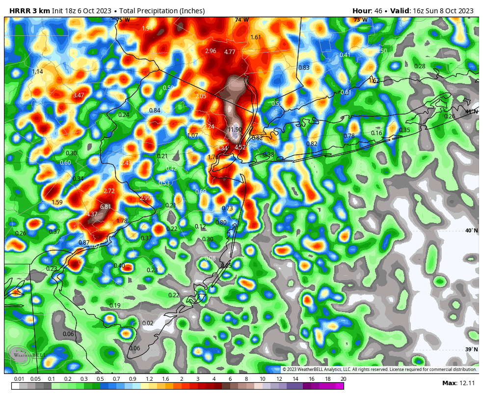
The location where this band sets up is still somewhat uncertain, with guidance placing the band anywhere from Northeast NJ to Long Island. The areas impacted by this slow moving band are most likely to see flooding, while areas around it will still see steady rain but of lower intensity and concern overall.
The system is eventually expected to exit the region on Saturday evening as a strong cold front sweeps through. Cooler air will pour in by Saturday night with strong wind gusts and much lower dew points signaling the entrance of a decidedly autumn-like airmass.
As we always stress with these types of storms, it is critical to know your flood zones and have a plan if you live in a flood prone area. Have a way to receive weather warnings – including turning emergency alerts on your cell phone. Stay alert on Saturday until the system has departed the area, and of course stay tuned to our accounts for the latest updates as we will be tracking the storm with you as the day goes on.