Pleasant weather, wet weekend, foliage update

The weather over the past several days has been astonishingly pleasant – with highs in the low to mid 70’s, abundant sunshine and low humidity. A Canadian high pressure, which settled into the area earlier this week, has modified a bit — but continues to provide benign weather and comfortable air. The low humidity and near-average highs for this time of the year are comfortable by nature. The deep blue skies will continue for another day on Thursday, with highs expected to reach into the middle to upper 70’s. A few clouds could sneak in on Friday, but the idea of calm weather and comfortable air will continue. Thursday Night will still be a bit brisk, with lows falling into the 50’s.


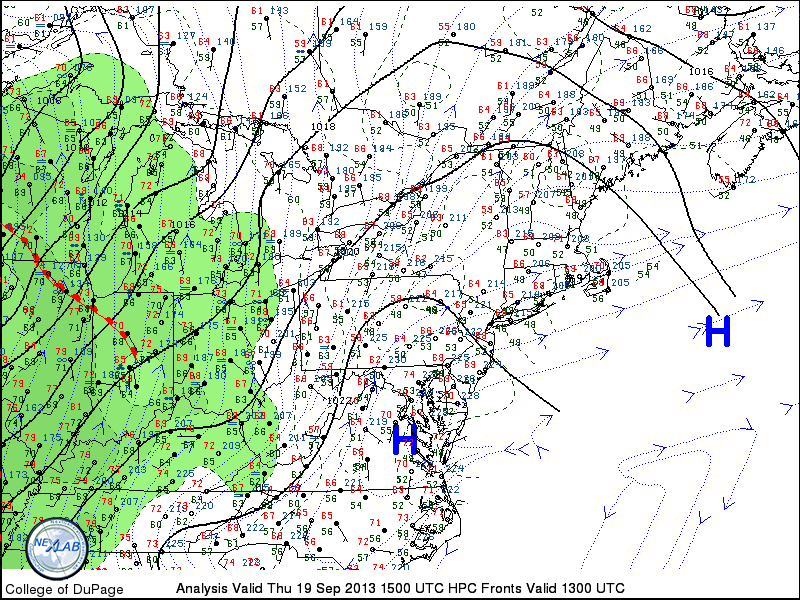
Surface analysis and observations from the morning of September 19th, 2013 in the Northeast US, showing a high pressure in control but beginning to weaken.

Surface analysis and observations from the morning of September 19th, 2013 in the Northeast US, showing a high pressure in control but beginning to weaken.

Read more

PM Update: Another cool night on the way

The cool airmass which was in place throughout the area on Monday will remain through Monday Night and most of Tuesday, with a cool overnight period and early morning expected on Tuesday. Temperatures are forecast to drop into the

NAM Model forecasting low temperatures in the 40’s inland and 50’s in New York City for the morning of Tuesday 9/25/12.

40’s once again over the interior suburbs of New Jersey, New York, and Connecticut. Temperatures on Sunday Night/Monday morning bottomed out in the upper 30’s in some isolated locations including the Pine Barrens of Central New Jersey, the Northwest NJ Hills, and much of Interior New England. Although temperatures could end up a few degrees warmer overnight Monday Night into Tuesday, the general trend will continue to be an autumn airmass which is more cool and crisp than anything to push through the region since early last Spring. Still, a warmup in the middle of the week should serve as a reminder that we are still very early in the Autumn season, and temperatures are forecast to rise into the 80’s ahead of a cold front which will pass the area Wednesday. Some showers and thunderstorms will once again be possible with the frontal passage — with another cooldown expected thereafter, leading us to the end of the work week.

Keep reading past the break  for more information on the forecast — and a fall foliage update!

Read more

First signs of fall foliage begin, right on schedule

It’s almost theatrical how, without fail, the first signs of fall foliage begin to show their colors (no pun intended) within a few days of the calendar start of the Autumn season. With autumn set to begin this Saturday, September 22 2012, it should
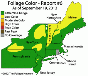
Fall foliage color data, courtesy of The Foliage Network. Image and data valid as of September 19th, 2012.

be no surprise to anyone that the first signs of fall colors are appearing over parts of New England, Southeast New York, and Northern New Jersey. Now, it should be mentioned that these colors can typically take a few weeks to work their way down to the immediate suburbs of New York City, as well as Central New Jersey, Connecticut and Long Island. Yet, one can already observe hints of the impending explosion of natural color in the tips of trees or those exposed to more sun than others on a daily basis. Some will spend the next few weeks longing for one more warm, muggy summer night while others will be teeming with excitement as the colors fill the trees and warn of the impending winter. Our friends at the Foliage Network provide excellent map analysis of the progression of the leaf color and leaf drop through the Northeast United States. Their latest report, pictured in this post from September 19th 2012, shows Low color spreading throughout much of New England and even into the mountains of Northern New Jersey.

All of this is a lot to take in, but there’s even more interest to it! Despite a usually timely start, each season provides different foliage timing and patterns depending on the weather patterns and temperatures. For instance, comparing the report from September 19th 2012 to the report from September 17th, 2011 (just a two day difference) shows that we are way ahead of last years pace at this point. The “Low color” category foliage is hundreds of miles farther south and more widespread throughout New England. As the season gets going, we’ll be sure to keep you updated on the foliage progression!

In addition, we’ve opened a Flickr Group to our readers and subscribers (yes, it’s free) for all to post their fall foliage pictures throughout the season. The group will remain open for the future, as well, hopefully serving as a central point for NYC weather and nature related photography. We can’t wait to see your best photos!