-2")
Overview
Briefing
Hot and humid conditions will continue through Tuesday. Chances for showers and t-storms will increase as a cold front approaches on Wednesday. More comfortable warmth and humidity is expected late week.
Forecaster’s Discussion
Last Updated: 9:30am Thursday, July 26th 2019 by MP
Near Term (through tonight)
High pressure will provide mostly sunny skies today. 850mb temperatures around 12-13 C with deep mixing and light northwest downslope winds will support high temperatures closer to normal-in the middle 80s throughout much of the region. Humidity will still be relatively low, which will make for another beautiful mid-summer day.
Tonight, will remain mostly clear with light winds. This will result in more radiation cooling. Low temperatures are likely to in the mid 60s many of suburbs and in upper 60s to near 70 degrees in NYC and urban areas. Some of the far northern Interior valleys will likely drop into the upper 50s to lower 60s.
Hello
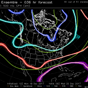
Zonal Pattern Gives Way to More Extremes Across the Country
Good Evening! A weak area of mid level energy moved quickly through the Northeast last evening and into the early morning hours today, which had just enough kick left to it to bring some isolated and relatively light areas of precipitation. Depending on your location, this precipitation varied from plain rain, freezing rain, or even some light […]
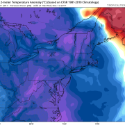
Wintry Mix for Interior Northeast Tuesday Before Arctic Blast Arrives, Late Week Storm Threat?
Good evening! Chilly and dry weather will continue for rest of the evening hours. But clouds will thicken and increase overnight, as the next storm system approaches. Mid-level warm advection ahead of warm front will start to cause Some light precipitation to break out well after midnight. Temperatures in the lower and mid-levels will be […]
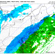
First Widespread Snowfall of the Season Likely Saturday!
Good Evening Folks! Well the close-call we warned you about on Monday has trended much closer to the coast over the past 48 hours, and looks to deliver the first light to moderate snowfall for many locations long the I-95 corridor! The setup for this storm has been a cold one, as a weak area […]