-2")
Rain on Monday, Arctic Blast on Tuesday and Wednesday
We hope you’ve been enjoying your weekend so far! After a very chilly start, the airmass has warmed a bit today, as winds have shifted to the southwest ahead of a developing storm and cold front. However, thickening clouds may largely prevent us from warming at the surface much more than yesterday. If clouds were to break, high temperatures could approach 50 degrees; otherwise it’s likely that we stay in the mid 40s.
Meanwhile, a strong storm system continues to develop, amplifying heights out ahead of it. This leads to strong mid-level warm air advection, and will continue to moisten the atmosphere. This warm air advection may lead to some showers developing well ahead of the low by around 11:00pm, and it may come down moderately at times in the pre-dawn hours. This will also lead to temperatures holding steady in the mid 40s.
Although there has been a warming trend with this storm, SW winds take a longer time to warm up the hills of NW NJ, and interior SE NY. This leads to the possibility of a bit of snow and ice on the onset for western Passaic and Sussex Counties in NJ, Northern Fairfield County in CT, and Orange and Putnam Counties in NY. Winter weather advisories have been issued for those areas, where up to an inch of snow is possible, and less than a tenth of an inch of ice. The timing would be from around 11:00pm through 7:00am. It may be wise to leave a bit of extra time for an early-morning commute. After 7:00am, enough warm air will be around to raise temperatures in these areas above freezing.
Some data is hinting that there may be a bit of a break in the action for a few hours from about 6:00am through 9:00am or so, where rain becomes much more scattered. This is because we’ll be in between the initial lift from the overrunning, and the core of the heavier rain from the warm conveyor belt of the storm.

Today’s NAM Model valid for 1:00pm tomorrow shows steady rain moving into the area, with a strong SW flow ushering in 850mb temperatures of +10C. Jet stream dynamics are impressive as 130+ knot winds at 300mb are widespread to our west.
After 9:00am is when the more widespread rain moves in, which will generally come down at a moderate intensity throughout the day. As southerly flow increases, temperatures will warm into the mid to upper 50s for most of the region and 850mb temps to warm to around +10C. Come mid-afternoon, this will also allow dewpoints to rise into the mid 50s, creating a warm and moist atmospheric profile. This leads to precipitable water values rising to near 1.4″ — a value that is not typically seen in the cold season. This, combined with a trailing cold front from the storm system leads to the possibility of a squall line — with heavy downpours possible. We do not think instability is strong enough for strong wind gusts, or thunder, but that cannot be ruled out.
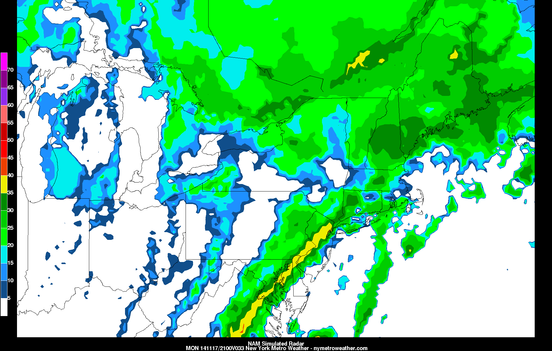
Today’s NAM Model valid for 4:00pm tomorrow shows a line of very heavy rain developing, which could cause localized flash-flooding.
Rain should begin to taper off between 7:00pm and 9:00pm from west to east, but not after a general three quarters to an inch and a half of rain. Some areas who get into the line of heavy rain could pick up locally higher amounts, as well as some localized flash-flooding.
Afterward, the big story becomes the cold. Cold air advection will be incredibly strong behind the cold front, as 850mb temperatures will go from +10C at 4:00pm tomorrow, to -15C at 4:00pm on Tuesday — a 25C drop!
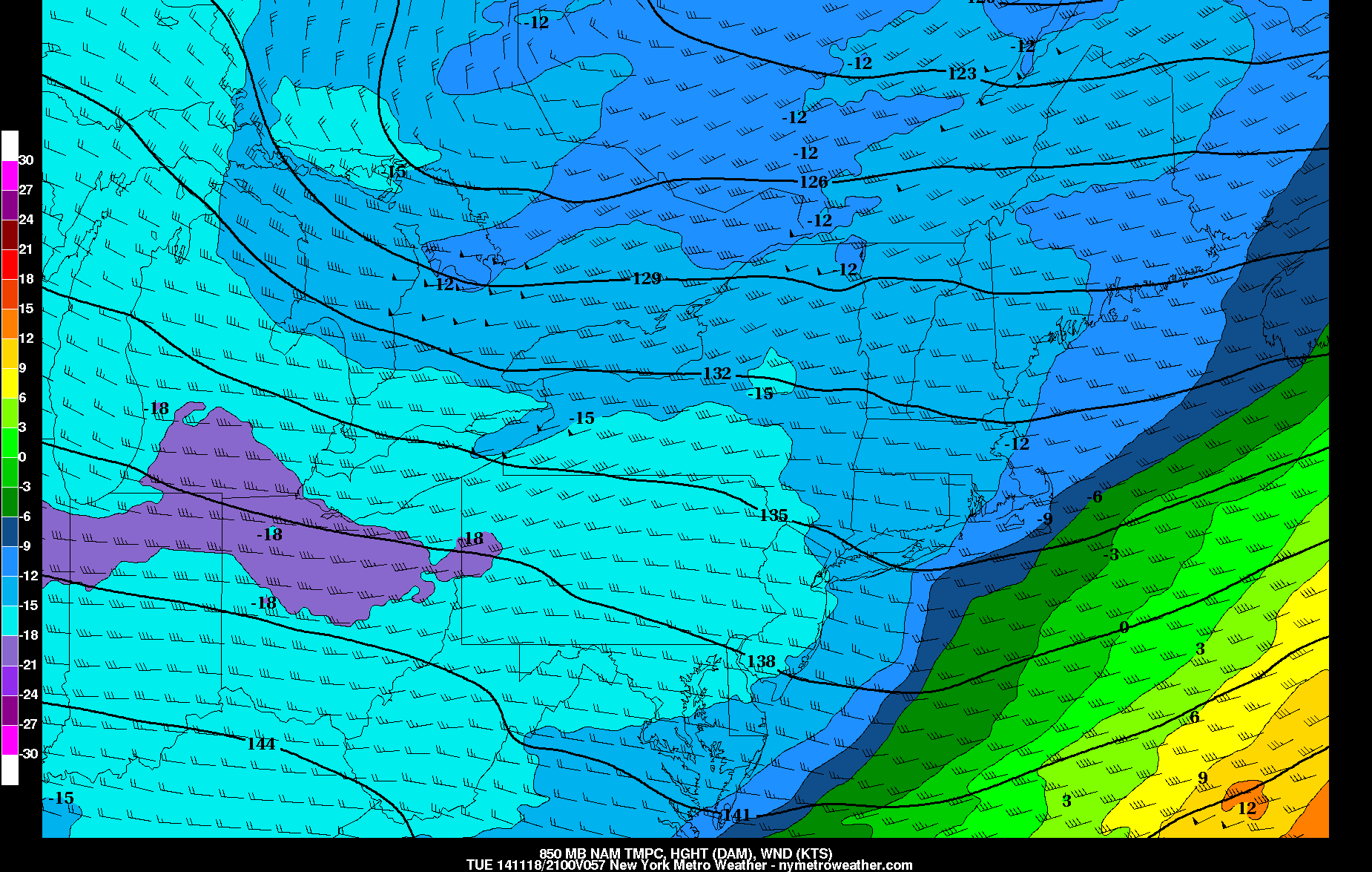
Today’s NAM Model valid for 4:00pm on Tuesday shows 850mb temperatures falling to -15C, which leads to temperatures barely getting above freezing during the afternoon.
This looks like one of those situations where Tuesday’s high temperature may occur at midnight in the mid 40s, but then fall throughout the night and even during the day — or at the very least remain steady during the day. Temperatures should fall into the low to mid 30s by sunrise Tuesday morning, but will not warm up at all during the day. Strong northwest winds will make it feel like it’s in the 20s.
Winds will diminish, but still be breezy on Tuesday night. Skies will also be clear. This will allow temperatures to plummet, as low temperatures will be in the teens for most areas, and even lower 20s in NYC.

Today’s NAM Model valid for 7:00am on Wednesday shows widespread teens for the region, with lower 20s in NYC.
On Wednesday, the core of the cold will move to our east, and with westerly winds, some downsloping will help warm temperatures back into the upper 30s. After another chilly night on Wednesday night, a moderating temperatures are likely as we head from Thursday and into the weekend.