-2")
What caused the tornado warnings in New Jersey on Tuesday?
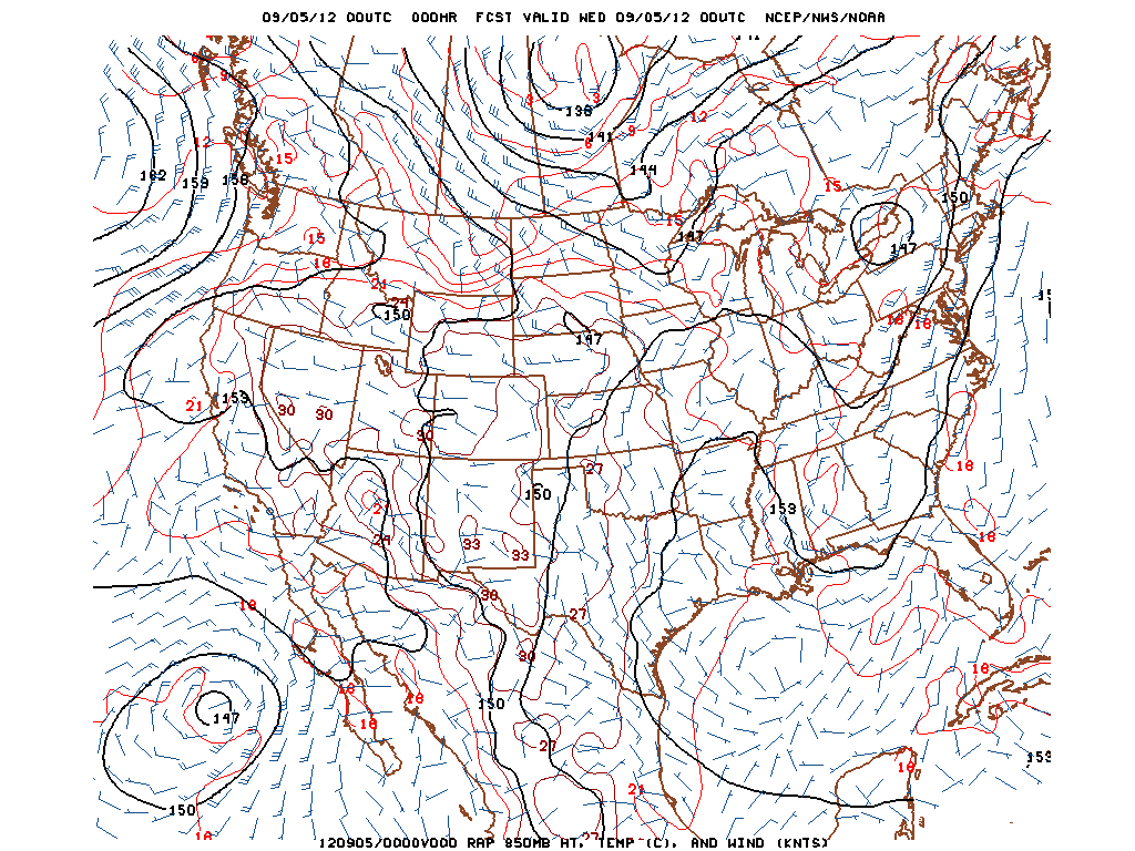
RAP 850mb Analysis for 00z Wednesday, September 5th or 8pm EDT Tuesday, September 4th 2012.
“Tornado Warning” has always been an ominous phrase. When you hear those words, things generally tend to get a little more serious. On Tuesday, there were more than three Tornado Warnings issued throughout the state of New Jersey, beginning in the afternoon and continuing into the evening hours. Although the area did not see much in the way of severe weather reports in a quantitative sense, there were several reports of low-level mesocyclones, funnel clouds, and even tornadoes in the general extreme Eastern PA and NJ areas. In hindsight, this was actually a pretty good setup for low-level mesocyclones and tornadoes, and I’ll explain why.
Synoptically, we had a surface low that slowly deepened to around 1006mb located in Western Upstate New York, along with a closed 850mb low located in the same area. This placed our area in a pressure trough, and also resulted in a warm front that moved to the north across our region. Warm fronts are generally a better lifting mechanism for rotating thunderstorms than cold fronts. This closed 850mb low helped to provide a nice low-level jet, as 850mb winds were around 30 knots in most locations.
Additionally, there was some helicity as well, which is an indicator of rotation in the low levels of the atmosphere. What is also interesting to note is the light SE surface winds, and the importance of that will be explained in a bit. Click “Read More” below to read the full article..
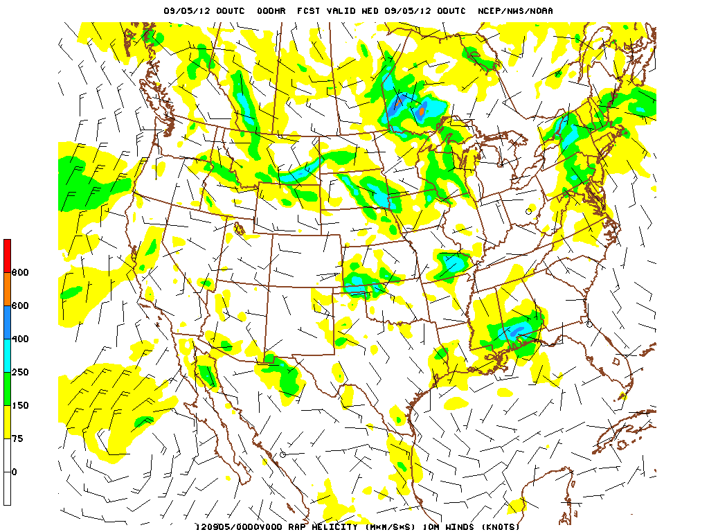
RAP Helicity and 10m winds, valid 00z Wednesday September 5th or 8pm EDT Tuesday, September 4th 2012
When you combine the light surface winds out of the SE, with strong, 30 knot winds at 850mb coming out of the SW, that leads to lots of both speed and directional shear in the low-levels of the atmosphere, which leads to the low-level rotation that is necessary for mesocyclone and tornado formation. Additionally, the speed shear helps to keep the updraft and downdraft separate, leading to storms have time to develop, become strong, and maintain their strength, as opposed to raining themselves out. This image was valid for around 9pm, but it illustrates the point quite well, as the shear from 0-1km was around 25 knots in the areas where the storms formed, which is quite sufficient for low-level rotation.
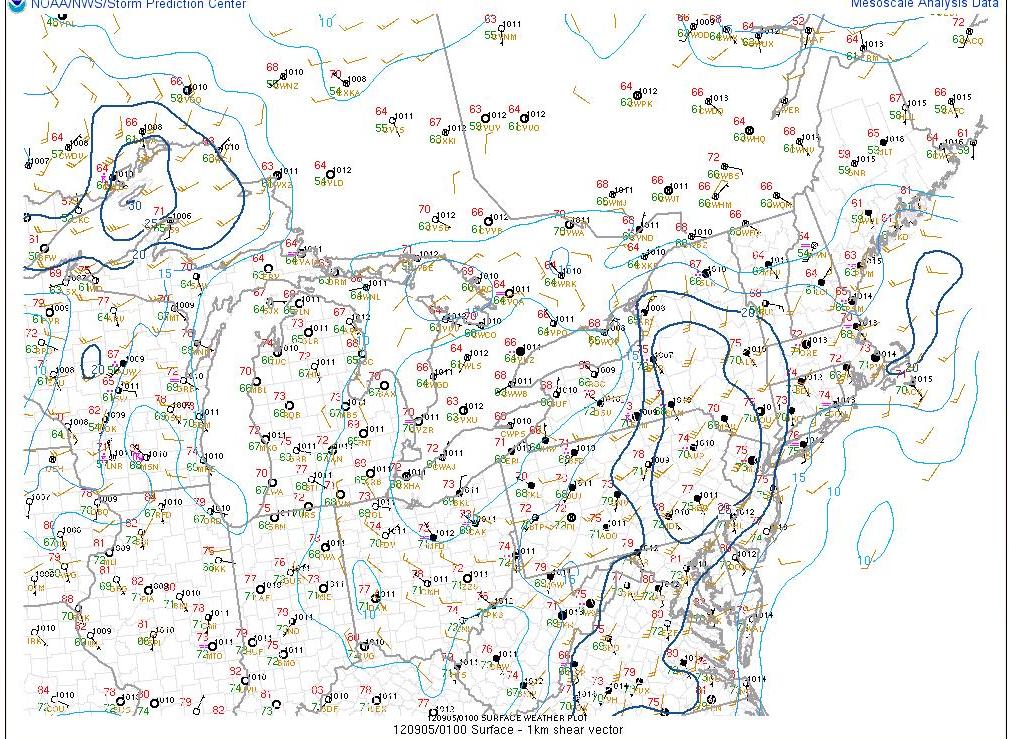
Storm Prediction Center surface analysis (underlay) and 0-1km helicity (overlay, contoured) valid 0100z Wednesday September 5th, 2012.
With the cloud cover, it would be intuitive to assume that there was not much in the way of instability, as generally, it is surface heating from sunshine that helps to create surface-based instability. However, all of the low-level moisture that was around helped to generate low LCL heights, meaning low cloud bases, which are critical for getting rotation to actually reach the surface. It also helped to generate instability, as CAPE values were around 1500-2000 J/KG across New Jersey.
As one can conclude, we were able to juxtapose 1500-2000 J/KG of CAPE, a pressure trough, a warm front, which provided the lifting mechanism sufficient for developing rotating storms, a low-level jet, which provided good speed and directional shear into our area all into one location, which happened to be in New Jersey. The instability was not as strong as you headed further west.
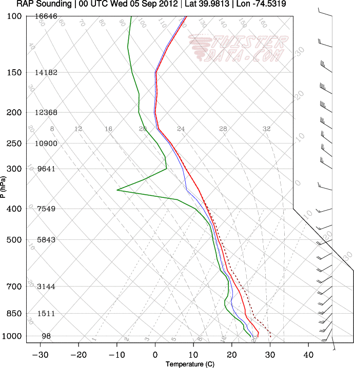
Now, what about the lack of severe weather in any other sense? This can be explained by the fact that the winds above 850mb, especially at 500mb, happened to be quite weak. Thus, there was pretty much no shear once you got above the 850mb level. When you also combine that with the fact that the lapse rates were not that steep to begin with, this means that any updraft that got past 850mb had no chance to really cause any more sufficient vertical growth. Without strong vertical growth to a cloud, there will not be any ice crystal formation in it for hail, as the cloud tops are not cold enough when they are so low. Additionally, the low cloud tops also mean that any downdrafts will be slower, as they have less time to accelerate before hitting the ground. This is why there will not be much in the way, if at all, of straight-line wind reports, and instead the wind reports will most likely come from tornadoes. An initialized sounding from the 00z RAP in Western NJ shows this quite well.Fortunately, the modest lapse rates and non-existent mid-level shear helped to tame the outbreak of severe weather somewhat. But some of today’s storms were certainly nothing to sneeze at!
Leave a Reply
Want to join the discussion?Feel free to contribute!