-2")
Sandy Postmortem: Worst Case Scenario?
As we continue the clean-up efforts and power restoration across the tri-state area, let’s take a moment to reflect on the rarity of the storm we just experienced. Over the past couple hundred years, we have seen plenty of hurricanes run up the East Coast, but only a few were comparable to Sandy in terms of her track. What made Sandy so devastating was the angle at which she approached the coast. An extremely anomalous synoptic-set, with strong blocking to our northeast, and an upper trough digging into the mid atlantic, essentially captured Sandy, turning her NW. The upper jet streaks to her south (over the Bahamas) and to her west (over the Appalachains) placed Sandy in a favorable position for intensification – being in the left exit region of one jet streak and the right entrance region of another jet streak. These regions are conducive to upward motion/rising air. Thus, Sandy maintained category 1 intensity (nearing Cat 2 while over the Gulf Stream), and remained a formidable hurricane upon landfall near Atlantic City, NJ, with sustained winds around 80mph.
The largest storm surge in association with hurricanes is always in the right front quadrant of the cyclone. In other words, it occurs to the north/east of wherever the hurricane makes landfall. What made this event so devastating for the Jersey Shore and NY shore was the incredible storm surge from Sandy. Since she made landfall in southern NJ, the worst storm surge was funneled northwest, into the NJ coastline, Raritan Bay, NY Harbor, and Long Island. Surge reached 13.8 ft approximately at Battery Park NY – a record breaking value. Many houses were washed away from the surge.
The strongest winds are also generally located in the right front quadrant of the hurricane – which in this, also occured over eastern NJ, NYC and Long Island. So our area experienced both horrendous storm surge and strong winds. Meanwhile, the heaviest rains tend to occur to the left of the storm track, and we saw that with the 5-10″ rains in PA, DE, MD, and VA. They did not receive as much damage though, due to weaker wind speeds, and virtually no surge. Winds are counter-clockwise around low pressure, so folks on the coast south of Sandy’s landfall — DE, MD, VA, had NWLY winds / offshore flow and thus substantially less storm surge.
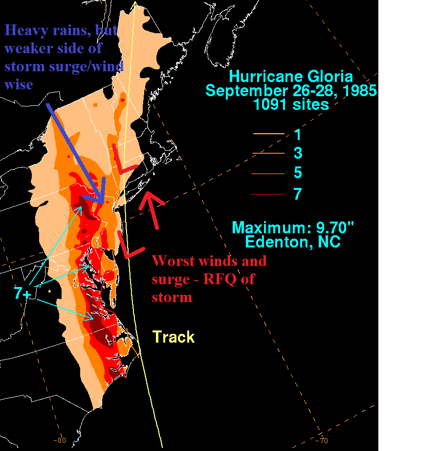
Let’s look at a handful of past storms for comparison purposes. Below is Hurricane Gloria of 1985. Note the storm track slightly east of due north into Long Island. Therefore, the strongest surge and wind occurred over Eastern LI, and New England. Our area saw big rains and wind damage from 60mph+ NW winds. But that wind was generally pushing water offshore, not toward the coast as we saw with Sandy.
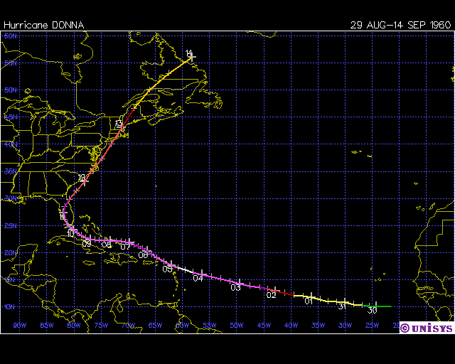
Here is Hurricane Donna of 1960. The track w/ this storm was SSW-NNE, so even less storm surge impact for NYC, NJ coast, although there was still significant damage. However, one can see the right front quadrant of the hurricane was E Long Island, and SE New England, as is usually the case with East Coast hurricane events.
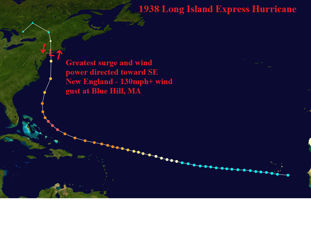
The Long Island Express hurricane of 1938. Major hurricane landfall – Cat 3 – into Long Island. Winds gusted well over 100mph in New England due to their orientation east of the storm’s track. We saw major impacts due to our closeness to the path, but again, the storm surge and winds were not worst case since the NYC metro area remained on the western side of the hurricane.
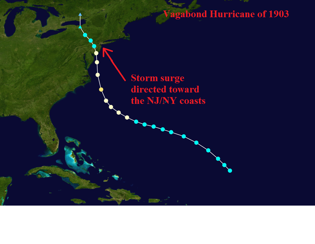
Going back further in time – the 1903 “vagabond” hurricane. This is pretty much as close to Sandy’s track as we can get. NNW moving categor 1 hurricane into southern NJ, with sustained winds of around 80mph at landfall. Here we can see the largest surge is directed toward the NJ coast. Damage totalled 8 million in New Jersey, which was a huge number for those days. Keep in mind infrastructure was world’s apart from the current New Jersey. Winds reached 65mph in NYC with the 1903 hurricane, with tropical storm force winds extending 500 miles north to the Maine coast.
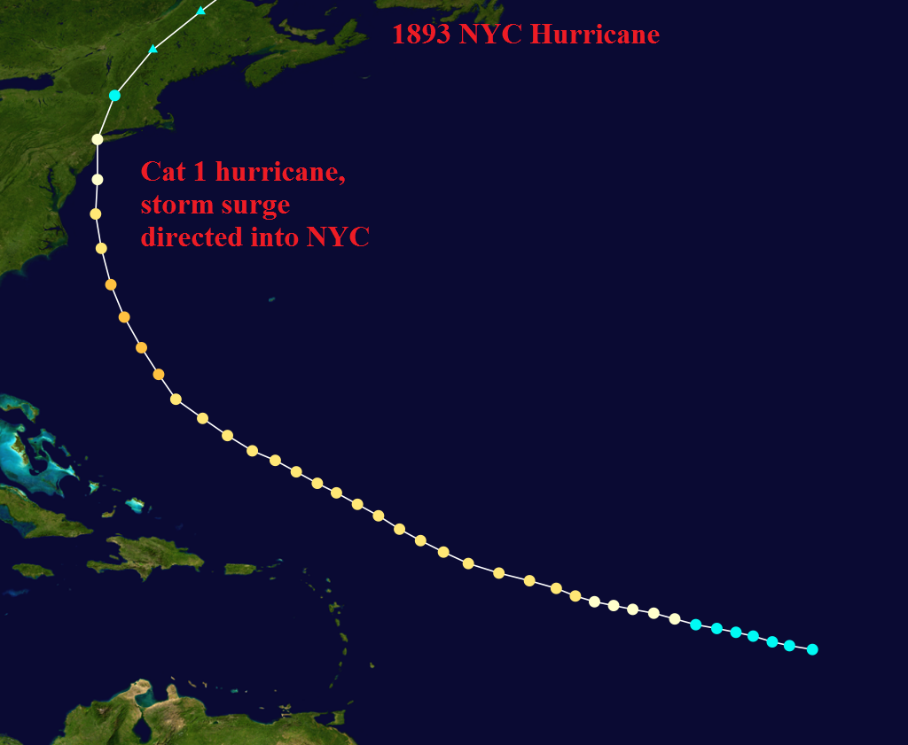
The 1893 hurricane made landfall directly over NYC, at category 1 intensity, 85mph sustained winds. Reports indicated that hundreds of trees were uprooted in Central Park, implying probable wind gusts near hurricane force. Again, NYC, like NJ, was essentially a forest in these times, so the damage is not comparable, but the storm track/intensity certainly is similar.
Now the 1821 hurricane is arguably the most intense storm to ever make landfall in the NJ area. It was likely propagating northward at about 35mph, which allowed the hurricane to maintain category 3 status once into NJ/NYC. Surge reached 29ft along the NJ shore (imagine that today), and “only” 13ft at Battery Park, which does not beat Sandy’s 13.8ft. This could be because of the track. Note the storm passes to the SE of NYC, so the highest surge likely went into Long Island’s south shore. That demonstrates the importance of storm track wrt devastating storm surge. Either way, we’ve seen a few storms comparable to Sandy in the past 200 years, and there’s no doubt Sandy was a 1 in 100 year event. Given infrastructure in NJ/NYC is significantly further along than any of the years noted, it’s also expected that Sandy will be far, far costlier than any hurricane, ever, in the tristate.
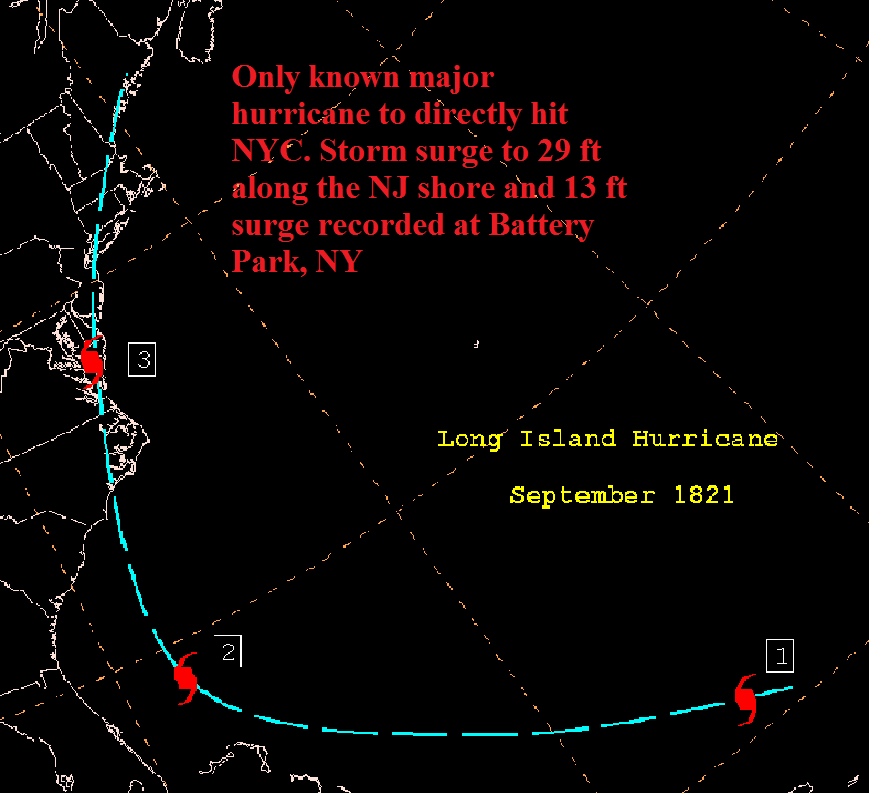
Accounts say that there was a more intense storm (than 1821) that struck NY/NJ in the 1200-1500 time period based upon paleotempestological research, but one can see how rare it is to have a hurricane directly make landfall on the NJ coast or in NYC.
Sandy’s track, NW into NJ, made the storm surge record-breaking, and her interaction with the trough resulted in a hybrid-transitioning low that allowed the wind field to spread out 150-200 miles upon landfall. Thus, hurricane force gusts were recorded over a large area in NJ, NYC, and LI, in contrast to most east coast hurricanes that have a more concentrated wind field. Overall – this was a horrific storm for the region and let’s hope we don’t see another for a long, long time.
I don’t see how the 1821 track, based on historical charts, support it being a Category 3 hurricane in NYC. Look at all the land it goes over from Central, NC up the coast, including VA, DE, NJ. If it were a Cat.3 hitting NC I would honestly think it’s a Cat.1 at most when hitting NYC.
If there was no ULL sheer to the west influencing the storm, and if it had a quick forward motion, then maybe it would come into NYC as a weak Cat.2.
Nick