Storm to bring myriad of threats through Thursday

NAM Model showing a significant storm system impacting the area Wednesday Night into Thursday, with snow inland, a wintry mix across some suburbs, and rain/wind near the coast.
A powerful storm system which brought torrential rains, heavy snow, and severe weather (including several strong tornadoes) to the Central United States is on the move this evening, heading northeastward towards the Mississippi Valley and eventually the Northeast States. The storm will eventually re-develop to a position near New York City by later Wednesday Night, bringing with it the potential for significant precipitation. Cold air entrenched in the low levels of the atmosphere will initially allow for snow across the interior. However, a rapid change is expected as warm air advection begins at all levels of the atmosphere — mid levels first, with precipitation changing to rain at the coast very quickly. The wintry precipitation should hold for several hours across inland locations, but snow could mix with sleet/ice pellets. By the time the storm is over, all areas will have changed to rain — and the threat for strong winds will exist near the coast as the heaviest precipitation moves through late Wednesday Night into early Thursday Morning. Below, we’ve detailed the potential threats and the timing for each one.
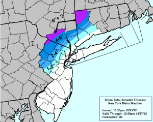
 Snow: Many areas could begin with some snow flakes, but the storm will certainly be characterized by a changeover to rain. This change will occur gradually, and will be faster to occur near the shore and in the city and slower to occur inland especially in the higher elevations. For a few hours, the immediate suburbs could see a flip from snow to sleet before the changeover to rain. As is the case with amny systems like this one, the mid level warm air advection will win out before the low levels cool. So precipitation will likely flip to sleet across many areas before turning to all rain. Inland, across the high elevations of Northwest NJ, Southeast NY and Connecticut, a more prolonged period of snow and sleet could lead to light to moderate snowfall accumulations. Precipitation is eventually expected to flip to all rain throughout the areas, becoming heavy at times. To the left, we’ve attached our storm total snowfall forecast which is valid from this evening through Thursday Night.
Rain: The potential exists for periods of heavy rain, especially near the coast during the height of the storm. Forecast models are indicating the potential for over 2 inches of precipitation throughout much of the area by the time all is said and done. Some localized flooding cannot be ruled out, especially as these totals could come in a relatively brief period of time.
Wind: Forecast guidance also indicates the potential for strong winds and dangerous wind gusts, especially near the coast. As the low pressure passes close to the forecast area Wednesday Night into Thursday, a very strong low level jet will pass nearby bringing with it strong southeast winds. The winds in the low levels of the atmosphere, just above the surface, will be especially strong thanks to this low level jet. If lapse rates can steepen and these winds can mix down, the potential exists for gusts over 60 miles per hour. The strongest winds appear likely near the New Jersey, New York, and Connecticut coasts…especially the Jersey Shore, Long Island, and New York Harbor.
We encourage you to stay tuned for the latest updates on this storm system as it approaches the area. Our Facebook and Twitter accounts will have the latest up to the minute information as well.


