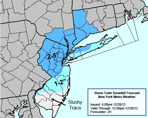
-2")
Cold, blustery weather to close out 2012

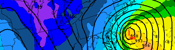
NAM model showing very cold temperatures at 850mb (purple is -10 F and below) in the Northeast Tuesday Night.
It has been a bit of a wild weather year. Alright, that might be putting it lightly. It has been a wild, wild weather year. Our area has experienced some extremely strong, damaging storm systems with tremendous variance in weather over short periods of time. After making it through a snowstorm just a few days ago with only light snowfall accumulations (the bigger totals were relegated to New England), we’ll be able to end the year on a relatively calm, quiet note. The pattern in the wake of the storm system will feature colder than normal weather and some blustery winds, but for the most part doesn’t look to feature any strong storms or high precipitation events for the next week or so.
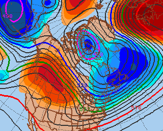
GFS model forecast 500mb height anomalies at 120 hours from 12/30/12 (Valid 1/4/12)
The main culprit will be a developing ridge out west, in tandem with a Polar Vortex to our north over Southeast Canada and extending into the Northwest Atlantic. The image to your left (GFS Ensemble 500mb height anomalies valid Friday 1/4/13) displays the pattern which models suggest will be in place for the near future. West coast ridge (+PNA), East coast trough and plenty of cold air in Southeast Canada. At first glance, you might think the pattern could be favorable for cold (which it is) and potentially snow on parts of the East Coast and Northeast including the NYC Area. However, the main trough will remain in the Northwest Atlantic…which means that pieces of energy/atmospheric disturbances will race through our area…but won’t amplify and develop any storm systems until they are far off to our east. So, while there will be continued shots of cold air and the potential for light snow/snow showers at times…significant precipitation will avoid our area barring any unforeseen changes to the general pattern.
Here’s the forecast for the next few days, but you can check out the long range details through Day 7 in our Forecast Brief and Forecast Discussion. We wish you all a happy and healthy New Year!
Monday: Partly sunny, blustery. West winds continue gusting near 20 miles per hour at times, but won’t be nearly as strong as they were on Sunday.
New Years Eve (Monday Night/Tuesday Morning): Partly cloudy and cold with temperatures falling into the 20’s and low 30’s. A slight chance of snow showers throughout the area. No accumulation expected. Occasionally blustery winds.
Tuesday: Partly cloudy, a bit warmer with high temperatures in the 30’s to near 40 in urban locations and places near the coast. Blustery west winds continue especially during the afternoon.