-2")
Active pattern continues, potential snowstorm looms this weekend
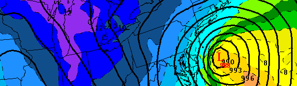
European forecast model forecast a significant low pressure system off the NJ Coast on Saturday evening. If the storm develops, it could bring snow to much of the area.
While a powerful storm was ongoing throughout the New York City area this Thursday Morning, medium to long range meteorologists were forced to also watch the latest modeling data for an upcoming system this weekend — one which could potentially bring a snowstorm to much of the area. A strong disturbance in the mid levels of the atmosphere will make its way towards the Mississippi Valley by the end of the week, while a second piece of energy from the northern jet stream begins to move southeast from Canada into the Ohio Valley. Forecast models are struggling with the interaction between these two features — and the exact details of how they interact will determine what occurs. We’ve laid out the scenarios below:
Scenario 1: Should the two pieces of energy interact (or “phase”), a strong surface low would likely develop off the Mid Atlantic and Northeast Coasts Saturday into Sunday. A rapidly developing cyclone would then bring the potential for moderate snows across most of New Jersey, New York, and Connecticut with the potential for heavier snows near the coast and on Long Island.
Scenario 2: If the two pieces of energy don’t interact, or do so later or in an unorganized fashion, a weaker storm system will likely develop. The later developing, weaker system will save the area from a strong storm system and heavy precipitation. Instead, light snow would be possible in many locations as the storm system passes by and then strengthens well off to our northeast.
The trend on the forecast guidance, over the last 24 to 36 hours, has been stronger and farther west as a result of more phasing between the two features and a better initial setup (including a stronger/more organized initial shortwave and trough and more robust northern stream shortwave). We’ll be watching carefully over the next day or so — and in that time we should begin to get more answers to the questions we have regarding this storm going forward. We’ll be keeping you updated along the way.
Leave a Reply
Want to join the discussion?Feel free to contribute!