-2")
Major Noreaster could impact area beginning Friday
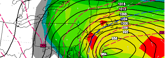
European forecast model, showing a very strong low pressure system off the coast on Friday evening. In addition, the model is forecast significant snowfall for a large portion of the area through Saturday.
In what surely looks to be a dramatic break in a dry, quiet weather pattern…forecast models are honing in on the potential for a significant Nor’easter beginning late this week on Friday and continuing into this weekend. The complicated weather pattern surrounding the system has wreaked havoc on forecast models, and has left forecasters struggling to put together the pieces of the puzzle which could ultimately end in either a nor’easter (and potential blizzard in New England), or a more tame system with light rain/snow mix. Below, we attempt to detail the threat and break down the potential scenarios — while continuing to analyze the new data this afternoon.
Why is the storm developing, what’s going down? Two pieces of mid-atmospheric energy are poised to “phase” over the Mid-Atlantic states on Thursday into Friday. The moisture-laden piece of energy from the southern jet stream is heading northward from Southeast states, while the energy from the Northern jet stream will dive southeast through the Ohio Valley. The exact timing and interaction between the two features will have dramatic impacts on the exact track and intensity of the storm system. A quicker, stronger phase will result in a much more impactful storm with the potential for widespread significant snow, wind and coastal flooding.
What are the potential scenarios we’re dealing with? There are several, and the forecast models are still struggling with the storm system. As mentioned above, a stronger and cleaner phase between the two disturbances would result in a faster deepening storm system off the coast. This becomes important, especially for our area with the cold air waning by the time the storm begins to form. The rapidly strengthening storm off the coast develops a cold conveyor belt, and draws in a significant amount of cold air in addition to dynamically cooling the atmosphere with heavy precipitation. Should this scenario unfold, widespread significant snowfall would be likely..and the intensity and track of the storm would also bring the potential for high winds and coastal flooding.
Should the two disturbances phase later, or less “cleanly”, the storm would likely not deepen rapidly until it was a bit farther to our northeast. As a result, impacts would be slightly lessened, but the potential would still exist for a mixed precipitation event ending with possibly significant snowfall. Finally, an outside chance still exists that the storm will escape to the northeast with minimal impacts — but the chances of that occurring are becoming dramatically less over time.
When will we know more details? We’re awaiting further data this afternoon and evening. After that time, we will likely have a much better idea as to how the storm will shake down later this week and weekend. At that point, later tonight the forecast models should be able to sample the pieces of energy very well and the eventual solutions should be more accurate. We are expecting to have a timeline/event detail post up later this evening, with snowfall/impact amounts forecast by Thursday morning. Stay tuned for details especially on our Facebook and Twitter accounts.