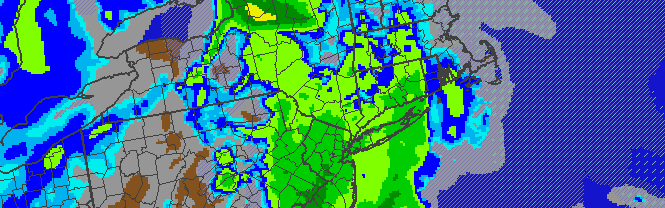
NAM model showing prolific snowfall totals throughout the area by Saturday morning. White values represent 12 inches or more, red values represent 16 inches or more, with darker red indicating a forecast for over 24 inches of snow.
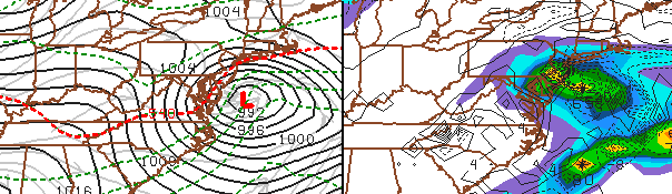
A powerful nor’easter, developing off the coast of the Mid Atlantic states Friday into Saturday, will impact the area with heavy wintry precipitation and strong winds, with the potential for widespread prolific snowfall amounts. Forecast models have come into agreement on the track and intensity of the surface low, with the storm tracking off the coast of the Mid-Atlantic states and rapidly deepening before moving towards the 40/70 Benchmark by Saturday. As two pieces of atmospheric energy “phase” over the Mid-Atlantic states, significant precipitation will move up the East Coast…falling as a rain/snow mix and eventually very heavy snow throughout the area. Although it remains uncertain where the highest amounts will fall exactly, the potential for a foot or more of snow exists throughout a large portion of the forecast area. We break down the storm system below.
Why is the storm system developing? Two pieces of mid-atmospheric energy are poised to “phase” over the Mid-Atlantic states on Thursday into Friday. The moisture-laden piece of energy from the southern jet stream is heading northward from Southeast states, while the energy from the Northern jet stream will dive southeast through the Ohio Valley. The exact timing and interaction between the two features is key, and forecast models have trended towards a more robust phase and the potential for a very strong storm system developing as a result. In addition, a strong high pressure system to the north will supply additional cold air once the storm system begins to deepen off the coast.
What kind of impacts can we expect? Heavy snow and strong winds will be the main threats, but coastal flooding and ice/sleet may also become issues during the storm system. Impacts could begin as early as Friday morning with rain/snow falling throughout the day. Significant travel impacts are anticipated throughout the area including road travel and airports.
What kind of snow accumulations are expected? We are expecting 8-14 inches of snow throughout the majority of the NYC Area and Northeast New Jersey. Farther to the south, a gradual decrease in amounts is expected once one nears Trenton and Central NJ. Farther north and east, more prolific snowfall totals are likely..especially over Long Island and Connecticut, where upwards of 18 inches of snow is becoming more likely with time. On the top right of the page, a widget displays our latest snowfall map which will be updated Thursday Evening and again Friday morning.
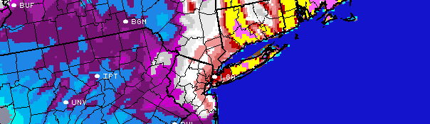
When will the storm start, end, and when will the worst be? Snow and rain could begin as early as Friday Morning throughout the area and will continue through Friday afternoon. By mid afternoon on Friday, precipitation is expected to become heavier and steadier. Southern and Central NJ will see a transition to rain/sleet by this time. However, areas farther north over Northern NJ, NYC, CT and Long Island will begin to see very heavy snowfall. After sunset on Friday, and continuing through the overnight, very heavy snow is expected throughout all of Northern NJ, New York City, Long Island, and Connecticut. The snow will continue, heavy, through Saturday.
Strong winds, very heavy snow with significant blowing and drifting is possible. Significant delays or closures at airports are a certainty. Roads will become difficult to travel and we recommend that you stay off them under all circumstances. Visibilities could drop to near zero at times during the heaviest snow.
Stay tuned here, and on our social media network accounts for up to the minute details on the system as it approaches.
-2")