-2")
Icy interior to begin Monday, another potential snowstorm midweek
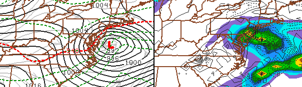
GFS Model showing a snowstorm impacting our area Wednesday Night into Thursday morning. Forecast models continue to struggle with handling the disturbance, and the eventual track will determine the impacts the storm may have on our area.
Monday Morning Brief: A Freezing Rain Advisory is in effect for parts of interior New Jersey, Southeast New York, and Connecticut through Monday. A period of light frozen precipitation is expected overnight Sunday into Monday. Travel may be slick/slippery and icy in these areas during the early morning rush hour on Monday — so be careful! The advisory does not include the NYC Metro.
An active weather week is ahead of us, and it begins with the potential for some freezing rain/wintry mix in the interior on Monday morning. This short lived wintry precipitation will be followed by a period of light rain during Monday afternoon, and clearing thereafter with a return to normal temperatures. Lows in the 20’s and 30’s are expected again by Monday Night into Tuesday, with high temperatures struggling into the 40’s on Tuesday. Despite the sun, blustery west winds will keep Tuesday feeling wintry with whatever snowpack remains (possibly a good bit especially in areas that received prolific snow amounts a few days ago).
Focus will then turn to another potential winter weather event, which forecast models are hinting could impact the area beginning Wednesday Night and continuing into Thursday. Although this event looks much more “moderate” than the Blizzard just a few days ago, some guidance still indicates the potential for several inches of snowfall in some areas should the storm track far enough north to impact the area. Others, however, keep the storm suppressed far to the south with minimal impacts. We’ll be keeping a close eye on it — and should have more confidence in the eventual track of the storm system (and resulting impacts) by Monday evening. Stay tuned here, and to our Facebook and Twitter accounts for updates throughout the day and night!
Leave a Reply
Want to join the discussion?Feel free to contribute!