-2")
Dreary Tuesday ahead of approaching cold front
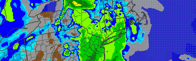
NAM Model’s simulated radar, showing precipitation lingering over the area through Tuesday Night. Clearing is expected behind a cold front on Wednesday.
Less than ideal weather has overtaken the area this afternoon, and unfortunately looks to stick around through the evening and into the overnight period of Tuesday Night into Wednesday morning. As a cold front passes the area, clearing is expected by Wednesday with the return of cooler temperatures. Until then, southerly winds will promote temperatures around 5 degrees above average with plenty of clouds and showers int he area. Precipitation started as snow/wintry mix across the far interior and northwest suburbs but has since transitioned to a cold rain — which is expected to continue through the evening.
The mid-week forecast looks to feature more sun, but colder temperatures and a stiff breeze on Wednesday. High temperatures will barely reach into the lower 30’s on Wednesday and Thursday in the city, and should stay below freezing inland. The next system of interest doesn’t come onto the forecasting radar until Friday, and it looks to feature some frozen precipitation but a transition to mostly rain. We’ll keep you updated. For now, here’s the short term forecast:
Tuesday Night: Showers likely, with a low temperature near 30. South winds turning west and increasing to 10 to 15 miles per hour. Clearing by the late-overnight.
Wednesday: Clearing and sunny. High near 33. Cold, with blustery west/northwest winds near 20 miles per hour.
Wednesday Night: Mostly clear with lows in the teens to 20’s. Cold. Still blustery, with west winds 10 to 15 miles per hour.
Stay tuned to our Facebook and Twitter accounts for up to the minute updates on the area’s weather!
Leave a Reply
Want to join the discussion?Feel free to contribute!