-2")
Update: October NAO and what it means for winter
As we have alluded to in previous articles, the weather pattern across the globe is currently undergoing changes. A lot of this has to do with recurving Typhoon Wipha, as the large storm generated a trigger to produce a large ridge ahead of it. This helps to create a more amplified pattern, slowing things down. A slower global pattern is what tends to lead to more blocking, and the blocking that we are seeing this month could be a very important player as we head towards winter.
The reason it’s important is because there is a significant correlation — especially recently — between a -NAO in October and a -NAO during the following winter. One reason among many for this is because a -NAO pattern will often establish itself in October, relax a bit during November, and then re-establish itself during the winter. Our previous article highlights the detailed research and correlations, which will help you contextualize what is being written in this article.
The prudent question to ask now would be how the NAO has been doing so far, and if it will stay negative for the rest of the month.
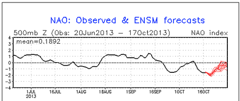
The NAO has been negative this month, and should continue to remain negative for the rest of the month. The black line represents the observed values, and the red lines represent the forecast values from the GFS ensembles.
The above image from the CPC shows that the NAO has been predominately negative so far this month. After starting off negative, it rose to neutral last week, before plummeting again to a solidly negative value. It is this plummeting of the NAO that will eventually lead to a pattern change to colder weather starting sometime next week. Although the NAO is expected to slowly rebound towards neutral, it is expected to stay negative, which would lead the October NAO value to probably average right about -1.00, or even slightly lower. That is certainly negative enough to fit the correlation for winter blocking.
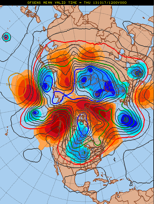
The current weather pattern shows the blocking regime very well. Also note the ridging poking through Alaska — a -EPO pattern. This also favors cold, and it is the -EPO and -NAO combination that leads to our coldest and snowiest winters.
The current 500mb pattern shows strong positive height anomalies poking into the northern Atlantic and Greenland, which is a sign of the -NAO. Also note the strong ridging poking through Alaska, which is a -EPO pattern. This is what helps to dislodge the cold from the Arctic into the southern Canada and the United States, and the -NAO block helps to keep it there. Over time, the cold will build and dive southeastward towards the eastern United States, giving the area solidly chilly weather starting sometime next week.
The point of this is to show that it is not just the NAO that leads to cold and snow. The NAO is obviously a major piece of the puzzle, and the -NAO in October is a good sign for winter-lovers heading forward. But without additional help from the Pacific pattern, it is not a guarantee that our area sees cold and snow. Last winter saw solid blocking regimes in the North Atlantic, but the Pacific pattern was relatively poor; thus our only major snow event being the February 8, 2013 snowstorm, which gave Long Island and New England historical snowfall.
Regardless, however, it is pretty clear that the NAO this month will be negative, which gives a pretty strong chance that this upcoming winter will have a negative NAO. And our snowiest winters tend to have a negative NAO. Remember, though, that there are other pieces to the puzzle for a snowy winter; but having the NAO potentially on your side is never a bad thing — if you like snow, of course!
Leave a Reply
Want to join the discussion?Feel free to contribute!