-2")
Pattern overview: Some ups and downs, but overall warm
After a chilly few days, temperatures are rebounding, and this should continue to be the case. Thanks to a -PNA pattern, which favors a trough in the western half of the country and downstream ridging in the eastern half of the country, as well as no -NAO nor -AO to keep that ridging at bay, our temperatures have moderated nicely. Temperatures will rise into the mid and even some upper 60s on Wednesday and Thursday out ahead of that trough, before a cold front comes through on Thursday night with a few showers and chilly weather for Friday and Saturday, but nothing too unseasonably cold.
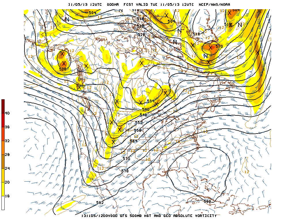
The initialized GFS from this morning shows a positive NAO, positive AO, and negative PNA pattern — all favoring a ridge in the east.
As one can see, the initialized GFS image from this morning shows very low heights in Greenland, leading to a positive NAO, low heights close to the Arctic, leading to a positive AO, and a trough in the west, leading to a negative PNA. This all favors a ridge in the east, which is clearly shown. And although there is a ridge in the Pacific, its amplitude gets cut-off by low heights in Alaska, which is a +EPO pattern. This means that all the cold air gets bottled up in the Arctic, and cannot get sent down to the United States. Instead, any troughs tend to contain more Pacific-oriented air, so even the trough in the west is not all that impressive. Since there is not a whole lot of cold air associated with the trough, the temperature gradient is weak, and any storm that forms along it will not be all that impressive. Also, the strongest height gradient is currently in the midwest, so any storm would tend to take that track and mostly miss our area.
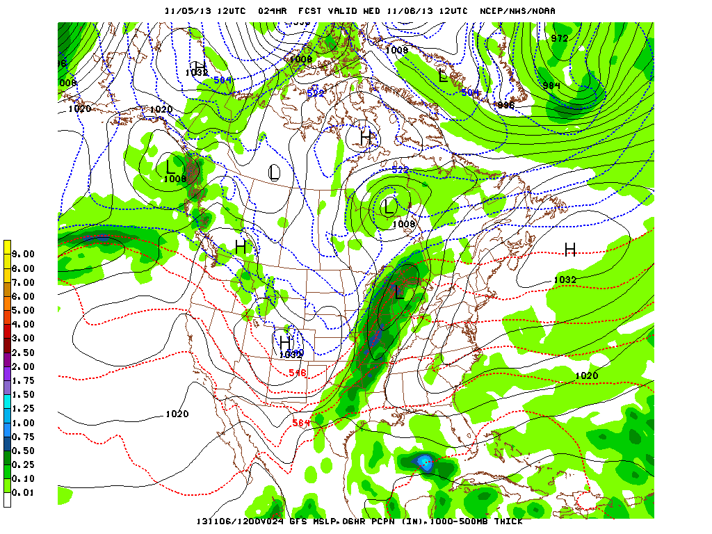
A weak storm system will traverse the midwest on Wednesday, as relatively benign temperature gradients prevent it from being too impressive.
As one would expect based on the orientation of the height gradients, a storm system forms in the Midwest. But thanks to a lack of true cold air, the temperature gradient is weak, leading to the storm not becoming that strong. Snowfall on the cold side of the storm in the Midwest appears to be limited because of this; though some showers and thunderstorms will develop on the warm side of the storm system in the Mississippi Valley. Meanwhile, our thicknesses are quite high and temperatures will rise into the 60s tomorrow!
The aforementioned storm system will drag along a cold front, but with the relatively weak temperature gradients, moisture will be limited. The dry pattern continues, for now.
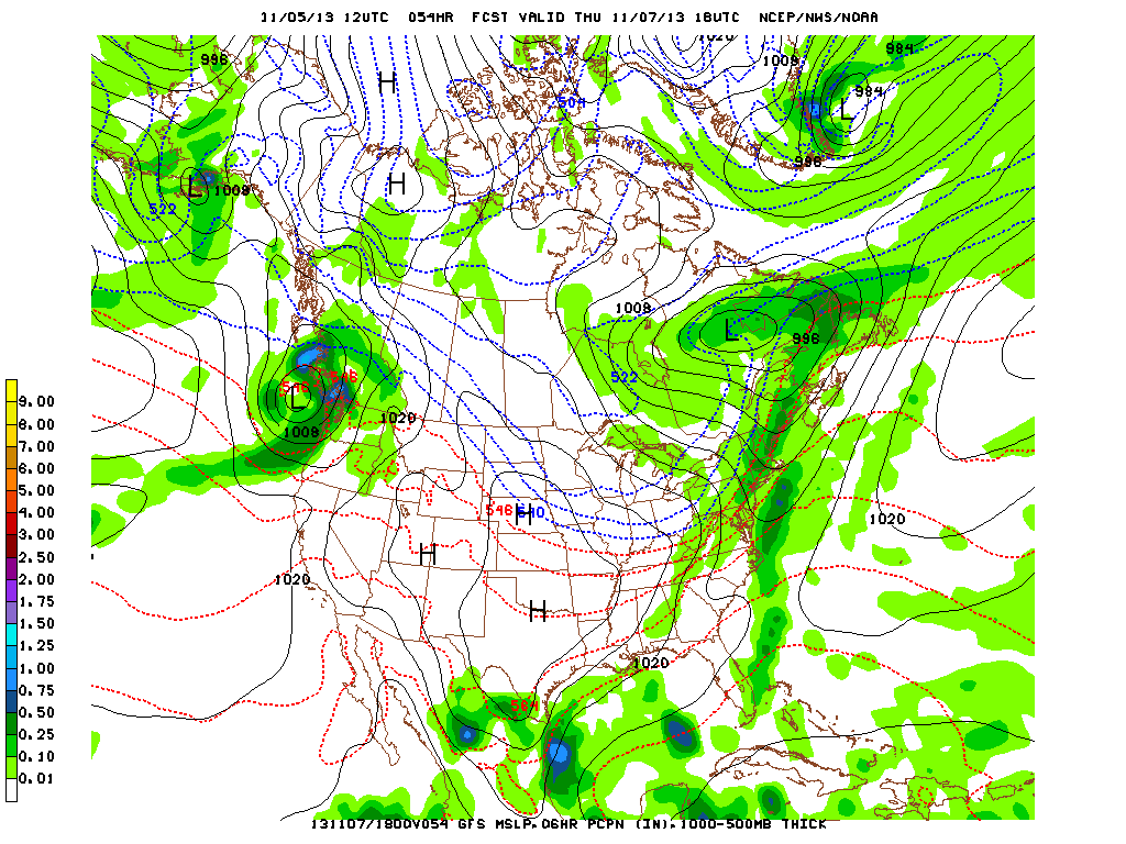
Moving on into Thursday, the storm plows into Quebec, not having strengthened all that much, and it drags a cold front to its south. This is when we can expect some rainfall — Thursday afternoon and Thursday night. However, without the true cold air source to fuel the storm and the front, moisture will be relatively unimpressive; plus the fact that the storm’s track was unfavorable for moisture in our area to begin with. So although some rain can be expected, nothing too substantial should result, meaning our dry pattern will continue.
Once that front crosses, our temperatures will cool down for Friday, with highs only in the lower 50s, and low temperatures hitting the freezing mark again on Friday night. However, given the +AO, +NAO, and -PNA pattern, any cold shot will only be temporary and not all that impressive. As stated before, the cold air source is relatively meager, and once a cold front does move through, moderation takes place as more ridging moves along. Temperatures could hit the 60-degree mark again by Sunday.
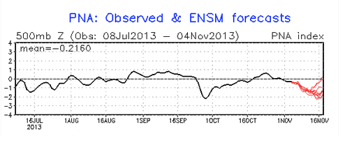
Ensemble data shows the negative PNA pattern continuing, favoring a trough in the west and a ridge in the east.
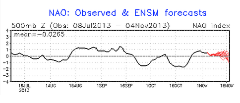
Ensemble data shows the NAO remaining generally positive, which will mean that any ridge in the east will not be able to get “squashed”, keeping things generally warm. But the trend towards going to neutral mid-month does warrant some interest.
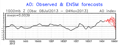
Ensemble data shows the AO being very positive, meaning cold air gets bottled in the Arctic. But the trends towards neutral mid-month do warrant some interest.
Are there any signs towards the pattern changing? To some extent, yes. The negative PNA pattern looks to remain for the foreseeable future, which favors a trough in the west and a ridge in the east. The AO and NAO will be positive, helping to maintain that warmth — but they do head towards neutral mid-month. Does this mean a cold air source could head to the United States?
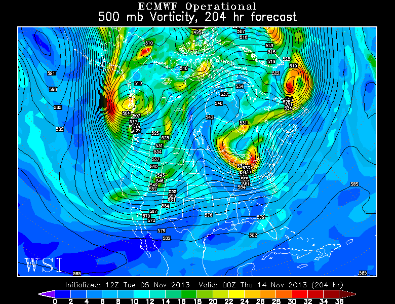
The European Model valid for the 14th shows a record-blocking event near the Aleutians, which could favor cold being delivered to the United States. However, due to the negative PNA, that may be the western half of the country rather than the eastern half. Image credit goes to the WSI Model Lab.
As we head towards mid-month, things begin to get interesting. Look at that huge ridge near the Aleutians (west of Alaska). 500mb heights are upwards of 594-597 decameters! That is extremely impressive, and for every strong ridge, there must be a strong downstream trough. This means that troughing can be found in western Canada, which will help to dislodge some of the cold from the Arctic — thus explaining the AO heading towards neutral. This upcoming trough is much more impressive than the one we are currently seeing. However, since the PNA looks to remain negative, the coldest air looks to be relegated to the west coast, meaning no sustained cold is likely for the east in the foreseeable future, leading us to believe that November will average warmer than normal.
That being said, the fact that a cold air source will be dislodged from the Arctic thanks to that record Aleutian blocking, and the fact that the AO and NAO may head towards neutral and maybe even negative at times — that trough will try to gradually shift east and perhaps any southeast ridging will be mitigated somewhat. Thus, although the cold will not be sustained, any cold fronts that do head on through will be much more impressive. Also, the temperature gradients will be more impressive, so storms should be stronger. There may be a more significant precipitation event as we head towards mid-month. However, that precipitation event, if anything, would be rain for our area; with perhaps some snow in northern New England. Hopefully for snow-lovers, the ski-resorts can get off to a good start come mid-month.
Enjoy your day, everyone!
Leave a Reply
Want to join the discussion?Feel free to contribute!