Blizzard Warnings issued as significant snowstorm takes aim at the area

NAM model showing prolific snowfall totals throughout the area by Saturday morning. White values represent 12 inches or more, red values represent 16 inches or more, with darker red indicating a forecast for over 24 inches of snow.

NAM model showing prolific snowfall totals throughout the area by Saturday morning. White values represent 12 inches or more, red values represent 16 inches or more, with darker red indicating a forecast for over 24 inches of snow.

A powerful nor’easter, developing off the coast of the Mid Atlantic states Friday into Saturday, will impact the area with heavy wintry precipitation and strong winds, with the potential for widespread prolific snowfall amounts. Forecast models have come into agreement on the track and intensity of the surface low, with the storm tracking off the coast of the Mid-Atlantic states and rapidly deepening before moving towards the 40/70 Benchmark by Saturday. As two pieces of atmospheric energy “phase” over the Mid-Atlantic states, significant precipitation will move up the East Coast…falling as a rain/snow mix and eventually very heavy snow throughout the area. Although it remains uncertain where the highest amounts will fall exactly, the potential for a foot or more of snow exists throughout a large portion of the forecast area. We break down the storm system below.

Why is the storm system developing? Two pieces of mid-atmospheric energy are poised to “phase” over the Mid-Atlantic states on Thursday into Friday. The moisture-laden piece of energy from the southern jet stream is heading northward from Southeast states, while the energy from the Northern jet stream will dive southeast through the Ohio Valley. The exact timing and interaction between the two features is key, and forecast models have trended towards a more robust phase and the potential for a very strong storm system developing as a result. In addition, a strong high pressure system to the north will supply additional cold air once the storm system begins to deepen off the coast.

What kind of impacts can we expect? Heavy snow and strong winds will be the main threats, but coastal flooding and ice/sleet may also become issues during the storm system. Impacts could begin as early as Friday morning with rain/snow falling throughout the day. Significant travel impacts are anticipated throughout the area including road travel and airports.

What kind of snow accumulations are expected? We are expecting 8-14 inches of snow throughout the majority of the NYC Area and Northeast New Jersey. Farther to the south, a gradual decrease in amounts is expected once one nears Trenton and Central NJ. Farther north and east, more prolific snowfall totals are likely..especially over Long Island and Connecticut, where upwards of 18 inches of snow is becoming more likely with time. On the top right of the page, a widget displays our latest snowfall map which will be updated Thursday Evening and again Friday morning.

When will the storm start, end, and when will the worst be? Snow and rain could begin as early as Friday Morning throughout the area and will continue through Friday afternoon. By mid afternoon on Friday, precipitation is expected to become heavier and steadier. Southern and Central NJ will see a transition to rain/sleet by this time. However, areas farther north over Northern NJ, NYC, CT and Long Island will begin to see very heavy snowfall. After sunset on Friday, and continuing through the overnight, very heavy snow is expected throughout all of Northern NJ, New York City, Long Island, and Connecticut. The snow will continue, heavy, through Saturday.

Strong winds, very heavy snow with significant blowing and drifting is possible. Significant delays or closures at airports are a certainty. Roads will become difficult to travel and we recommend that you stay off them under all circumstances. Visibilities could drop to near zero at times during the heaviest snow.

Stay tuned here, and on our social media network accounts for up to the minute details on the system as it approaches.

Major Noreaster could impact area beginning Friday

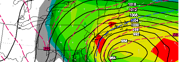
European forecast model, showing a very strong low pressure system off the coast on Friday evening. In addition, the model is forecast significant snowfall for a large portion of the area through Saturday.

European forecast model, showing a very strong low pressure system off the coast on Friday evening. In addition, the model is forecast significant snowfall for a large portion of the area through Saturday.

In what surely looks to be a dramatic break in a dry, quiet weather pattern…forecast models are honing in on the potential for a significant Nor’easter beginning late this week on Friday and continuing into this weekend. The complicated weather pattern surrounding the system has wreaked havoc on forecast models, and has left forecasters struggling to put together the pieces of the puzzle which could ultimately end in either a nor’easter (and potential blizzard in New England), or a more tame system with light rain/snow mix. Below, we attempt to detail the threat and break down the potential scenarios — while continuing to analyze the new data this afternoon.

Why is the storm developing, what’s going down? Two pieces of mid-atmospheric energy are poised to “phase” over the  Mid-Atlantic states on Thursday into Friday. The moisture-laden piece of energy from the southern jet stream is heading northward from Southeast states, while the energy from the Northern jet stream will dive southeast through the Ohio Valley. The exact timing and interaction between the two features will have dramatic impacts on the exact track and intensity of the storm system. A quicker, stronger phase will result in a much more impactful storm with the potential for widespread significant snow, wind and coastal flooding.

What are the potential scenarios we’re dealing with? There are several, and the forecast models are still struggling with the storm system. As mentioned above, a stronger and cleaner phase between the two disturbances would result in a faster deepening storm system off the coast. This becomes important, especially for our area with the cold air waning by the time the storm begins to form. The rapidly strengthening storm off the coast develops a cold conveyor belt, and draws in a significant amount of cold air in addition to dynamically cooling the atmosphere with heavy precipitation. Should this scenario unfold, widespread significant snowfall would be likely..and the intensity and track of the storm would also bring the potential for high winds and coastal flooding.

Should the two disturbances phase later, or less “cleanly”, the storm would likely not deepen rapidly until it was a bit farther to our northeast. As a result, impacts would be slightly lessened, but the potential would still exist for a mixed precipitation event ending with possibly significant snowfall. Finally, an outside chance still exists that the storm will escape to the northeast with minimal impacts — but the chances of that occurring are becoming dramatically less over time.

When will we know more details? We’re awaiting further data this afternoon and evening. After that time, we will likely have a much better idea as to how the storm will shake down later this week and weekend. At that point, later tonight the forecast models should be able to sample the pieces of energy very well and the eventual solutions should be more accurate. We are expecting to have a timeline/event detail post up later this evening, with snowfall/impact amounts forecast by  Thursday morning. Stay tuned for details especially on our Facebook and Twitter accounts.

PM Update: Light snow a possibility through the night

NAM model forecasting very light snowfall accumulations through Wednesday morning. Grey shaded areas are less than 1" of snow, while the light blue areas indicate 1" or more.

NAM model forecasting very light snowfall accumulations through Wednesday morning. Grey shaded areas are less than 1″ of snow, while the light blue areas indicate 1″ or more.

A cooler, wintry pattern which has settled into the area will continue through this evening. Despite a general lack of heavier precipitation events (other than the rain which broke the brief warmer pattern last week), various “clippers” have brought light snow to the area on more than one occasion. Totals have been low, generally below an inch aside from isolated locales. Much of the same is expected this evening as a very weak system passes near the area. Light snow will be a possibility, on and off, through the evening and overnight hours. Cold ground and surface temperatures will allow for the snow to accumulate on all surfaces, so keep an eye out for slick and slippery roads if you’re traveling at all overnight.

In addition, patches of ice have become common on many area roads, especially near corners. The snow accumulations are expected to be very minor through the overnight, so no travel delays are expected in the early morning rush hour. The snow will likely have tapered off by that time as well. Attention will then turn to the potential for a late week Noreaster, which we will detail in a technical post forthcoming this evening. Stay tuned for more information, but for now check out the short term forecast below!

Tonight: Mostly cloudy with periods of light snow. Low temperatures falling into the 20’s. Northeast winds between 5 and 10 miles per hour. Light snowfall accumulations of less than an inch are possible.

Wednesday: Mostly sunny with high temperatures reaching into the upper 30’s to low 40’s. West winds around 10 miles per hour throughout the day.

Wednesday Night: Mostly clear and cold, with low temperatures falling into the teens and 20’s (warmer near the coast). West-northwest winds between 10 and 15 miles per hour.

Dynamic storm system will highlight mid-week weather

NAM model showing temperatures rising into the 50's throughout the area Wednesday afternoon, and even 60's in parts of New Jersey.

NAM model showing temperatures rising into the 50’s throughout the area Wednesday afternoon, and even 60’s in parts of New Jersey away from the shores.

A strong storm system over the Central United States will shift northeastward beginning Tuesday and continuing into Wednesday. As it does so, a changing airmass will bring a roller-coaster of weather to a climax in our area. The bone-chilling cold of the past week will become a memory as winds turn southerly on Tuesday evening and temperatures warm up … quite dramatically, in fact. Highs over much of the area away from the coast should reach into the middle 50’s if not higher on Wednesday ahead of an approaching cold front.

That cold front will become a story as well, with the potential for a period of very heavy rain, potentially a rumble of thunder, and strong gusty winds. With the front poised to move through the area late Wednesday evening into the overnight hours of early Thursday, the period of heaviest rain looks to come after rush hour on Wednesday. But showers and clouds should be around for much of the day prior to that, despite the warm temperatures. The Storm Prediction Center suggests the potential for thunder, and an isolated threat of strong winds over Southwestern New Jersey. The greater severe weather threat will remain well to our south and west.

Gusty winds and heavy rain should taper slowly from west to east by early Thursday, with strong westerly winds building on Thursday behind the front. Another cool down will then grip the area by the end of the week, with colder temperatures and highs only into the 40’s..and the strong westerly winds continuing into Friday.