-2")
Weekend Forecast: Cold and wet start, decent finish

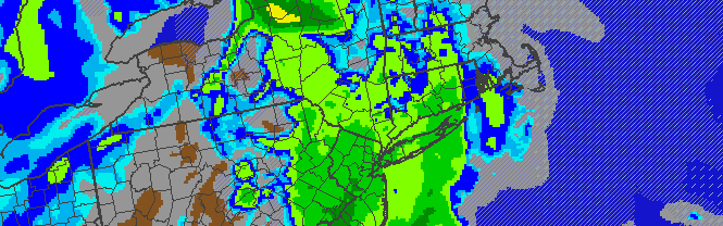
RGEM model forecasting a period of steady rain throughout the area on Saturday, despite a coastal storm offshore to our south and east. The rain could continue on and off through Saturday Night.
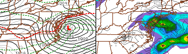
A relatively calm and pleasant (albeit cool) end to the work week will take an ugly turn as we approach the first half of the weekend, owing to a developing storm system which will track to the south and east of the area this weekend. The airmass in place is warmer than average for one surrounding a winter storm this time of year, and we’re expecting minimal winter impacts from the system. All in all, precipitation totals as a whole will end up being a nuisance with forecasting models backing off on the potential for heavy precipitation as we approach the event. Still, periods of light snow/sleet will quickly transition to periods of cold rain/showers through Saturday throughout the area. The potential exists for some freezing rain and sleet inland over Northwest NJ, Southeast NY and Connecticut, but we aren’t expecting accumulations or significant travel difficulties. The precipitation could linger through Saturday Night, but clearing is expected by Sunday. Northwest winds will return and cooler air will stay in place, with the sun returning and resulting in a decent day to close out the weekend with temperatures in the upper 30’s to low 40’s.
Through Tonight (Friday Night): Cloudy, with developing areas of light precipitation. Brief periods of sleet/freezing rain inland, transitioning to light rain everywhere. Low temperatures in the middle 30’s. Southeast winds near 10 miles per hour, so it will still feel plenty cold and raw despite the liquid precipitation. Bundle up and bring a hoodie or umbrella!
Saturday: Raw, cold, and wet start to the day with overcast skies and scattered showers. Temperatures climbing to near 40 degrees, and periods of more steady rain possible in the late morning. East winds around 10 to 15 miles per hour. Bring a rain coat and an umbrella, especially over eastern locations like the NJ Shore and Long Island.
Saturday Night: A continuing chance of showers throughout the area, with low temperatures falling into the mid 30’s. Raw, cool, and wet conditions continuing. If you’re headed out, definitely bring a rain coat, hoodie, and/or umbrella. It won’t be a pleasant night.
Sunday: Clearing, slowly and finally, with the sun making an appearance by afternoon. High temperatures reaching in the upper 30’s to near 40. Northwest winds keeping things breezy and cool, around 10 miles per hour.
Stay tuned to our Facebook and Twitter accounts for up to the minute updates on the area’s weather!