-2")
Mid January thaw a transient interruption in the pattern
The pattern over recent weeks has proven to be an interesting one across the majority of the United States, as the record cold temperatures and plentiful snow has visited folks from the Mid-west, Great Lakes, and the Northeast. Our significant snowstorm last week was due in large part to the negative EPO / positive PNA regime in concert with a well-timed Greenland block, allowing short wave amplification to occur on the mid atlantic coast. Since that time, the Greenland block has dissipated, and the western ridge will collapse in a few days, not before a near record / record cold airmass arrives Monday night.
(Log in to view this post, or purchase it for $.99 !)
[s2Member-PayPal-Button sp=”1″ ids=”4153″ exp=”72″ desc=”View this Premium Long Range Post for only $.99!” ps=”paypal” lc=”” cc=”USD” dg=”0″ ns=”1″ custom=”www.nymetroweather.com” ra=”0.99″ image=”default” output=”button” /]
Although the upcoming arctic blast will be very impressive and potentially record breaking, its duration will be short due to the lack of high latitude blocking right now. The pattern is in the process of “reloading” over the coming week to 10 days, meaning a temperature moderation to normal or above normal values is liable to occur for us from the end of this week through mid January.
The EPO block / ridge that has been a staple to our winter thus far will break down:
Initial 500mb pattern
Forecasted 500mb pattern next weekend
Notice the massive reversal in height anomalies over the crucial Alaska/North Pacific region. The higher than normal heights in the NPAC/AK region since November have provided a pattern of frequent cold shots and snow/ice opportunities, even with the unfavorable +AO/+NAO pattern.
We have seen some changes to the NAO/AO domains, however, due in part to the burst of positive AAM values since late December, which tend to promote a more perturbed tropospheric arctic vortex:
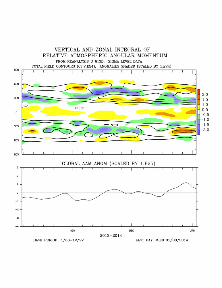
Since late December, the AO has been running closer to neutral or slightly negative, a significant decrease from the strongly positive values of Nov-Dec.
The question becomes: where do we go from here? Is the EPO breakdown a permanent change for the rest of this winter? Will the AO remain negative like it’s been since the start of 2014?
One pattern indicator which undoubtedly has led to the maintenance of the -EPO NPAC ridge and ensured its redevelopment is the strong +SSTA signal in the north Pacific. During the winter, very warm (anomalous) water in the northern latitudes tends to promote / enhance ridges, while colder water tends to feedback and allow troughs to dominate.
The present SSTA view illustrates the warm water relative to normal south of Alaska, and this argues for the redevelopment of the negative EPO regime down the road.
We have some interesting changes occurring in the stratosphere which could have impacts on the AO regime eventually as well.
Wave-1 stratospheric activity is progged to occur, meaning, there will be one large “ridge” and one “trough” feature up in the stratosphere. Wave 2 activity indicates a splitting of the polar vortex and several ridges/troughs forming in the stratosphere as a result. Both waves can eventually promote sudden stratospheric warming events, but what we’re currently progged to see will probably not yield a major warming of the stratosphere.
With that being said, the warming of the stratosphere will press against the stratospheric polar vortex causing it to elongate in a north to south fashion from Eurasia, across the north pole, and southward into the eastern United States.
Since the polar vortex is liable to remain around Greenland for the next few weeks, I don’t anticipate any major west based negative NAO blocking initiating. However the eastward expansion of stratospheric warming from the Pacific side to the north pole indicates to me that high heights could develop in the EPO and AO domains, leading to increased negative values a couple weeks down the road.
Note how the stratospheric PV at 50mb gradually moves from Asia into Canada and elongates N-S by 240hrs / Day 10:
This should, in time, promote a pattern which favors the resurgence of the poleward negative EPO, potentially coupled with help from a positive version of the PNA. The AO probably won’t see any severe negative episode for the next few weeks given the lack of a strong stratospheric warming, but global indicators in total seem to suggest a maintenance of slightly negative AO values for most of January.
The GFS ensembles show the regime we’ve had in place essentially re-emerging for the latter / late part of January. This would once again initiate cross polar flow and fill Canada with arctic air.
Thus, late January could become active again with colder than normal temperatures and snow/ice threats in the Northeast. Remains to be seen what February holds, but the pattern progression would argue for at least early February potentially featuring a cooler than normal regime in our area. The declining QBO is another factor which could eventually produce a strong stratospheric warming event and send the AO tanking, but its occurrence and effects on the pattern would be at least several weeks away from the present moment.
In sum:
-Bitterly cold, transient airmass mid week, near record to record temperatures possible
-Mid January thaw will occur late week to early/mid following week due to a +EPO surge
-Watch for potential light snow accumulation in advance of this thaw later in the week (9th-10th)
-Pattern of negative EPO, positive PNA, and negative AO likely to reload for the latter/late part of January
-Normal to Warmer than normal temps for about a 3-7 day period, followed by a return to colder than normal the final third of January, with increased storm opportunities
-The NAO remains neutral, stratospheric PV elongated but located near Greenland, no west based NAO block for the next few weeks
-February has the potential to carry over the pattern which develops in latter/late January, but stay tuned on that
Leave a Reply
Want to join the discussion?Feel free to contribute!