-2")

Slow but persistent warmup the next several days
As a warm front struggles to move north of the area today, temperatures have struggled as well — staying generally stuck in the mid 50’s for the majority of the day through the early afternoon. Although some warmer temperatures are anticipated by later this afternoon, the general theme will continue to feature east/northeasterly winds off the ocean waters and cooler than normal temperatures with clouds. A warm front has established itself to our south and west, and while that is providing much of the Mid-Atlantic with warmth, it is leaving us in a damp, marine airmass.
This front will struggle northward over the next few days, but the good news is that forecast models agree it will eventually make it. Friday looks to feature conditions more similar to Thursday than the past several days of this week — although there won’t be as many clouds, temperatures won’t reach much past the 60’s. This will be especially true near the coast, as east/northeasterly winds again bring in cooler marine air.
But the tides begin to turn on Saturday and Sunday as the warm front washes out a bit and pushes northward. Mid level ridging will build over the area and the surface warm front will push into New England. Temperatures, as a result, will rebound into the 60’s and 70’s by Sunday. With the trend toward more sunshine, temperatures on Sunday could very well surge well into the 70’s throughout a vast majority of the forecast area.
But the warming trend won’t be done — if forecast models have the right idea. The building mid level ridging, in response to a developing system in Central United States, will continue — and mid level temperatures will increase steadily once again. Forecast models are indicating the potential for high temperatures to exceed 80 degrees on both Monday and Tuesday of next week, as a cold front lingers well off to our west.
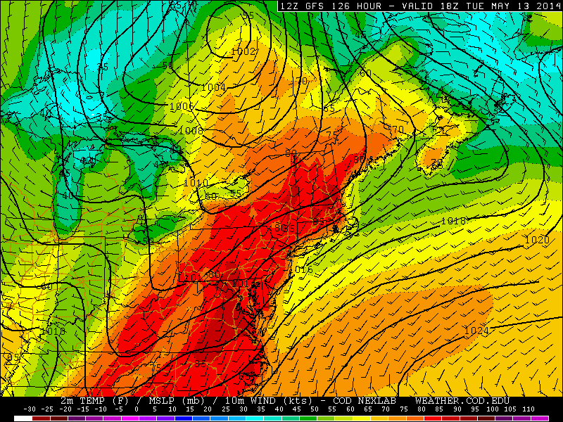
GFS model showing the potential for temperatures over 80 degrees in much of the area early next week.
The front will eventually push toward the area during the middle part of next week — and we already have seen hints of potential strong thunderstorms with its passage — but not before two days (or potentially more) of late spring/summer like weather. Exact high temperatures are difficult to pin down at this point, but the general idea is that we’re looking at the warmest days of the year to date by early next week.
For now, though, we have to endure another day of damp and cool conditions.
Leave a Reply
Want to join the discussion?Feel free to contribute!