Wonderful weekend, muggy with showers and thunderstorms early next week

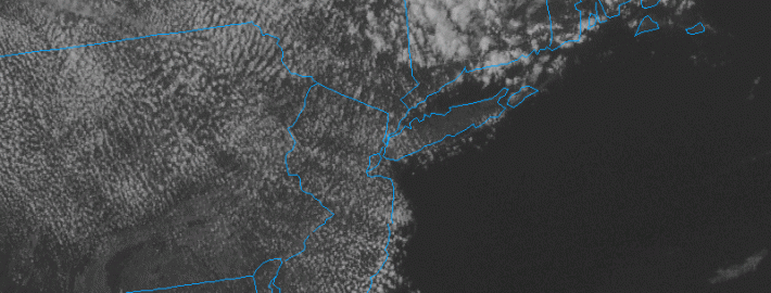
The recent trend of an unsettled work-week, but great weekend will continue, as an area of high pressure has settled into the region, and the previous frontal boundary has finally cleared. This leads to northwest winds, which are much drier in nature, thus the lack of precipitation. However, the trough that caused yesterday’s rainfall is still not too far to our northeast. This leads to cold temperatures in the middle and upper parts of the atmosphere. Once the sun heats the ground, the warm ground combined with the colder temperatures above lead to an unstable atmosphere, causing lift for cumulus clouds. This is why the sun will be peaking in and out of clouds for the rest of this afternoon. The cumulus clouds are well-evidenced by the current satellite. The stronger ones with potential showers are staying to our northeast.

Regardless, the dry atmosphere and high pressures will preclude any precipitation from forming. As high pressure continues to build in and the air gets drier, the cumulus clouds will taper off during the evening. The leftover diminishing clouds combined with temperatures in the mid 70s at the shore should lead to a great evening to view the sunset. Be careful of rip currents, however.

Tonight and Saturday: The decreasing clouds combined with a dry atmosphere will lead to ideal radiational cooling conditions. Some of you may even want a light jacket or sweatshirt tonight, as low temperatures may fall into the low to mid 50s for much of the area, though slightly warmer in the city itself. For tomorrow, the ridge will build in more strongly, leading to fewer clouds and warmer temperatures than we had today. Temperatures should rise into the mid 80s with low humidity and plenty of sunshine, with light winds. At the shore, temperatures will initially climb around 80, but the light winds and warm temperatures will not be able to stop a sea breeze, so winds may get gusty at times, but otherwise a beautiful beach day. Potentially more importantly, the weather will be great as California Chrome goes for his Triple Crown!

Today's 12z NAM at 500mb valid for tomorrow evening shows a large ridge building into the region. This will lead to a beautiful Saturday and Sunday. Image produced via GEMPAK computer program.

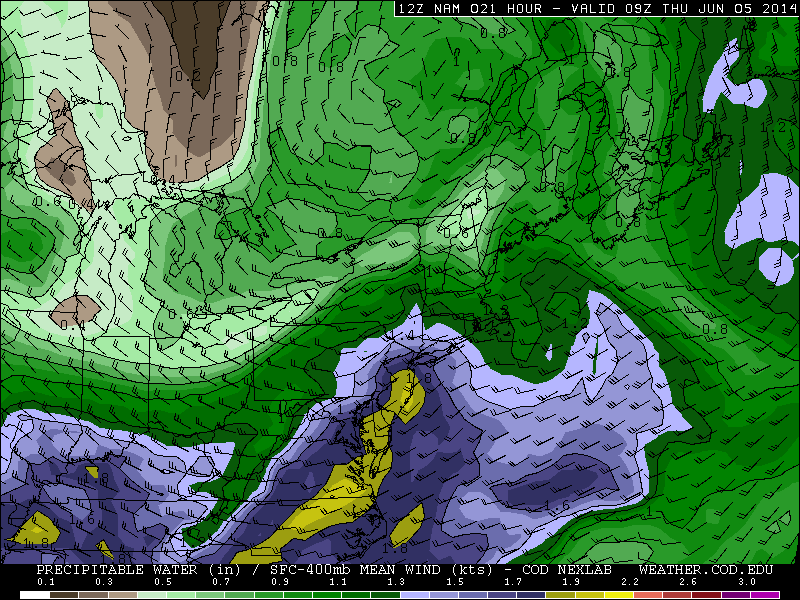
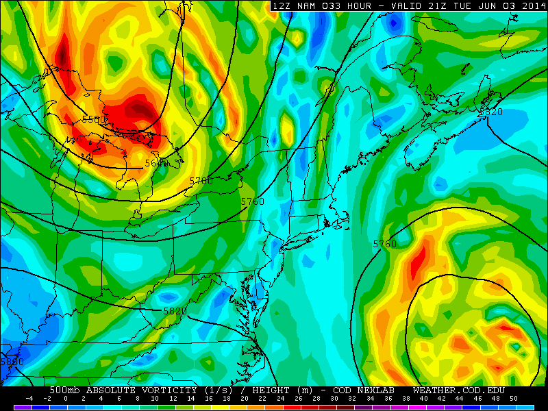
Today’s 12z NAM at 500mb valid for tomorrow evening shows a large ridge building into the region. This will lead to a beautiful Saturday and Sunday. Image produced via GEMPAK computer program.

Read more

Heavy rain and embedded thunderstorms tonight

We are currently watching a complex of showers and thunderstorms in the Midwest and Ohio Valley as it swings eastward, along a stationary frontal boundary. Additionally, a mid-level trough will be working its way into the region from the north, which will allow the storm system to strengthen, as they interact with each other. The strengthening storm system will provide plenty of lifting in the atmosphere, as well as greatly increase the strength of a southerly low-level jet, which will help to pump plenty of moisture into the region. The combination of plenty of moisture in our atmosphere and the lift will lead to the threat for heavy rain and embedded thunderstorms. The primary threat is flash flooding, as some areas may pick up 1-2″ of rain in a short period of time.

place-holder

Today’s NAM model valid for 5:00am tomorrow morning shows very high precipitable water values, which is an indicator of a very moist atmosphere profile. This supports the threat for heavy rain. (weather.cod.edu)

However, the threat for severe thunderstorms with severe winds should only be confined to the southern third of New Jersey, and that threat will be isolated. This is because the frontal boundary that the storm will be tracking on should remain in Central New Jersey. North and northeast of the warm front is where more broad lifting is expected, thus the threat for heavy rain over the entire New York Metro region.

But south of the warm front is where the lifting for precipitation is not as widespread, but the atmosphere overall is more unstable — thus the threat for isolated severe weather. This means that southern NJ may not see widespread rain, but could have a brief localized heavy downpour, with flash flooding, and a strong wind gust. The instability overall, however, is only marginally strong for severe weather — thus the severe threat being marginal and isolated. Plus there is also the fact that the instability may not be strong enough for the complex of storms to entirely maintain itself as it crosses the Appalachian Mountains.

Read more

Showers and thunderstorms expected this evening

Although a lot of the area has been able to salvage sunny skies for most of the day, clouds are on the increase and thunderstorms are forming in W NJ. The very warm and muggy airmass in association with a trough moving into the Great Lakes is the main trigger for these storms. The trough being quite far away also serves to keep wind shear quite weak. What this does is it prevents thunderstorms from becoming severe — but it also means that the storms move slowly. This, combined with the incredibly moist atmosphere leads to the potential for heavy downpours for a decently long period of time — thus the concerns for flash flooding. The strongest storms could have 40mph wind gusts and small hail — though that risk is more isolated.

As far as timing, the storms should move into Central New Jersey between 4:30 and 5:00pm, the NYC area between 5:00pm and 5:30pm, SW CT and Nassau County between 5:30pm and 6:00pm, and Suffolk County sometime after 6:00pm. Not everyone will get heavy downpours, but most of the area should see rain, with the potential for 1″ — with locally higher amounts. Definitely keep an eye on the latest radar and have the umbrella handy this evening.

Although the heaviest rain will probably fall within an hour of the storm’s arrival, showers and an isolated thunderstorm still cannot be ruled out for the rest of the overnight, and patchy fog may develop as well. Temperatures will remain in the 60s tonight with muggy conditions.

Wednesday: The showers and storms will clear the area by Wednesday morning, and the day should actually turn out to be decent, as a weak area of ridging will move in between the departing storm system, and another storm system coming for Thursday morning. It will be a bit cooler and drier than today, and skies should remain partly sunny, with temperatures in the upper 70s.

Read more

Showers and thunderstorms possible Tuesday through Thursday

Another gorgeous afternoon is on tap for today, as a ridge of high pressure remains in place. Temperatures will generally be in the upper 70s and lower 80s, though a developing sea breeze will lead to gusty winds and cooler temperatures along the shore.

Tuesday: Changes are in store for the rest of the week, however. A blocking pattern remains in-place to our northeast, which will cause a strong ocean low pressure system to retrograde to the west, towards our coast. This will weaken the ridge of high pressure, and allow a trough of low pressure to move through the Great Lakes. When a trough of low pressure interacts with a warm airmass and weakens a ridge, it is often a good recipe for shower and thunderstorm development.

place-holder

Today’s NAM model at 500mb (middle of the atmosphere) valid for tomorrow afternoon shows a large ocean system retrograding towards our coast, weakening the ridge of high pressure. At the same time, a trough will be moving into the Great Lakes. (weather.cod.edu)

One fortunate aspect is that the blocking pattern will make the trough slow to move. This means that we may still be able to salvage the entire morning and some of the afternoon tomorrow with sunshine, though clouds will be on the increase throughout the afternoon. Temperatures should rise into the upper 70s and lower 80s, with somewhat humid conditions. The threat for rain will start during the late afternoon and early evening from west to east.

Read more