Seasons first heatwave, tropical threat this week

If you weren’t already convinced that summer had arrived, you will be by the end of this upcoming week. A building ridge is expected to set the stage for the seasons first potential heatwave (with temperatures of 90+ for three days or more) during the early to middle part of the week. Additionally, a tropical system may skirt the east coast by the latter half of the week into the holiday weekend. Don’t panic about your holiday plans just yet — models are still all over the place with the exact track of the system — but many of them are bringing it precariously close to the coast at this juncture.

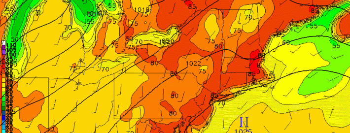
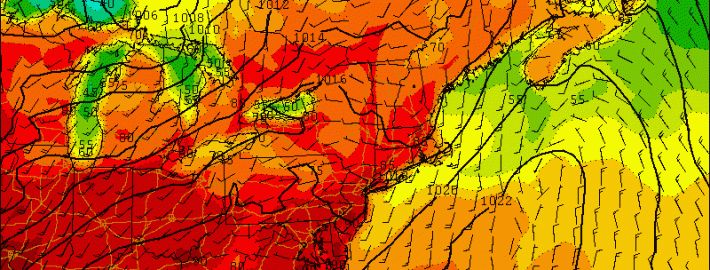
Our hazardous weather begins, though, with the aforementioned heat wave during the early to mid part of the week. By Tuesday, a building ridge and rising mid level temperatures will help bring surface temperatures well into the 80’s — and likely 90’s — in much of the area. Southerly winds could keep things a bit cooler near the shore, but will pump in the hot air elsewhere. Rising dew points and humidity won’t help. Without a shadow of a doubt, it will feel like mid summer during this week.

NAM model forecasting high temperatures in the 90's on Wednesday.

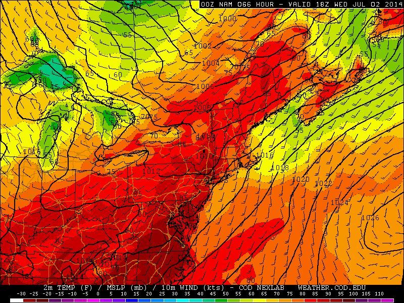
NAM model forecasting high temperatures in the 90’s on Wednesday.

Read more

Another beautiful weekend, slow warmth but no big heat next week

Another delightful weekend is on the way, as a ridge of high pressure has settled in behind a cold front. The ridging extends throughout much of the atmosphere, which is preventing clouds from forming — thus the crystal clear blue sky day we have had this afternoon.

place-holder

Today’s NAM valid for 5:00pm this afternoon shows an ideal combination of weather features throughout the entire atmosphere for sunny and tranquil conditions.

The above is a 4-panel chart from the NAM model valid for 5:00pm this afternoon. On the top left, we can see a well-defined area of surface high pressure — on the top right, we can see a nice ridge in our 850mb heights, as well as 850mb temperatures between 12 and 15C, which under sunny skies, yield high temperatures around 80 degrees. We also see that we are on the downstream side of the ridging at 500mb and 300mb, which further yields downward vertical motion associated with higher surface pressures — thus a lack of clouds. This general weather pattern will persist through the entire weekend, leading to sunny skies, low humidity, and temperatures in the low-to-mid 80s.

Read more

Heat builds, severe thunderstorm risk increases

As a mid level ridge builds throughout the eastern half of the nation today, temperatures in the mid and low levels of the atmosphere will increase. South of a warm front, which is organizing and becoming more well defined to our north, west-southwesterly winds will begin to usher in the warmer airmass. Mid level temperatures (at 850mb) will warm over 17 C, and with sunshine expected during the afternoon hours on Tuesday, temperatures will warm into the upper 80’s to lower 90’s. When coupled with increasing humidity, it will feel hot and quite muggy.

Back to our west-northwest, a mid level disturbance will be riding along the northern periphery of the building ridge axis. As it does so, it will help to trigger the development of thunderstorms — some of which could be strong to severe. These storms will initially form well to our north and west, but are expected to slide east-southeastward through the Northeast States as the disturbance shifts accordingly. Subsequently, the Storm Prediction Center has placed much of the area in a Slight Risk for severe thunderstorms.

Read more

Heat and humidity on the rise, severe thunderstorms possible Wednesday

As another beautiful weekend comes to a close, the weather will begin to change during the upcoming work-week. The airmass as a whole will become much warmer and more humid, which will lead to a true summer-like feel on Tuesday and Wednesday. Today will be a transition day.

One of the great indicators of the type of atmosphere we have is the amount of precipitable water in it. Precipitable water essentially tells us how much water would result at the surface if the entire atmosphere were to be squeezed out — like a wet towel. Thus, it is a good indicator of how much moisture is in the entire atmopshere, and not just at the surface. Large-scale changes in precipitable water is often a good indicator that the airmass is changing.

Over the past couple of weeks, we have been developing some of our own computer model forecast images. The main ones we will be using in this article overlay precipitable water, CAPE (Convective Available Potential Energy), CIN (Convective Inhibition), and 1000mb-500mb wind shear (essentially the wind shear [change in wind speed and direction] from the surface up to around half way up the atmosphere).

Today looks to be a transition day.

Notice the dry colors for precipitable water on Monday afternoon, still indicating a dry airmass. Image was produced by Doug Simonian using GEMPAK from the Rutgers synoptic server.

Notice the dry colors for precipitable water on Monday afternoon, still indicating a dry airmass. This image and all future images in this article were produced by Doug Simonian using GEMPAK from the Rutgers synoptic server.

The forecast for this afternoon shows precipitable water values still well under an inch — indicating a dry atmosphere. Thus, today for the most part should feel similar to how today felt, but perhaps a touch more humid. Skies will be sunny, but high clouds will be on the increase, and highs will be in the low 80s, with little wind.

Notice how the much more moist values are just off to our west.

Read more