-2")
Heat builds, severe thunderstorm risk increases
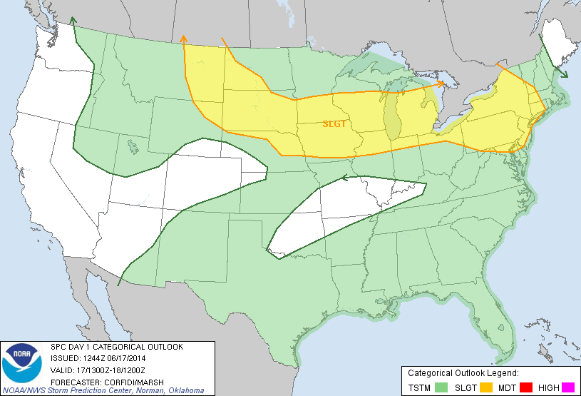
As a mid level ridge builds throughout the eastern half of the nation today, temperatures in the mid and low levels of the atmosphere will increase. South of a warm front, which is organizing and becoming more well defined to our north, west-southwesterly winds will begin to usher in the warmer airmass. Mid level temperatures (at 850mb) will warm over 17 C, and with sunshine expected during the afternoon hours on Tuesday, temperatures will warm into the upper 80’s to lower 90’s. When coupled with increasing humidity, it will feel hot and quite muggy.
Back to our west-northwest, a mid level disturbance will be riding along the northern periphery of the building ridge axis. As it does so, it will help to trigger the development of thunderstorms — some of which could be strong to severe. These storms will initially form well to our north and west, but are expected to slide east-southeastward through the Northeast States as the disturbance shifts accordingly. Subsequently, the Storm Prediction Center has placed much of the area in a Slight Risk for severe thunderstorms.
The main question in regard to the potency of the severe thunderstorm threat is the degree of mid level wind support for organized thunderstorms. Initially, the best support for storm organization will be well to our west. This is expected to shift eastward with time, but may lag behind the developing storms this evening. As such, the thunderstorms may not be organized enough to produce a widespread severe wind threat.

Moderate instability could fuel thunderstorms this evening.
Still, the potential for strong to severe thunderstorms is sufficient to trigger a Slight Risk and the storms which do eventually make it into our area will have the potential to produce frequent lightning, very heavy rain and strong winds. Additional storms are expected on Wednesday, and the Storm Prediction Center has placed our area in a Slight Risk for severe thunderstorms then as well.
The heat will continue on Wednesday, also, as the mid level ridge axis builds further toward our area while the gradient tightens a bit to our north. So hot air, rising humidity and an increasing likelihood of thunderstorms is expected once again.
Stay tuned for further details including any watches, warnings or advisories from the National Weather Service as well as additional outlooks from the Storm Prediction Center.
certainly like your web site but you need to take a look at the spelling on quite a few of your posts. A number of them are rife with spelling issues and I to find it very troublesome to tell the truth on the other hand I will certainly come back again.
Only wanna input that you have a very decent site, I enjoy the style it actually stands out.
It’s appropriate time to make some plans for the future and it’s time to be happy. I have read this post and if I could I want to suggest you some interesting things or suggestions. Perhaps you could write next articles referring to this article. I want to read more things about it!
Oh my goodness! an incredible article dude. Thanks Nevertheless I’m experiencing problem with ur rss . Don’t know why Unable to subscribe to it. Is there anyone getting similar rss drawback? Anybody who is aware of kindly respond. Thnkx
I simply wanted to say thanks again. I’m not certain what I might have implemented without the tips documented by you relating to such theme. It previously was a frightening difficulty for me, nevertheless taking a look at the very specialized avenue you treated that forced me to jump for happiness. Extremely grateful for your work and as well , pray you recognize what an amazing job that you are accomplishing educating many others by way of your blog. Most probably you’ve never encountered all of us.
I’m commenting to make you understand of the superb experience my child gained going through your webblog. She came to find a lot of pieces, including what it’s like to possess an ideal helping character to make certain people effortlessly learn about several very confusing subject matter. You really surpassed her expected results. Many thanks for coming up with the effective, trusted, educational and also unique tips on your topic to Gloria.
F*ckin’ tremendous things here. I’m very satisfied to peer your article. Thanks so much and i am taking a look ahead to touch you. Will you kindly drop me a mail?
Thank you so much for providing individuals with an exceptionally marvellous chance to read in detail from this site. It is often very useful and as well , packed with fun for me and my office acquaintances to visit your web site more than 3 times per week to see the fresh secrets you have. Not to mention, I’m certainly pleased with the striking tricks you give. Selected 3 facts in this posting are unequivocally the very best we have all ever had.
Great line up. We will be linking to this great article on our site. Keep up the good writing.
Wohh exactly what I was searching for, thanks for posting.
Wonderful web site. Plenty of helpful information here. I’m sending it to a few buddies ans also sharing in delicious. And certainly, thank you for your effort!
Really good visual appeal on this website , I’d value it 10 10.
Thank you for the sensible critique. Me & my neighbor were just preparing to do some research on this. We got a grab a book from our area library but I think I learned more clear from this post. I am very glad to see such magnificent info being shared freely out there.
I conceive this web site contains very fantastic written subject material content.
Hello would you mind stating which blog platform you’re working with? I’m going to start my own blog in the near future but I’m having a difficult time choosing between BlogEngine/Wordpress/B2evolution and Drupal. The reason I ask is because your layout seems different then most blogs and I’m looking for something completely unique. P.S Sorry for getting off-topic but I had to ask!
Great post. I am facing a couple of these problems.
Your place is valueble for me. Thanks!…
I’ve recently started a website, the information you provide on this website has helped me greatly. Thank you for all of your time & work. “Cultivation to the mind is as necessary as food to the body.” by Marcus Tullius Cicero.
I have not checked in here for a while since I thought it was getting boring, but the last few posts are great quality so I guess I will add you back to my daily bloglist. You deserve it my friend 🙂
Hello, you used to write great, but the last few posts have been kinda boringK I miss your tremendous writings. Past several posts are just a little bit out of track! come on!
I’d need to verify with you here. Which is not something I normally do! I get pleasure from studying a post that will make folks think. Also, thanks for permitting me to comment!
I really appreciate this post. I have been looking everywhere for this! Thank goodness I found it on Bing. You have made my day! Thanks again
I have recently started a site, the information you offer on this site has helped me greatly. Thanks for all of your time & work.
I am glad for commenting to let you be aware of of the exceptional discovery my wife’s daughter encountered viewing your web page. She came to understand several pieces, which included what it is like to have an amazing helping mood to get certain people without hassle master a variety of tortuous things. You really did more than visitors’ expectations. Many thanks for showing these informative, trusted, educational not to mention unique guidance on the topic to Kate.
Good write-up, I’m regular visitor of one’s website, maintain up the nice operate, and It’s going to be a regular visitor for a long time.
of course like your web-site however you have to test the spelling on quite a few of your posts. Many of them are rife with spelling issues and I find it very troublesome to tell the truth nevertheless I will certainly come back again.
Wonderful blog! I found it while browsing on Yahoo News. Do you have any suggestions on how to get listed in Yahoo News? I’ve been trying for a while but I never seem to get there! Thanks
I genuinely treasure your work, Great post.
I really appreciate this post. I’ve been looking everywhere for this! Thank goodness I found it on Bing. You have made my day! Thanks again
I’ve recently started a blog, the information you provide on this web site has helped me greatly. Thanks for all of your time & work.
Utterly written content material, thank you for information. “The bravest thing you can do when you are not brave is to profess courage and act accordingly.” by Corra Harris.
As I website possessor I believe the content material here is rattling excellent , appreciate it for your hard work. You should keep it up forever! Good Luck.
I like this website so much, saved to fav. “American soldiers must be turned into lambs and eating them is tolerated.” by Muammar Qaddafi.
It’s in point of fact a nice and useful piece of info. I’m satisfied that you shared this useful information with us. Please keep us up to date like this. Thank you for sharing.
Heya i am for the first time here. I found this board and I find It really useful & it helped me out much. I hope to give something back and help others like you aided me.
Hello! I just would like to give a huge thumbs up for the great info you have here on this post. I will be coming back to your blog for more soon.
I was reading through some of your articles on this website and I think this website is very informative! Keep on putting up.
I’m now not sure where you’re getting your info, however good topic. I must spend some time finding out much more or figuring out more. Thanks for magnificent info I used to be searching for this info for my mission.
I genuinely appreciate your piece of work, Great post.
Some really nice and utilitarian info on this website, also I conceive the layout holds wonderful features.
I real pleased to find this web site on bing, just what I was searching for : D as well saved to favorites.
I was wondering if you ever considered changing the structure of your website? Its very well written; I love what youve got to say. But maybe you could a little more in the way of content so people could connect with it better. Youve got an awful lot of text for only having 1 or 2 images. Maybe you could space it out better?
Hi there, just became alert to your blog through Google, and found that it’s truly informative. I am going to watch out for brussels. I will appreciate if you continue this in future. Numerous people will be benefited from your writing. Cheers!
Superb post however , I was wondering if you could write a litte more on this topic? I’d be very grateful if you could elaborate a little bit more. Cheers!
I’ve been exploring for a bit for any high quality articles or blog posts on this sort of area . Exploring in Yahoo I at last stumbled upon this website. Reading this information So i’m happy to convey that I have an incredibly good uncanny feeling I discovered exactly what I needed. I most certainly will make certain to do not forget this website and give it a glance regularly.
I got what you intend,saved to my bookmarks, very nice site.
Hello there, You have done a fantastic job. I will definitely digg it and personally recommend to my friends. I’m sure they’ll be benefited from this site.
I will immediately grab your rss feed as I can’t find your e-mail subscription link or e-newsletter service. Do you have any? Please let me know so that I could subscribe. Thanks.
I have been browsing online more than 3 hours as of late, but I never found any attention-grabbing article like yours. It’s pretty worth sufficient for me. Personally, if all web owners and bloggers made good content material as you did, the net will likely be a lot more useful than ever before.
You are my aspiration, I own few blogs and rarely run out from to brand : (.
Its superb as your other blog posts : D, regards for putting up. “A great flame follows a little spark.” by Dante Alighieri.
My husband and i felt absolutely satisfied when John could round up his analysis from the precious recommendations he acquired from your very own web page. It’s not at all simplistic to just always be giving freely tactics that many people today might have been making money from. So we see we have got the writer to thank because of that. Most of the explanations you’ve made, the straightforward site navigation, the relationships your site help instill – it’s got most wonderful, and it’s assisting our son in addition to our family know that that content is fun, which is certainly extremely essential. Thanks for all!
I dugg some of you post as I cerebrated they were very helpful very helpful
I am not sure where you’re getting your info, but good topic. I needs to spend some time learning much more or understanding more. Thanks for fantastic info I was looking for this info for my mission.
Great write-up, I’m normal visitor of one’s blog, maintain up the nice operate, and It is going to be a regular visitor for a long time.
Fantastic blog! Do you have any tips for aspiring writers? I’m planning to start my own blog soon but I’m a little lost on everything. Would you advise starting with a free platform like WordPress or go for a paid option? There are so many choices out there that I’m totally confused .. Any suggestions? Thanks a lot!
Hello, you used to write magnificent, but the last few posts have been kinda boring… I miss your super writings. Past several posts are just a bit out of track! come on!
Fantastic beat ! I wish to apprentice while you amend your site, how can i subscribe for a blog web site? The account helped me a acceptable deal. I had been tiny bit acquainted of this your broadcast offered bright clear concept
Appreciate it for this post, I am a big fan of this site would like to proceed updated.
I like this blog very much, Its a really nice post to read and obtain information.
Good day! This is kind of off topic but I need some help from an established blog. Is it tough to set up your own blog? I’m not very techincal but I can figure things out pretty quick. I’m thinking about making my own but I’m not sure where to start. Do you have any ideas or suggestions? With thanks
you have got a great weblog here! would you wish to make some invite posts on my weblog?
Everything is very open and very clear explanation of issues. was truly information. Your website is very useful. Thanks for sharing.
I like this web blog very much, Its a really nice spot to read and obtain info . “You have to lead people gently toward what they already know is right.” by Philip.
Hi there, You’ve done an excellent job. I’ll definitely digg it and personally suggest to my friends. I’m sure they’ll be benefited from this website.
Rattling clear site, appreciate it for this post.
Whats Taking place i am new to this, I stumbled upon this I’ve found It absolutely helpful and it has helped me out loads. I am hoping to give a contribution & assist different users like its helped me. Good job.
I love it when people come together and share opinions, great blog, keep it up.
I needed to write you a little note to finally say thanks a lot over again for your wonderful methods you’ve provided on this website. It was so strangely open-handed of you in giving publicly precisely what some people might have marketed for an e-book to help make some bucks for their own end, even more so given that you might well have done it if you desired. The tactics additionally acted to become good way to be sure that some people have the identical fervor like mine to know the truth very much more pertaining to this matter. I believe there are thousands of more fun situations ahead for people who read through your blog post.
Perfect work you have done, this web site is really cool with superb info .
I’m impressed, I must say. Actually hardly ever do I encounter a blog that’s both educative and entertaining, and let me tell you, you’ve hit the nail on the head. Your thought is outstanding; the problem is something that not sufficient individuals are talking intelligently about. I’m very glad that I stumbled across this in my search for something regarding this.
Great post. I am facing a couple of these problems.
Thanks for some other excellent article. Where else may anyone get that type of information in such an ideal means of writing? I have a presentation next week, and I am at the look for such information.
Wow! Thank you! I always needed to write on my website something like that. Can I include a part of your post to my site?
Hi there, just became aware of your blog through Google, and found that it’s truly informative. I am going to watch out for brussels. I’ll be grateful if you continue this in future. Lots of people will be benefited from your writing. Cheers!
Usually I do not learn post on blogs, but I would like to say that this write-up very forced me to take a look at and do it! Your writing taste has been amazed me. Thank you, very nice post.
Good day! I know this is somewhat off topic but I was wondering if you knew where I could find a captcha plugin for my comment form? I’m using the same blog platform as yours and I’m having difficulty finding one? Thanks a lot!
Having read this I thought it was very informative. I appreciate you taking the time and effort to put this article together. I once again find myself spending way to much time both reading and commenting. But so what, it was still worth it!
I’m curious to find out what blog system you have been using? I’m experiencing some minor security issues with my latest site and I’d like to find something more safeguarded. Do you have any suggestions?
This is the right blog for anyone who wants to find out about this topic. You realize so much its almost hard to argue with you (not that I actually would want…HaHa). You definitely put a new spin on a topic thats been written about for years. Great stuff, just great!
Would love to forever get updated great blog! .
I will right away grab your rss as I can not in finding your email subscription hyperlink or e-newsletter service. Do you have any? Kindly allow me realize in order that I may subscribe. Thanks.
I’ve learn several just right stuff here. Definitely value bookmarking for revisiting. I wonder how a lot effort you set to create this type of fantastic informative website.
Good post however , I was wanting to know if you could write a litte more on this subject? I’d be very thankful if you could elaborate a little bit more. Bless you!
I’m really impressed together with your writing abilities as neatly as with the format for your blog. Is that this a paid topic or did you customize it yourself? Either way keep up the nice quality writing, it is uncommon to peer a nice weblog like this one today..
Very interesting subject , appreciate it for posting.
I wanted to type a simple comment in order to say thanks to you for some of the fantastic secrets you are giving here. My time consuming internet lookup has at the end been recognized with incredibly good information to write about with my pals. I would admit that most of us visitors actually are quite lucky to exist in a magnificent network with very many wonderful professionals with useful guidelines. I feel somewhat lucky to have encountered your web site and look forward to plenty of more fun minutes reading here. Thank you once again for all the details.
You really make it appear so easy along with your presentation but I find this topic to be really one thing which I believe I’d never understand. It sort of feels too complicated and extremely extensive for me. I am having a look ahead on your subsequent post, I’ll try to get the hold of it!
clear run-down made emotional from solana to sui elementary and picked the precise usdc – [url]https://sui-bridge.hashnode.dev/how-to-bridge-usdc-to-sui-cctp-vs-native-sui-bridge-routes[/url]
Thankyou for helping out, excellent info .
Lovely site! I am loving it!! Will be back later to read some more. I am bookmarking your feeds also
Whats Going down i’m new to this, I stumbled upon this I’ve found It positively helpful and it has aided me out loads. I’m hoping to give a contribution & aid other customers like its helped me. Great job.
Outstanding post, you have pointed out some superb details , I also conceive this s a very wonderful website.
Hi, just required you to know I he added your site to my Google bookmarks due to your layout. But seriously, I believe your internet site has 1 in the freshest theme I??ve came across. It extremely helps make reading your blog significantly easier.
Hey are using WordPress for your blog platform? I’m new to the blog world but I’m trying to get started and set up my own. Do you require any coding knowledge to make your own blog? Any help would be really appreciated!
F*ckin’ remarkable things here. I am very glad to see your article. Thanks a lot and i’m looking forward to contact you. Will you kindly drop me a e-mail?
Do you have a spam issue on this website; I also am a blogger, and I was wanting to know your situation; many of us have created some nice practices and we are looking to swap strategies with other folks, be sure to shoot me an email if interested.
quick bnb to eth transfer, funds landed right away – [url]https://rhinobridge.app[/url]
Merely wanna say that this is very helpful, Thanks for taking your time to write this.
nimble-witted eth to polygon swap, funds landed righteous away – [url]https://jumperbridge.app/[/url]
wonderful submit, very informative. I ponder why the opposite specialists of this sector don’t understand this. You must proceed your writing. I’m confident, you have a great readers’ base already!
I have been exploring for a little bit for any high quality articles or blog posts in this sort of house . Exploring in Yahoo I ultimately stumbled upon this web site. Reading this info So i am happy to exhibit that I’ve a very just right uncanny feeling I came upon just what I needed. I so much for sure will make certain to don’t fail to remember this web site and provides it a look on a continuing basis.
You must take part in a contest for one of the best blogs on the web. I’ll recommend this website!
Do you have a spam problem on this blog; I also am a blogger, and I was wondering your situation; many of us have developed some nice methods and we are looking to trade methods with other folks, please shoot me an e-mail if interested.
Once I originally commented I clicked the -Notify me when new feedback are added- checkbox and now every time a remark is added I get 4 emails with the identical comment. Is there any way you may remove me from that service? Thanks!
I was just looking for this information for a while. After 6 hours of continuous Googleing, finally I got it in your website. I wonder what’s the lack of Google strategy that do not rank this kind of informative web sites in top of the list. Normally the top websites are full of garbage.
I got what you intend,saved to bookmarks, very decent website .
The very crux of your writing while sounding reasonable originally, did not really work very well with me after some time. Somewhere throughout the sentences you actually were able to make me a believer but only for a short while. I still have got a problem with your jumps in assumptions and you would do well to fill in those breaks. If you actually can accomplish that, I would definitely be impressed.
Hi there just wanted to give you a quick heads up. The text in your post seem to be running off the screen in Ie. I’m not sure if this is a formatting issue or something to do with web browser compatibility but I figured I’d post to let you know. The layout look great though! Hope you get the issue solved soon. Cheers
I adore meeting useful information , this post has got me even more info! .
I have recently started a blog, the information you provide on this site has helped me greatly. Thanks for all of your time & work.
I used to be recommended this web site by means of my cousin. I’m no longer sure whether this submit is written through him as nobody else know such designated approximately my difficulty. You’re incredible! Thanks!
Really excellent info can be found on blog. “Politics is applesauce.” by Will Rogers.
Do you have a spam issue on this website; I also am a blogger, and I was wanting to know your situation; many of us have created some nice practices and we are looking to exchange solutions with other folks, why not shoot me an email if interested.
I simply couldn’t depart your website before suggesting that I actually enjoyed the usual info an individual provide to your guests? Is gonna be again frequently in order to inspect new posts.
You should take part in a contest for one of the best blogs on the web. I will recommend this site!
Some truly nice and useful information on this internet site, too I think the layout has fantastic features.
I like the valuable info you provide on your articles. I’ll bookmark your blog and check once more here regularly. I am moderately certain I will be informed lots of new stuff right here! Best of luck for the next!
Heya i am for the first time here. I came across this board and I find It really helpful & it helped me out a lot. I am hoping to offer one thing back and help others such as you aided me.
It’s really a great and helpful piece of information. I’m satisfied that you simply shared this helpful information with us. Please keep us up to date like this. Thank you for sharing.
Good day! Do you know if they make any plugins to assist with SEO? I’m trying to get my blog to rank for some targeted keywords but I’m not seeing very good results. If you know of any please share. Appreciate it!
Simply wanna comment on few general things, The website layout is perfect, the content is real superb : D.
As I website owner I conceive the articles here is real great, thanks for your efforts.
I couldn’t resist commenting
I truly appreciate this post. I have been looking everywhere for this! Thank goodness I found it on Bing. You’ve made my day! Thanks again
Definitely, what a fantastic blog and instructive posts, I surely will bookmark your website.All the Best!
What i don’t understood is actually how you’re not actually much more well-liked than you might be right now. You’re very intelligent. You realize therefore significantly relating to this subject, made me personally consider it from a lot of varied angles. Its like men and women aren’t fascinated unless it’s one thing to accomplish with Lady gaga! Your own stuffs nice. Always maintain it up!
I was just searching for this info for some time. After six hours of continuous Googleing, finally I got it in your site. I wonder what is the lack of Google strategy that don’t rank this kind of informative websites in top of the list. Normally the top websites are full of garbage.
fantastic post.Never knew this, thankyou for letting me know.
There are actually a whole lot of particulars like that to take into consideration. That may be a great level to bring up. I supply the thoughts above as basic inspiration however clearly there are questions like the one you convey up where a very powerful thing shall be working in honest good faith. I don?t know if finest practices have emerged round issues like that, however I’m certain that your job is clearly recognized as a good game. Both boys and girls really feel the impact of only a moment’s pleasure, for the remainder of their lives.
You have remarked very interesting details! ps decent site.
I’d have to examine with you here. Which is not one thing I usually do! I take pleasure in reading a post that may make folks think. Additionally, thanks for permitting me to comment!
Hmm it seems like your website ate my first comment (it was extremely long) so I guess I’ll just sum it up what I had written and say, I’m thoroughly enjoying your blog. I as well am an aspiring blog blogger but I’m still new to the whole thing. Do you have any tips for newbie blog writers? I’d genuinely appreciate it.
I see something really special in this site.
I have learn a few excellent stuff here. Certainly worth bookmarking for revisiting. I wonder how so much attempt you put to make such a great informative website.
When I initially commented I clicked the -Notify me when new feedback are added- checkbox and now every time a remark is added I get four emails with the identical comment. Is there any method you possibly can take away me from that service? Thanks!
Whats up very nice website!! Man .. Beautiful .. Amazing .. I will bookmark your web site and take the feeds additionally…I am satisfied to find so many useful info here within the post, we’d like work out extra strategies on this regard, thanks for sharing.
I have been absent for a while, but now I remember why I used to love this site. Thanks, I will try and check back more frequently. How frequently you update your web site?
Super-Duper website! I am loving it!! Will be back later to read some more. I am taking your feeds also.
My wife and i got so delighted when Emmanuel could conclude his analysis using the ideas he got through the web pages. It is now and again perplexing to simply possibly be freely giving procedures which other folks could have been selling. And we also recognize we need the blog owner to thank for this. The specific explanations you’ve made, the simple web site navigation, the friendships you will make it possible to foster – it’s got all wonderful, and it’s leading our son and our family know that the issue is exciting, which is certainly rather essential. Thanks for all the pieces!
This is a very good tips especially to those new to blogosphere, brief and accurate information… Thanks for sharing this one. A must read article.
Having read this I thought it was very informative. I appreciate you taking the time and effort to put this article together. I once again find myself spending way to much time both reading and commenting. But so what, it was still worth it!
Hello! I know this is kinda off topic however I’d figured I’d ask. Would you be interested in exchanging links or maybe guest authoring a blog post or vice-versa? My website discusses a lot of the same topics as yours and I feel we could greatly benefit from each other. If you might be interested feel free to shoot me an email. I look forward to hearing from you! Fantastic blog by the way!
We’re a gaggle of volunteers and starting a brand new scheme in our community. Your site provided us with useful information to work on. You have performed an impressive task and our whole neighborhood will probably be thankful to you.
Great beat ! I wish to apprentice while you amend your site, how could i subscribe for a blog website? The account helped me a acceptable deal. I had been a little bit acquainted of this your broadcast provided bright clear idea
Some genuinely rattling work on behalf of the owner of this internet site, perfectly outstanding subject matter.
Thank you for the good writeup. It in fact was a amusement account it. Look advanced to more added agreeable from you! By the way, how could we communicate?
An impressive share, I just given this onto a colleague who was doing a little analysis on this. And he in fact bought me breakfast because I found it for him.. smile. So let me reword that: Thnx for the treat! But yeah Thnkx for spending the time to discuss this, I feel strongly about it and love reading more on this topic. If possible, as you become expertise, would you mind updating your blog with more details? It is highly helpful for me. Big thumb up for this blog post!
Thanks for the sensible critique. Me and my neighbor were just preparing to do some research on this. We got a grab a book from our area library but I think I learned more clear from this post. I’m very glad to see such fantastic information being shared freely out there.
Some truly nice and useful info on this internet site, as well I conceive the layout holds great features.
Undeniably believe that which you stated. Your favorite justification appeared to be on the net the simplest thing to be aware of. I say to you, I definitely get irked while people think about worries that they just don’t know about. You managed to hit the nail upon the top and defined out the whole thing without having side-effects , people can take a signal. Will probably be back to get more. Thanks
It’s really a nice and useful piece of information. I’m glad that you shared this useful info with us. Please keep us informed like this. Thanks for sharing.
Hiya very cool blog!! Guy .. Excellent .. Amazing .. I will bookmark your site and take the feeds also?KI’m happy to seek out a lot of useful information here within the publish, we need develop extra techniques on this regard, thanks for sharing. . . . . .
Some truly interesting points you have written.Assisted me a lot, just what I was searching for :D.
Today, I went to the beach front with my children. I found a sea shell and gave it to my 4 year old daughter and said “You can hear the ocean if you put this to your ear.” She placed the shell to her ear and screamed. There was a hermit crab inside and it pinched her ear. She never wants to go back! LoL I know this is entirely off topic but I had to tell someone!
Only a smiling visitant here to share the love (:, btw great pattern. “Better by far you should forget and smile than that you should remember and be sad.” by Christina Georgina Rossetti.
I’ve been absent for some time, but now I remember why I used to love this website. Thanks, I’ll try and check back more often. How frequently you update your web site?
Usually I don’t read article on blogs, however I wish to say that this write-up very pressured me to take a look at and do so! Your writing style has been surprised me. Thank you, quite nice article.
Enjoyed reading through this, very good stuff, regards.
Appreciate it for helping out, good info. “You must do the things you think you cannot do.” by Eleanor Roosevelt.
I was just searching for this information for some time. After six hours of continuous Googleing, at last I got it in your website. I wonder what is the lack of Google strategy that don’t rank this type of informative websites in top of the list. Normally the top websites are full of garbage.
Thanks for sharing excellent informations. Your web site is so cool. I am impressed by the details that you’ve on this site. It reveals how nicely you understand this subject. Bookmarked this web page, will come back for extra articles. You, my pal, ROCK! I found just the information I already searched everywhere and simply could not come across. What a great website.
I truly wanted to write a brief note to be able to express gratitude to you for these amazing tips and tricks you are placing at this website. My extensive internet investigation has at the end been recognized with awesome strategies to exchange with my pals. I ‘d mention that most of us site visitors actually are very much fortunate to be in a fine site with very many awesome people with beneficial strategies. I feel quite grateful to have used your entire site and look forward to many more fabulous moments reading here. Thank you once again for a lot of things.
I went over this internet site and I believe you have a lot of good info, saved to favorites (:.
You could definitely see your enthusiasm in the work you write. The world hopes for more passionate writers like you who are not afraid to say how they believe. Always follow your heart.
I together with my pals have already been reading the nice helpful hints located on the website then the sudden got a terrible feeling I had not thanked the blog owner for those techniques. Most of the boys came as a consequence passionate to learn all of them and already have absolutely been taking advantage of those things. Appreciate your simply being so helpful as well as for choosing these kinds of magnificent things most people are really eager to discover. Our sincere regret for not expressing appreciation to earlier.
Can I just say what a aid to search out somebody who really is aware of what theyre speaking about on the internet. You undoubtedly know the best way to convey an issue to gentle and make it important. More individuals have to learn this and understand this side of the story. I cant believe youre not more popular since you positively have the gift.
I am not very good with English but I line up this rattling easygoing to interpret.
Hey there! Do you use Twitter? I’d like to follow you if that would be ok. I’m definitely enjoying your blog and look forward to new updates.
I simply couldn’t leave your website prior to suggesting that I really enjoyed the usual info a person provide for your visitors? Is going to be again ceaselessly to check out new posts.
I’ve recently started a site, the information you offer on this web site has helped me tremendously. Thanks for all of your time & work.
Great, I should certainly pronounce, impressed with your site. I had no trouble navigating through all the tabs as well as related information ended up being truly simple to do to access. I recently found what I hoped for before you know it in the least. Quite unusual. Is likely to appreciate it for those who add forums or something, website theme . a tones way for your customer to communicate. Nice task.
Hey very nice web site!! Man .. Excellent .. Amazing .. I will bookmark your website and take the feeds also…I’m happy to find a lot of useful info here in the post, we need develop more techniques in this regard, thanks for sharing. . . . . .
Hey very nice blog!! Man .. Beautiful .. Amazing .. I will bookmark your web site and take the feeds also…I am happy to find a lot of useful information here in the post, we need develop more techniques in this regard, thanks for sharing. . . . . .
I am happy that I found this web site, precisely the right info that I was looking for! .
Very interesting details you have noted, appreciate it for putting up.
Simply wish to say your article is as surprising. The clarity for your put up is just cool and that i could think you are an expert in this subject. Well with your permission let me to clutch your feed to stay updated with coming near near post. Thank you a million and please carry on the rewarding work.
Some genuinely fantastic work on behalf of the owner of this web site, absolutely great content material.
I like the helpful information you provide in your articles. I will bookmark your weblog and check again here frequently. I’m quite sure I’ll learn plenty of new stuff right here! Best of luck for the next!
It’s actually a great and helpful piece of info. I’m glad that you shared this useful info with us. Please stay us informed like this. Thank you for sharing.
I don’t even understand how I finished up right here, however I believed this submit was once good. I do not understand who you might be but certainly you’re going to a well-known blogger if you happen to aren’t already 😉 Cheers!
This is the right blog for anyone who wants to find out about this topic. You realize so much its almost hard to argue with you (not that I actually would want…HaHa). You definitely put a new spin on a topic thats been written about for years. Great stuff, just great!
I have been checking out some of your posts and i can state clever stuff. I will definitely bookmark your blog.
Enjoyed looking at this, very good stuff, thankyou. “Golf isn’t a game, it’s a choice that one makes with one’s life.” by Charles Rosin.
Great paintings! This is the type of information that should be shared across the internet. Disgrace on the seek engines for not positioning this submit upper! Come on over and consult with my web site . Thanks =)
This website is really a stroll-by means of for the entire info you needed about this and didn’t know who to ask. Glimpse here, and also you’ll positively discover it.
I always was concerned in this subject and stock still am, thankyou for posting.
This is a topic close to my heart cheers, where are your contact details though?
I have read several good stuff here. Definitely price bookmarking for revisiting. I surprise how so much attempt you set to make this sort of excellent informative website.
Heya i am for the first time here. I found this board and I find It truly useful & it helped me out much. I hope to give something back and aid others like you aided me.
You really make it appear so easy with your presentation however I find this topic to be really something which I think I might by no means understand. It kind of feels too complex and very extensive for me. I’m looking ahead for your subsequent post, I will attempt to get the grasp of it!
I will right away grab your rss as I can not find your email subscription link or e-newsletter service. Do you have any? Kindly let me know so that I could subscribe. Thanks.
You have noted very interesting points! ps nice internet site.
F*ckin’ remarkable issues here. I’m very glad to look your post. Thank you so much and i am looking ahead to touch you. Will you kindly drop me a e-mail?
Perfectly composed content material, Really enjoyed studying.
As a Newbie, I am permanently browsing online for articles that can be of assistance to me. Thank you
Hey there! This is kind of off topic but I need some guidance from an established blog. Is it hard to set up your own blog? I’m not very techincal but I can figure things out pretty fast. I’m thinking about setting up my own but I’m not sure where to begin. Do you have any points or suggestions? Thank you
I wanted to thank you for this great read!! I definitely enjoying every little bit of it I have you bookmarked to check out new stuff you post…
Your home is valueble for me. Thanks!…
Today, while I was at work, my sister stole my apple ipad and tested to see if it can survive a forty foot drop, just so she can be a youtube sensation. My apple ipad is now broken and she has 83 views. I know this is totally off topic but I had to share it with someone!
I haven’t checked in here for a while as I thought it was getting boring, but the last few posts are great quality so I guess I’ll add you back to my everyday bloglist. You deserve it my friend 🙂
Hi, I think your site might be having browser compatibility issues. When I look at your website in Safari, it looks fine but when opening in Internet Explorer, it has some overlapping. I just wanted to give you a quick heads up! Other then that, fantastic blog!
When I initially commented I clicked the -Notify me when new feedback are added- checkbox and now each time a comment is added I get four emails with the same comment. Is there any method you possibly can take away me from that service? Thanks!
Hi there! This post couldn’t be written any better! Reading through this post reminds me of my previous room mate! He always kept talking about this. I will forward this article to him. Pretty sure he will have a good read. Thank you for sharing!
I am typically to running a blog and i really admire your content. The article has actually peaks my interest. I’m going to bookmark your web site and maintain checking for brand new information.
Does your blog have a contact page? I’m having trouble locating it but, I’d like to send you an email. I’ve got some suggestions for your blog you might be interested in hearing. Either way, great blog and I look forward to seeing it develop over time.
I do agree with all of the ideas you have presented in your post. They are very convincing and will definitely work. Still, the posts are too short for starters. Could you please extend them a bit from next time? Thanks for the post.
Electronic Business Card – The Smart Card. Create and share your professional electronic business card easily. In minutes. Choose from 100+ templates, connect with clients, and grow your business today!
great put up, very informative. I’m wondering why the opposite experts of this sector don’t notice this. You must proceed your writing. I’m sure, you’ve a huge readers’ base already!
I very happy to find this web site on bing, just what I was looking for : D as well saved to my bookmarks.
Good write-up, I’m normal visitor of one’s site, maintain up the nice operate, and It is going to be a regular visitor for a long time.
You have noted very interesting points! ps nice site.
Hello, i think that i saw you visited my web site so i came to “return the favor”.I am attempting to find things to enhance my web site!I suppose its ok to use a few of your ideas!!
hi!,I love your writing so a lot! percentage we keep up a correspondence extra about your article on AOL? I need a specialist on this area to unravel my problem. May be that’s you! Taking a look ahead to peer you.
I’d have to check with you here. Which is not something I often do! I enjoy studying a publish that may make folks think. Also, thanks for allowing me to remark!
you’re really a good webmaster. The web site loading speed is amazing. It seems that you are doing any unique trick. Moreover, The contents are masterpiece. you have done a wonderful job on this topic!
Wonderful work! This is the type of info that should be shared around the web. Shame on the search engines for not positioning this post higher! Come on over and visit my site . Thanks =)
I’m not sure why but this website is loading very slow for me. Is anyone else having this issue or is it a problem on my end? I’ll check back later and see if the problem still exists.
Would love to incessantly get updated outstanding web blog! .
Very interesting details you have remarked, thanks for putting up. “Jive Lady Just hang loose blood. She gonna handa your rebound on the med side.” by Airplane.
Hello! This is kind of off topic but I need some guidance from an established blog. Is it hard to set up your own blog? I’m not very techincal but I can figure things out pretty quick. I’m thinking about creating my own but I’m not sure where to begin. Do you have any ideas or suggestions? Cheers
Rattling nice design and wonderful subject matter, nothing else we want :D.
Pretty section of content. I just stumbled upon your website and in accession capital to assert that I acquire in fact enjoyed account your blog posts. Anyway I will be subscribing to your feeds and even I achievement you access consistently fast.
It’s actually a nice and helpful piece of info. I am glad that you just shared this helpful information with us. Please stay us up to date like this. Thanks for sharing.
Real instructive and excellent anatomical structure of content, now that’s user genial (:.
Well I truly enjoyed reading it. This post offered by you is very useful for good planning.
Aw, this was a really nice post. In concept I would like to put in writing like this moreover – taking time and precise effort to make a very good article… however what can I say… I procrastinate alot and by no means appear to get one thing done.
Howdy very nice website!! Man .. Excellent .. Superb .. I will bookmark your website and take the feeds also?KI am satisfied to seek out a lot of useful information here in the publish, we want work out extra strategies in this regard, thanks for sharing. . . . . .
Hey! I just wanted to ask if you ever have any issues with hackers? My last blog (wordpress) was hacked and I ended up losing many months of hard work due to no data backup. Do you have any methods to stop hackers?
Usually I don’t read article on blogs, but I would like to say that this write-up very forced me to try and do it! Your writing style has been surprised me. Thanks, very nice post.
Its like you learn my thoughts! You seem to know a lot about this, such as you wrote the e-book in it or something. I feel that you simply can do with a few percent to drive the message home a bit, but other than that, that is great blog. A fantastic read. I will definitely be back.
Wow that was odd. I just wrote an extremely long comment but after I clicked submit my comment didn’t show up. Grrrr… well I’m not writing all that over again. Anyway, just wanted to say excellent blog!
I am often to blogging and i really appreciate your content. The article has really peaks my interest. I am going to bookmark your site and keep checking for new information.
Way cool, some valid points! I appreciate you making this article available, the rest of the site is also high quality. Have a fun.
Hello There. I found your blog the usage of msn. This is a really smartly written article. I’ll make sure to bookmark it and return to learn more of your useful info. Thanks for the post. I’ll definitely comeback.
sharing some decent crypto links here
[url]https://seedify-page.github.io/[/url]
[url]https://silverswap-app.github.io/[/url]
[url]https://sell-nft.github.io/[/url]
[url]https://simple-swap.github.io/[/url]
[url]https://sell-crypto-online.github.io/[/url]
[url]https://scroll-swap.github.io/[/url]
[url]https://sell-nft-instantly.github.io/[/url]
[url]https://rocket-pool-staking.github.io/[/url]
[url]https://scroll-cross-chain-bridge.github.io/[/url]
[url]https://scan-aml.github.io/[/url]
[url]https://solo-staking.github.io/[/url]
[url]https://solana-staking.github.io/[/url]
[url]https://sell-wbtc.github.io/[/url]
[url]https://safe-staking.github.io/[/url]
[url]https://space-fi.github.io/[/url]
some solid crypto projects worth a look
[url]https://ren-bridge.github.io/[/url]
[url]https://polygonbridge-v1.github.io/[/url]
[url]https://quickswap-page.github.io/[/url]
[url]https://polymarket-site.github.io/[/url]
[url]https://renbridge-protocol.github.io/[/url]
[url]https://rango-exchange-page.github.io/[/url]
[url]https://retro-bridge-app.github.io/[/url]
[url]https://poocoin-app.github.io/[/url]
[url]https://pulsechain-bridge.github.io/[/url]
[url]https://rhino-bridge-site.github.io/[/url]
[url]https://polygon-bridge-app.github.io/[/url]
[url]https://polygon-bridge-fees.github.io/[/url]
[url]https://polygon-staking-calculator.github.io/[/url]
[url]https://polygon-staking-app.github.io/[/url]
[url]https://polymarket-airdrop.github.io/[/url]
Amazing blog! Is your theme custom made or did you download it from somewhere? A theme like yours with a few simple adjustements would really make my blog jump out. Please let me know where you got your theme. Thanks
I really enjoy studying on this website , it contains great posts.
Your style is so unique compared to many other people. Thank you for publishing when you have the opportunity,Guess I will just make this bookmarked.
I was recommended this web site by my cousin. I’m not sure whether this post is written by him as nobody else know such detailed about my problem. You’re wonderful! Thanks!
This blog is definitely rather handy since I’m at the moment creating an internet floral website – although I am only starting out therefore it’s really fairly small, nothing like this site. Can link to a few of the posts here as they are quite. Thanks much. Zoey Olsen
Keep up the great piece of work, I read few blog posts on this site and I believe that your website is rattling interesting and has got bands of superb info .
It’s really a nice and helpful piece of information. I am satisfied that you shared this useful information with us. Please keep us informed like this. Thanks for sharing.
I have to show some thanks to this writer just for bailing me out of such a predicament. Because of surfing through the world wide web and finding strategies which are not powerful, I was thinking my life was gone. Existing minus the solutions to the problems you’ve sorted out through this review is a serious case, and the ones which may have in a wrong way affected my career if I had not discovered your web blog. Your actual expertise and kindness in touching every item was valuable. I am not sure what I would’ve done if I had not encountered such a thing like this. It’s possible to now look ahead to my future. Thank you very much for this skilled and amazing help. I will not hesitate to endorse your web sites to any individual who would like recommendations about this situation.
Thanks for another magnificent post. Where else could anyone get that type of info in such an ideal way of writing? I’ve a presentation next week, and I am on the look for such info.
I have been absent for some time, but now I remember why I used to love this website. Thanks, I will try and check back more often. How frequently you update your site?
After I originally commented I clicked the -Notify me when new feedback are added- checkbox and now each time a remark is added I get four emails with the identical comment. Is there any manner you can remove me from that service? Thanks!
Today, I went to the beachfront with my children. I found a sea shell and gave it to my 4 year old daughter and said “You can hear the ocean if you put this to your ear.” She placed the shell to her ear and screamed. There was a hermit crab inside and it pinched her ear. She never wants to go back! LoL I know this is totally off topic but I had to tell someone!
Nice post. I was checking constantly this blog and I’m impressed! Very useful information particularly the last part 🙂 I care for such info a lot. I was looking for this particular info for a very long time. Thank you and good luck.
I loved up to you’ll receive performed proper here. The sketch is tasteful, your authored material stylish. nevertheless, you command get got an shakiness over that you wish be handing over the following. unwell without a doubt come further formerly once more as precisely the similar nearly a lot regularly inside of case you protect this hike.
Hi there just wanted to give you a brief heads up and let you know a few of the pictures aren’t loading correctly. I’m not sure why but I think its a linking issue. I’ve tried it in two different browsers and both show the same results.
Only a smiling visitant here to share the love (:, btw outstanding style and design. “Treat the other man’s faith gently it is all he has to believe with.” by Athenus.
I’m now not sure the place you are getting your info, but great topic. I needs to spend a while learning much more or understanding more. Thanks for magnificent information I used to be on the lookout for this information for my mission.
Hello there, I found your site via Google while searching for a related topic, your web site came up, it looks great. I’ve bookmarked it in my google bookmarks.
I’m so happy to read this. This is the kind of manual that needs to be given and not the accidental misinformation that’s at the other blogs. Appreciate your sharing this greatest doc.
Thank you for another informative web site. Where else could I get that type of info written in such an ideal way? I have a project that I’m just now working on, and I’ve been on the look out for such information.
There are some fascinating cut-off dates on this article however I don’t know if I see all of them middle to heart. There may be some validity however I will take hold opinion till I look into it further. Good article , thanks and we would like more! Added to FeedBurner as effectively
Great post, you have pointed out some excellent details , I besides conceive this s a very fantastic website.
Unquestionably believe that which you stated. Your favorite reason seemed to be on the internet the simplest thing to be aware of. I say to you, I certainly get irked while people consider worries that they just do not know about. You managed to hit the nail upon the top as well as defined out the whole thing without having side effect , people could take a signal. Will likely be back to get more. Thanks
I have recently started a site, the info you offer on this site has helped me greatly. Thanks for all of your time & work.
Some really great posts on this site, appreciate it for contribution.
I cling on to listening to the news update talk about getting free online grant applications so I have been looking around for the top site to get one. Could you advise me please, where could i acquire some?
I was very happy to search out this net-site.I needed to thanks in your time for this excellent learn!! I definitely having fun with each little little bit of it and I’ve you bookmarked to check out new stuff you blog post.
I am not rattling great with English but I get hold this very easy to understand.
Very instructive and excellent complex body part of written content, now that’s user genial (:.
It’s actually a nice and helpful piece of info. I am glad that you shared this helpful info with us. Please keep us up to date like this. Thanks for sharing.
I simply couldn’t leave your site before suggesting that I really loved the standard information an individual provide for your guests? Is going to be again continuously to investigate cross-check new posts.
An impressive share, I just given this onto a colleague who was doing a little analysis on this. And he in fact bought me breakfast because I found it for him.. smile. So let me reword that: Thnx for the treat! But yeah Thnkx for spending the time to discuss this, I feel strongly about it and love reading more on this topic. If possible, as you become expertise, would you mind updating your blog with more details? It is highly helpful for me. Big thumb up for this blog post!
I genuinely enjoy looking through on this internet site, it holds great posts.
I am glad to be one of many visitants on this outstanding internet site (:, appreciate it for putting up.
Great blog! I am loving it!! Will come back again. I am bookmarking your feeds also.
WONDERFUL Post.thanks for share..extra wait .. …
I am happy that I detected this website, precisely the right information that I was looking for! .
Thanks for the sensible critique. Me & my neighbor were just preparing to do some research about this. We got a grab a book from our area library but I think I learned more clear from this post. I am very glad to see such excellent info being shared freely out there.
Thank you for sharing excellent informations. Your web site is so cool. I’m impressed by the details that you’ve on this site. It reveals how nicely you understand this subject. Bookmarked this web page, will come back for extra articles. You, my friend, ROCK! I found simply the information I already searched everywhere and just couldn’t come across. What an ideal site.
I’ll right away snatch your rss feed as I can’t in finding your email subscription link or e-newsletter service. Do you’ve any? Please permit me realize so that I could subscribe. Thanks.
Hello! Do you know if they make any plugins to help with Search Engine Optimization? I’m trying to get my blog to rank for some targeted keywords but I’m not seeing very good success. If you know of any please share. Kudos!
Rattling nice pattern and wonderful content, practically nothing else we need :D.
Attractive section of content. I just stumbled upon your blog and in accession capital to assert that I get actually enjoyed account your blog posts. Anyway I’ll be subscribing to your augment and even I achievement you access consistently fast.
Spot on with this write-up, I really think this web site wants way more consideration. I’ll most likely be again to learn way more, thanks for that info.
I love the efforts you have put in this, thanks for all the great content.
Hi, Neat post. There’s an issue along with your website in web explorer, might check this… IE still is the marketplace chief and a good part of people will pass over your excellent writing because of this problem.
You are my inhalation, I own few blogs and often run out from brand :). “Actions lie louder than words.” by Carolyn Wells.
I’m not sure where you’re getting your info, but good topic. I needs to spend some time learning much more or understanding more. Thanks for fantastic information I was looking for this information for my mission.
I have read a few just right stuff here. Certainly worth bookmarking for revisiting. I surprise how much effort you set to make the sort of wonderful informative site.
Hi my friend! I want to say that this article is amazing, great written and include almost all vital infos. I’d like to see more posts like this .
Thanks for any other great article. Where else may anybody get that type of info in such a perfect approach of writing? I have a presentation next week, and I’m on the search for such info.
Deference to op, some fantastic information .
I was wondering if you ever considered changing the layout of your blog? Its very well written; I love what youve got to say. But maybe you could a little more in the way of content so people could connect with it better. Youve got an awful lot of text for only having 1 or two pictures. Maybe you could space it out better?
Hello! Do you know if they make any plugins to assist with Search Engine Optimization? I’m trying to get my blog to rank for some targeted keywords but I’m not seeing very good success. If you know of any please share. Thank you!
Hi there, just became aware of your blog through Google, and found that it is truly informative. I’m going to watch out for brussels. I’ll appreciate if you continue this in future. Many people will be benefited from your writing. Cheers!
There is evidently a bunch to know about this. I consider you made certain nice points in features also.
An interesting discussion is worth comment. I think that you should write more on this topic, it might not be a taboo subject but generally people are not enough to speak on such topics. To the next. Cheers
I really like your writing style, great information, thanks for posting :D. “I hate mankind, for I think myself one of the best of them, and I know how bad I am.” by Joseph Baretti.
Great website. A lot of useful information here. I am sending it to several friends ans also sharing in delicious. And of course, thank you on your sweat!
I’m still learning from you, while I’m improving myself. I definitely liked reading everything that is posted on your site.Keep the tips coming. I liked it!
When I originally commented I clicked the -Notify me when new comments are added- checkbox and now each time a comment is added I get four emails with the same comment. Is there any way you can remove me from that service? Thanks!
Very interesting info!Perfect just what I was searching for!
Do you have a spam problem on this site; I also am a blogger, and I was wanting to know your situation; many of us have created some nice practices and we are looking to trade solutions with others, please shoot me an e-mail if interested.
A formidable share, I just given this onto a colleague who was doing a little bit analysis on this. And he in fact purchased me breakfast as a result of I found it for him.. smile. So let me reword that: Thnx for the deal with! But yeah Thnkx for spending the time to discuss this, I really feel strongly about it and love studying extra on this topic. If attainable, as you turn into expertise, would you thoughts updating your weblog with extra details? It’s highly useful for me. Large thumb up for this blog put up!
It’s actually a great and helpful piece of info. I’m satisfied that you just shared this helpful information with us. Please keep us informed like this. Thank you for sharing.
I do agree with all of the ideas you have presented in your post. They’re really convincing and will definitely work. Still, the posts are very short for newbies. Could you please extend them a little from next time? Thanks for the post.
I am lucky that I observed this web blog, exactly the right information that I was looking for! .
hello there and thanks for your information – I have certainly picked up something new from proper here. I did alternatively expertise several technical issues the usage of this web site, since I experienced to reload the web site many instances prior to I may get it to load correctly. I were considering if your web hosting is OK? No longer that I am complaining, but slow loading instances occasions will sometimes impact your placement in google and could damage your high-quality rating if ads and ***********|advertising|advertising|advertising and *********** with Adwords. Well I’m adding this RSS to my e-mail and could glance out for much more of your respective interesting content. Ensure that you replace this again very soon..
Thank you for helping out, great info. “Job dissatisfaction is the number one factor in whether you survive your first heart attack.” by Anthony Robbins.
A lot of of what you point out is supprisingly appropriate and that makes me ponder why I hadn’t looked at this in this light before. This particular piece truly did turn the light on for me personally as far as this issue goes. However there is actually one factor I am not really too cozy with so whilst I make an effort to reconcile that with the actual central theme of your issue, allow me observe exactly what the rest of your readers have to point out.Nicely done.
Please let me know if you’re looking for a article writer for your weblog. You have some really good articles and I think I would be a good asset. If you ever want to take some of the load off, I’d love to write some articles for your blog in exchange for a link back to mine. Please shoot me an e-mail if interested. Regards!
Does your site have a contact page? I’m having trouble locating it but, I’d like to send you an email. I’ve got some suggestions for your blog you might be interested in hearing. Either way, great blog and I look forward to seeing it grow over time.
Hello, you used to write wonderful, but the last several posts have been kinda boring?K I miss your super writings. Past few posts are just a little bit out of track! come on!
Enjoyed reading this, very good stuff, appreciate it. “Success doesn’t come to you…you go to it.” by Marva Collins.
Good write-up, I am normal visitor of one’s site, maintain up the excellent operate, and It is going to be a regular visitor for a lengthy time.
I like this post, enjoyed this one thank you for posting. “Abortion is advocated only by persons who have themselves been born.” by Ronald Reagan.
Dead composed content, Really enjoyed examining.
Regards for helping out, wonderful info .
F*ckin’ tremendous things here. I am very glad to see your article. Thanks a lot and i’m looking forward to contact you. Will you please drop me a mail?
you’re really a good webmaster. The web site loading speed is amazing. It seems that you are doing any unique trick. Furthermore, The contents are masterwork. you’ve done a fantastic job on this topic!
Im not sure the place you are getting your information, but great topic. I must spend some time studying much more or understanding more. Thanks for magnificent information I was in search of this info for my mission.
I’m really enjoying the design and layout of your blog. It’s a very easy on the eyes which makes it much more enjoyable for me to come here and visit more often. Did you hire out a designer to create your theme? Outstanding work!
I have recently started a blog, the information you offer on this site has helped me greatly. Thanks for all of your time & work. “‘Tis our true policy to steer clear of permanent alliances with any portion of the foreign world.” by George Washington.
Lovely website! I am loving it!! Will be back later to read some more. I am taking your feeds also.
Very interesting points you have remarked, thankyou for putting up. “The only thing worse than a man you can’t control is a man you can.” by Margo Kaufman.
Pretty component of content. I just stumbled upon your website and in accession capital to claim that I get in fact loved account your weblog posts. Anyway I will be subscribing in your feeds or even I achievement you access persistently rapidly.
Very interesting details you have observed, appreciate it for putting up. “Curiosity is the key to creativity.” by Akio Morita.
What i do not realize is in fact how you’re not really a lot more smartly-appreciated than you might be now. You are very intelligent. You understand thus significantly in relation to this topic, made me personally believe it from numerous varied angles. Its like men and women don’t seem to be interested until it is one thing to accomplish with Lady gaga! Your own stuffs excellent. At all times handle it up!
Some really choice blog posts on this website , bookmarked.
I’m also commenting to let you understand of the fabulous discovery my wife’s daughter enjoyed going through your site. She learned some issues, not to mention how it is like to possess an excellent coaching character to get other people easily gain knowledge of some grueling topics. You really exceeded visitors’ expected results. I appreciate you for giving these great, healthy, educational and unique tips about this topic to Janet.
There may be noticeably a bundle to learn about this. I assume you made certain nice points in options also.
Aavant produces the best photography, event and theatre backdrops in the world and works for almost all the biggest players in the world. Being in backdrops industry for last two decades it is the largest player in the world, providing highest quality backdrops to every buyer from USA to Australia.
Aavant produces the best photography, event and theatre backdrops in the world and works for almost all the biggest players in the world. Being in backdrops industry for last two decades it is the largest player in the world, providing highest quality backdrops to every buyer from USA to Australia.
Very interesting subject, thankyou for posting. “The great aim of education is not knowledge but action.” by Herbert Spencer.
Aavant produces the best photography, event and theatre backdrops in the world and works for almost all the biggest players in the world. Being in backdrops industry for last two decades it is the largest player in the world, providing highest quality backdrops to every buyer from USA to Australia.
I wanted to thank you for this great read!! I definitely enjoying every little bit of it I have you bookmarked to check out new stuff you post…
Does your blog have a contact page? I’m having trouble locating it but, I’d like to send you an e-mail. I’ve got some creative ideas for your blog you might be interested in hearing. Either way, great blog and I look forward to seeing it expand over time.
Hello my loved one! I want to say that this post is amazing, nice written and come with almost all vital infos. I’d like to see extra posts like this.
Wow! This can be one particular of the most helpful blogs We’ve ever arrive across on this subject. Actually Fantastic. I am also an expert in this topic therefore I can understand your effort.
Woh I love your articles, saved to fav! .
Hello there, I discovered your website by way of Google whilst searching for a comparable subject, your website came up, it seems to be good. I have bookmarked it in my google bookmarks.
I know this if off topic but I’m looking into starting my own blog and was curious what all is required to get setup? I’m assuming having a blog like yours would cost a pretty penny? I’m not very internet savvy so I’m not 100 positive. Any suggestions or advice would be greatly appreciated. Many thanks
Enjoyed reading this, very good stuff, regards. “To be positive To be mistaken at the top of one’s voice.” by Ambrose Bierce.
There is perceptibly a lot to realize about this. I suppose you made various good points in features also.
A person necessarily assist to make seriously articles I’d state. This is the first time I frequented your website page and so far? I surprised with the analysis you made to create this actual publish amazing. Great activity!
Hey there! I’ve been following your web site for a while now and finally got the courage to go ahead and give you a shout out from Huffman Texas! Just wanted to mention keep up the good job!
Hey there! Do you use Twitter? I’d like to follow you if that would be okay. I’m absolutely enjoying your blog and look forward to new posts.
Hi, Neat post. There’s a problem with your web site in internet explorer, would check this… IE still is the market leader and a huge portion of people will miss your excellent writing because of this problem.
Hi my family member! I want to say that this post is awesome, nice written and include approximately all important infos. I would like to look extra posts like this .
I’d have to examine with you here. Which is not one thing I usually do! I take pleasure in reading a post that may make folks think. Additionally, thanks for permitting me to comment!
Everyone loves what you guys are usually up too. This sort of clever work and reporting! Keep up the fantastic works guys I’ve you guys to blogroll.
Absolutely pent content material, thanks for information. “No human thing is of serious importance.” by Plato.
I like this post, enjoyed this one thanks for posting. “We seldom attribute common sense except to those who agree with us.” by La Rochefoucauld.
Absolutely pent subject matter, thanks for information. “The last time I saw him he was walking down Lover’s Lane holding his own hand.” by Fred Allen.
You are a very intelligent person!
I just could not leave your site before suggesting that I really loved the standard info an individual provide in your guests? Is gonna be again steadily to investigate cross-check new posts
Great web site. Lots of useful information here. I am sending it to some friends ans also sharing in delicious. And naturally, thank you in your effort!
Good info. Lucky me I reach on your website by accident, I bookmarked it.
There is noticeably a bundle to find out about this. I assume you made sure nice points in features also.
Some genuinely nice and useful info on this website, besides I believe the layout holds great features.
You made some nice points there. I looked on the internet for the topic and found most guys will approve with your blog.
I’m impressed, I need to say. Actually rarely do I encounter a blog that’s both educative and entertaining, and let me tell you, you have got hit the nail on the head. Your thought is excellent; the difficulty is one thing that not enough persons are talking intelligently about. I’m very completely happy that I stumbled throughout this in my seek for one thing regarding this.
I really appreciate this post. I’ve been looking all over for this! Thank goodness I found it on Bing. You have made my day! Thx again!
Most of the things you claim happens to be astonishingly precise and that makes me ponder the reason why I hadn’t looked at this in this light before. This article really did turn the light on for me as far as this particular topic goes. But at this time there is 1 position I am not necessarily too cozy with so whilst I try to reconcile that with the actual central idea of your point, permit me observe what all the rest of your visitors have to say.Nicely done.
Very interesting subject , appreciate it for putting up.
As a Newbie, I am always browsing online for articles that can aid me. Thank you
Greetings from California! I’m bored to death at work so I decided to browse your website on my iphone during lunch break. I really like the information you provide here and can’t wait to take a look when I get home. I’m shocked at how fast your blog loaded on my phone .. I’m not even using WIFI, just 3G .. Anyways, awesome blog!
I am glad to be a visitor of this unadulterated blog! , thanks for this rare information! .
Well I sincerely liked studying it. This information offered by you is very constructive for proper planning.
Hi there, I found your site via Google while looking for a related topic, your site came up, it looks good. I’ve bookmarked it in my google bookmarks.
My brother suggested I would possibly like this website. He was entirely right. This publish actually made my day. You cann’t believe simply how a lot time I had spent for this information! Thanks!
I’m still learning from you, while I’m trying to reach my goals. I certainly enjoy reading all that is posted on your blog.Keep the tips coming. I liked it!
Very interesting details you have remarked, appreciate it for posting.
You could certainly see your enthusiasm in the work you write. The world hopes for even more passionate writers like you who are not afraid to say how they believe. Always follow your heart.
certainly like your web-site but you need to test the spelling on several of your posts. A number of them are rife with spelling issues and I find it very bothersome to inform the truth nevertheless I’ll definitely come back again.
I would like to thank you for the efforts you’ve put in writing this web site. I am hoping the same high-grade site post from you in the upcoming as well. In fact your creative writing skills has encouraged me to get my own site now. Actually the blogging is spreading its wings quickly. Your write up is a great example of it.
There are actually a whole lot of particulars like that to take into consideration. That could be a great level to bring up. I provide the ideas above as normal inspiration however clearly there are questions just like the one you convey up where the most important factor might be working in honest good faith. I don?t know if best practices have emerged around issues like that, but I am positive that your job is clearly recognized as a good game. Both girls and boys really feel the affect of only a second’s pleasure, for the rest of their lives.
Howdy! This is my first visit to your blog! We are a team of volunteers and starting a new project in a community in the same niche. Your blog provided us valuable information to work on. You have done a wonderful job!
Glad to be one of several visitors on this awing internet site : D.
Does your blog have a contact page? I’m having trouble locating it but, I’d like to send you an email. I’ve got some recommendations for your blog you might be interested in hearing. Either way, great blog and I look forward to seeing it develop over time.
Pretty nice post. I just stumbled upon your weblog and wished to say that I have really enjoyed browsing your blog posts. In any case I will be subscribing to your feed and I hope you write again soon!
Wow, incredible blog layout! How long have you been blogging for? you make blogging look easy. The overall look of your website is magnificent, as well as the content!
Very great post. I simply stumbled upon your weblog and wanted to mention that I’ve really enjoyed surfing around your weblog posts. In any case I will be subscribing to your feed and I am hoping you write again soon!
Thanks for all your efforts that you have put in this. very interesting information.
I like this web blog so much, bookmarked.
Hello! I’m at work surfing around your blog from my new iphone 3gs! Just wanted to say I love reading through your blog and look forward to all your posts! Keep up the excellent work!
Great, I should definitely pronounce, impressed with your site. I had no trouble navigating through all the tabs as well as related info ended up being truly simple to do to access. I recently found what I hoped for before you know it at all. Quite unusual. Is likely to appreciate it for those who add forums or anything, website theme . a tones way for your customer to communicate. Nice task.
We are a group of volunteers and opening a new scheme in our community. Your site provided us with valuable information to work on. You have done a formidable job and our whole community will be thankful to you.
Hi! This post couldn’t be written any better! Reading through this post reminds me of my good old room mate! He always kept talking about this. I will forward this write-up to him. Fairly certain he will have a good read. Many thanks for sharing!
Please let me know if you’re looking for a article writer for your weblog. You have some really great posts and I think I would be a good asset. If you ever want to take some of the load off, I’d really like to write some material for your blog in exchange for a link back to mine. Please blast me an email if interested. Thank you!
Thanks for the sensible critique. Me & my neighbor were just preparing to do a little research about this. We got a grab a book from our area library but I think I learned more clear from this post. I am very glad to see such excellent info being shared freely out there.
Very interesting information!Perfect just what I was searching for!
Some really great blog posts on this site, thanks for contribution. “Careful. We don’t want to learn from this.” by Bill Watterson.
I like this website its a master peace ! Glad I observed this on google .
I’ve been browsing on-line more than three hours these days, yet I never found any interesting article like yours. It is lovely value enough for me. Personally, if all web owners and bloggers made excellent content as you probably did, the web shall be a lot more helpful than ever before.
It’s really a great and helpful piece of information. I am happy that you shared this helpful information with us. Please stay us informed like this. Thanks for sharing.
Thank you for the auspicious writeup. It in fact was a amusement account it. Look advanced to far added agreeable from you! However, how can we communicate?
Do you have a spam issue on this site; I also am a blogger, and I was wanting to know your situation; we have created some nice methods and we are looking to swap strategies with others, please shoot me an email if interested.
I will right away seize your rss feed as I can not find your e-mail subscription hyperlink or newsletter service. Do you’ve any? Please allow me realize so that I may just subscribe. Thanks.
Wow, marvelous blog layout! How long have you been blogging for? you make blogging look easy. The overall look of your web site is fantastic, let alone the content!
I would like to thank you for the efforts you have put in writing this web site. I’m hoping the same high-grade blog post from you in the upcoming as well. In fact your creative writing abilities has encouraged me to get my own website now. Actually the blogging is spreading its wings fast. Your write up is a good example of it.
Only wanna remark on few general things, The website style and design is perfect, the written content is real excellent : D.
You are a very intelligent person!
I want to express my appreciation to this writer for rescuing me from such a instance. As a result of surfing around through the the net and obtaining views that were not helpful, I believed my entire life was gone. Living minus the approaches to the issues you have resolved all through your review is a serious case, as well as ones which might have in a negative way damaged my career if I hadn’t discovered your website. Your primary training and kindness in taking care of every item was priceless. I don’t know what I would have done if I hadn’t come across such a point like this. I’m able to at this point look ahead to my future. Thanks so much for your reliable and result oriented guide. I will not be reluctant to propose your blog post to anybody who would like guidance about this subject matter.
I couldn’t resist commenting
Your style is so unique compared to many other people. Thank you for publishing when you have the opportunity,Guess I will just make this bookmarked.
An interesting discussion is worth comment. I think that you should write more on this topic, it might not be a taboo subject but generally people are not enough to speak on such topics. To the next. Cheers
I have not checked in here for a while because I thought it was getting boring, but the last few posts are great quality so I guess I’ll add you back to my everyday bloglist. You deserve it my friend 🙂
Wonderful work! That is the kind of information that are meant to be shared across the net. Disgrace on the search engines for not positioning this put up upper! Come on over and seek advice from my web site . Thanks =)
I consider something genuinely interesting about your website so I saved to favorites.
When I initially commented I clicked the “Notify me when new comments are added” checkbox and now each time a comment is added I get several e-mails with the same comment. Is there any way you can remove me from that service? Thanks a lot!
This is the right blog for anyone who wants to find out about this topic. You realize so much its almost hard to argue with you (not that I actually would want…HaHa). You definitely put a new spin on a topic thats been written about for years. Great stuff, just great!
Really nice design and great written content, nothing at all else we require :D.
Awsome website! I am loving it!! Will come back again. I am bookmarking your feeds also
I’m impressed, I must say. Actually hardly ever do I encounter a blog that’s both educative and entertaining, and let me tell you, you might have hit the nail on the head. Your thought is excellent; the difficulty is something that not enough persons are talking intelligently about. I am very happy that I stumbled throughout this in my search for one thing regarding this.
Hello there! I know this is kinda off topic however , I’d figured I’d ask. Would you be interested in exchanging links or maybe guest authoring a blog post or vice-versa? My blog discusses a lot of the same topics as yours and I think we could greatly benefit from each other. If you’re interested feel free to shoot me an e-mail. I look forward to hearing from you! Awesome blog by the way!
Thank you, I have just been looking for information approximately this topic for ages and yours is the best I’ve found out till now. But, what concerning the bottom line? Are you sure concerning the source?
I really enjoy examining on this site, it contains wonderful blog posts.
Its fantastic as your other blog posts : D, appreciate it for posting. “So, rather than appear foolish afterward, I renounce seeming clever now.” by William of Baskerville.
Hello.This post was extremely motivating, especially since I was browsing for thoughts on this matter last Thursday.
This is very attention-grabbing, You are an overly professional blogger. I have joined your feed and look forward to in quest of more of your wonderful post. Additionally, I have shared your site in my social networks!
I intended to create you a little bit of note to be able to give many thanks yet again for your amazing tips you’ve shown here. It’s simply unbelievably generous with people like you giving freely precisely what many people might have advertised as an e-book to help with making some bucks for themselves, primarily considering that you might have done it in the event you wanted. Those inspiring ideas in addition worked to become great way to be certain that some people have the same dream just as mine to know the truth a lot more on the subject of this condition. Certainly there are thousands of more fun occasions up front for people who view your blog post.
I’ve been absent for a while, but now I remember why I used to love this web site. Thanks, I will try and check back more frequently. How frequently you update your site?
Of course, what a great website and informative posts, I will bookmark your site.Best Regards!
Do you mind if I quote a few of your articles as long as I provide credit and sources back to your site? My website is in the very same area of interest as yours and my users would genuinely benefit from a lot of the information you provide here. Please let me know if this ok with you. Thank you!
I want to get across my gratitude for your generosity giving support to folks that have the need for assistance with the matter. Your special dedication to getting the message throughout appeared to be astonishingly interesting and have usually made regular people like me to get to their dreams. Your amazing informative suggestions can mean a great deal to me and additionally to my mates. Thanks a lot; from all of us.
Thank you for some other great article. The place else may anyone get that kind of info in such an ideal way of writing? I have a presentation subsequent week, and I’m on the look for such info.
As a Newbie, I am constantly browsing online for articles that can benefit me. Thank you
Good info. Lucky me I reach on your website by accident, I bookmarked it.
Good post. I study something tougher on different blogs everyday. It is going to always be stimulating to read content from different writers and apply somewhat something from their store. I’d favor to make use of some with the content material on my weblog whether you don’t mind. Natually I’ll provide you with a hyperlink in your web blog. Thanks for sharing.
I like this web blog very much, Its a real nice office to read and obtain info . “Reason is not measured by size or height, but by principle.” by Epictetus.
Thank you, I’ve recently been searching for information about this subject for a while and yours is the best I’ve found out so far. But, what in regards to the conclusion? Are you certain about the supply?
Hi there, just became aware of your blog through Google, and found that it’s really informative. I am gonna watch out for brussels. I’ll appreciate if you continue this in future. A lot of people will be benefited from your writing. Cheers!
Definitely, what a magnificent site and educative posts, I will bookmark your website.All the Best!
This is a very good tips especially to those new to blogosphere, brief and accurate information… Thanks for sharing this one. A must read article.
Some truly quality articles on this web site, bookmarked.
Hello! I could have sworn I’ve been to this blog before but after browsing through some of the post I realized it’s new to me. Anyways, I’m definitely happy I found it and I’ll be book-marking and checking back frequently!
I like this web site so much, saved to favorites. “American soldiers must be turned into lambs and eating them is tolerated.” by Muammar Qaddafi.
whoah this blog is great i love reading your posts. Keep up the good paintings! You already know, many people are searching round for this info, you could aid them greatly.
you have a great blog here! would you like to make some invite posts on my blog?
Hello! I could have sworn I’ve been to this blog before but after browsing through some of the post I realized it’s new to me. Anyways, I’m definitely happy I found it and I’ll be book-marking and checking back frequently!
I was recommended this website by my cousin. I am not sure whether this post is written by him as nobody else know such detailed about my trouble. You are amazing! Thanks!
I am not certain the place you are getting your info, however great topic. I must spend some time studying more or figuring out more. Thanks for great info I used to be in search of this info for my mission.
I too conceive hence, perfectly written post! .
Once I initially commented I clicked the -Notify me when new comments are added- checkbox and now each time a comment is added I get 4 emails with the identical comment. Is there any way you may take away me from that service? Thanks!
Very well written story. It will be useful to everyone who utilizes it, including yours truly :). Keep up the good work – for sure i will check out more posts.
As I website owner I think the articles here is very fantastic, regards for your efforts.
Hello.This post was really fascinating, especially since I was looking for thoughts on this subject last Monday.
Great post. I was checking continuously this blog and I’m impressed! Extremely useful information specially the last part 🙂 I care for such info much. I was seeking this particular information for a very long time. Thank you and best of luck.
Some truly wonderful articles on this internet site, appreciate it for contribution. “When he has ceased to hear the many, he may discern the One – the inner sound which kills the outer.” by H Hahn Blavatsky.
Good write-up, I’m regular visitor of one’s blog, maintain up the nice operate, and It is going to be a regular visitor for a long time.
I am now not certain where you’re getting your info, however great topic. I needs to spend a while learning much more or understanding more. Thanks for excellent information I used to be in search of this info for my mission.
Hey, you used to write fantastic, but the last few posts have been kinda boring?K I miss your tremendous writings. Past few posts are just a bit out of track! come on!
Nice post. I was checking continuously this blog and I’m impressed! Very useful info specifically the last part 🙂 I care for such information a lot. I was looking for this certain information for a very long time. Thank you and best of luck.
I don’t usually comment but I gotta state appreciate it for the post on this special one :D.
Hey there! I know this is kinda off topic but I was wondering which blog platform are you using for this website? I’m getting sick and tired of WordPress because I’ve had problems with hackers and I’m looking at options for another platform. I would be great if you could point me in the direction of a good platform.
I don’t ordinarily comment but I gotta say regards for the post on this great one :D.
I will immediately grab your rss as I can not to find your email subscription hyperlink or e-newsletter service. Do you have any? Please let me understand in order that I may just subscribe. Thanks.
Wow, wonderful blog layout! How long have you been blogging for? you make blogging look easy. The overall look of your web site is magnificent, as well as the content!
When I originally commented I clicked the -Notify me when new comments are added- checkbox and now each time a comment is added I get four emails with the same comment. Is there any way you can remove me from that service? Thanks!
Hello there, You’ve done a great job. I’ll definitely digg it and in my opinion recommend to my friends. I’m sure they will be benefited from this site.
hey there and thank you for your info – I have certainly picked up something new from right here. I did however expertise several technical issues using this site, as I experienced to reload the site lots of times previous to I could get it to load correctly. I had been wondering if your hosting is OK? Not that I’m complaining, but sluggish loading instances times will very frequently affect your placement in google and could damage your quality score if ads and marketing with Adwords. Well I’m adding this RSS to my e-mail and can look out for a lot more of your respective exciting content. Ensure that you update this again soon..
I enjoy you because of all your valuable hard work on this web page. My niece delights in going through investigation and it’s really easy to understand why. We all learn all regarding the compelling form you provide effective tips and tricks through your blog and even invigorate participation from other people about this concept so my girl is in fact starting to learn a lot. Enjoy the rest of the year. You are always conducting a tremendous job.
It is in point of fact a nice and helpful piece of information. I’m glad that you simply shared this helpful information with us. Please keep us informed like this. Thank you for sharing.
I would like to thnkx for the efforts you have put in writing this blog. I am hoping the same high-grade blog post from you in the upcoming as well. In fact your creative writing abilities has inspired me to get my own blog now. Really the blogging is spreading its wings quickly. Your write up is a good example of it.
Really Appreciate this post, can you make it so I get an email sent to me when you make a fresh update?
Hi there! Do you know if they make any plugins to safeguard against hackers? I’m kinda paranoid about losing everything I’ve worked hard on. Any recommendations?
I delight in, lead to I found just what I was taking a look for. You’ve ended my four day long hunt! God Bless you man. Have a nice day. Bye
Howdy! This is kind of off topic but I need some advice from an established blog. Is it very difficult to set up your own blog? I’m not very techincal but I can figure things out pretty quick. I’m thinking about setting up my own but I’m not sure where to begin. Do you have any ideas or suggestions? Thanks
It’s a shame you don’t have a donate button! I’d without a doubt donate to this outstanding blog! I guess for now i’ll settle for bookmarking and adding your RSS feed to my Google account. I look forward to brand new updates and will talk about this site with my Facebook group. Chat soon!
This web site is really a walk-through for all of the info you wanted about this and didn’t know who to ask. Glimpse here, and you’ll definitely discover it.
I couldn’t resist commenting
When I originally commented I clicked the “Notify me when new comments are added” checkbox and now each time a comment is added I get several e-mails with the same comment. Is there any way you can remove me from that service? Bless you!
Hello! I could have sworn I’ve been to this site before but after checking through some of the post I realized it’s new to me. Anyhow, I’m definitely glad I found it and I’ll be bookmarking and checking back often!
Hello, you used to write excellent, but the last few posts have been kinda boringK I miss your super writings. Past several posts are just a little out of track! come on!
I’m still learning from you, but I’m making my way to the top as well. I absolutely love reading all that is written on your site.Keep the information coming. I enjoyed it!
Hey very nice web site!! Man .. Excellent .. Amazing .. I will bookmark your website and take the feeds also…I am happy to find so many useful information here in the post, we need work out more techniques in this regard, thanks for sharing. . . . . .
Together with every thing which appears to be developing inside this particular area, your perspectives tend to be fairly refreshing. Nevertheless, I appologize, because I do not subscribe to your whole suggestion, all be it exciting none the less. It would seem to everyone that your comments are not totally validated and in reality you are generally your self not totally confident of the assertion. In any case I did appreciate looking at it.
Good info. Lucky me I reach on your website by accident, I bookmarked it.
you will have an ideal weblog here! would you wish to make some invite posts on my blog?
Exactly what I was searching for, regards for putting up.
Would love to constantly get updated outstanding blog! .
I like this blog so much, saved to my bookmarks. “I don’t care what is written about me so long as it isn’t true.” by Dorothy Parker.
Appreciate it for all your efforts that you have put in this. very interesting info .
It’s hard to seek out educated individuals on this subject, however you sound like you realize what you’re speaking about! Thanks
I’d have to examine with you here. Which is not one thing I usually do! I take pleasure in reading a post that may make folks think. Additionally, thanks for permitting me to comment!
I’m impressed, I need to say. Really hardly ever do I encounter a weblog that’s both educative and entertaining, and let me tell you, you have hit the nail on the head. Your idea is outstanding; the problem is one thing that not enough people are talking intelligently about. I’m very completely happy that I stumbled across this in my search for one thing regarding this.
Everything is very open and very clear explanation of issues. was truly information. Your website is very useful. Thanks for sharing.
This is a very good tips especially to those new to blogosphere, brief and accurate information… Thanks for sharing this one. A must read article.
I like what you guys are usually up too. This kind of clever work and coverage! Keep up the good works guys I’ve incorporated you guys to my own blogroll.
Enjoyed looking at this, very good stuff, regards. “What the United States does best is to understand itself. What it does worst is understand others.” by Carlos Fuentes.
That is very interesting, You are a very skilled blogger. I have joined your feed and look ahead to in search of extra of your great post. Also, I have shared your site in my social networks!
Today, I went to the beach with my kids. I found a sea shell and gave it to my 4 year old daughter and said “You can hear the ocean if you put this to your ear.” She put the shell to her ear and screamed. There was a hermit crab inside and it pinched her ear. She never wants to go back! LoL I know this is completely off topic but I had to tell someone!
Thanks for your personal marvelous posting! I definitely enjoyed reading it, you will be a great author.I will be sure to bookmark your blog and will come back later on. I want to encourage you continue your great work, have a nice holiday weekend!
hi!,I like your writing very much! share we communicate more about your post on AOL? I require a specialist on this area to solve my problem. Maybe that’s you! Looking forward to see you.
I’ve been browsing on-line more than 3 hours lately, yet I never discovered any attention-grabbing article like yours. It’s beautiful value enough for me. Personally, if all site owners and bloggers made good content material as you did, the net can be a lot more useful than ever before.
Hey, I think your blog might be having browser compatibility issues. When I look at your blog site in Firefox, it looks fine but when opening in Internet Explorer, it has some overlapping. I just wanted to give you a quick heads up! Other then that, terrific blog!
Keep working ,remarkable job!
I am not rattling excellent with English but I line up this really easy to understand.
I relish, result in I discovered just what I used to be taking a look for. You have ended my 4 day long hunt! God Bless you man. Have a great day. Bye
Thank you for sharing superb informations. Your website is very cool. I’m impressed by the details that you’ve on this site. It reveals how nicely you understand this subject. Bookmarked this web page, will come back for extra articles. You, my pal, ROCK! I found simply the information I already searched everywhere and just couldn’t come across. What a great web site.
Awsome blog! I am loving it!! Will be back later to read some more. I am taking your feeds also.
I dugg some of you post as I thought they were invaluable invaluable
Howdy! This is my first visit to your blog! We are a team of volunteers and starting a new initiative in a community in the same niche. Your blog provided us beneficial information to work on. You have done a marvellous job!
Wonderful blog! I found it while browsing on Yahoo News. Do you have any tips on how to get listed in Yahoo News? I’ve been trying for a while but I never seem to get there! Appreciate it
I am now not certain the place you are getting your information, however great topic. I needs to spend some time finding out much more or working out more. Thank you for magnificent info I was looking for this information for my mission.
Very well written post. It will be supportive to everyone who utilizes it, including me. Keep doing what you are doing – looking forward to more posts.
It’s a shame you don’t have a donate button! I’d without a doubt donate to this fantastic blog! I suppose for now i’ll settle for book-marking and adding your RSS feed to my Google account. I look forward to fresh updates and will talk about this site with my Facebook group. Talk soon!
I am glad to be one of the visitants on this great web site (:, thankyou for posting.
Some really interesting details you have written.Helped me a lot, just what I was looking for :D.
Thank you for helping out, wonderful info. “The surest way to be deceived is to think oneself cleverer than the others.” by La Rochefoucauld.
I was reading some of your blog posts on this website and I conceive this internet site is rattling instructive! Keep putting up.
I’ve been exploring for a bit for any high-quality articles or weblog posts on this kind of space . Exploring in Yahoo I eventually stumbled upon this website. Reading this info So i am glad to express that I have an incredibly excellent uncanny feeling I found out just what I needed. I such a lot surely will make certain to don’t disregard this web site and give it a glance regularly.
You are a very capable individual!
Thanks for a marvelous posting! I really enjoyed reading it, you’re a great author.I will ensure that I bookmark your blog and may come back later on. I want to encourage one to continue your great writing, have a nice holiday weekend!
Thanks for the sensible critique. Me and my neighbor were just preparing to do a little research on this. We got a grab a book from our local library but I think I learned more from this post. I am very glad to see such fantastic info being shared freely out there.
You have remarked very interesting details ! ps nice website .
Sweet internet site, super style and design, really clean and utilize friendly.
I am constantly invstigating online for ideas that can aid me. Thank you!
Rattling clear web site, thankyou for this post.
Hey There. I discovered your blog the use of msn. This is an extremely well written article. I’ll make sure to bookmark it and return to read extra of your helpful info. Thanks for the post. I’ll definitely comeback.
Very interesting topic, regards for posting. “We need not think alike to love alike.” by Francis David.
I believe this website has some very wonderful information for everyone :D. “Believe those who are seeking the truth doubt those who find it.” by Andre Gide.
Hello There. I found your blog using msn. This is a very well written article. I’ll make sure to bookmark it and come back to read more of your useful information. Thanks for the post. I’ll definitely return.
Hi there very cool web site!! Man .. Excellent .. Wonderful .. I’ll bookmark your blog and take the feeds also…I am satisfied to seek out so many useful info right here within the submit, we’d like develop more techniques in this regard, thanks for sharing.
Thank you, I’ve recently been searching for information approximately this subject for a while and yours is the best I have came upon till now. But, what concerning the bottom line? Are you certain about the supply?
I couldn’t resist commenting
Thanks for the sensible critique. Me and my neighbor were just preparing to do some research on this. We got a grab a book from our local library but I think I learned more from this post. I am very glad to see such excellent info being shared freely out there.
Hello, Neat post. There is a problem along with your website in internet explorer, would test this… IE nonetheless is the market chief and a good component of people will miss your great writing because of this problem.
I am often to blogging and i really appreciate your content. The article has really peaks my interest. I am going to bookmark your site and keep checking for new information.
My spouse and I absolutely love your blog and find nearly all of your post’s to be precisely what I’m looking for. Do you offer guest writers to write content to suit your needs? I wouldn’t mind publishing a post or elaborating on many of the subjects you write in relation to here. Again, awesome site!
Thanks , I have recently been searching for information about this topic for ages and yours is the best I’ve discovered so far. But, what about the bottom line? Are you sure about the source?
Nice blog! Is your theme custom made or did you download it from somewhere? A design like yours with a few simple adjustements would really make my blog shine. Please let me know where you got your theme. Cheers
I have learn some good stuff here. Definitely worth bookmarking for revisiting. I surprise how much attempt you set to make any such excellent informative website.
It’s really a cool and helpful piece of info. I am glad that you shared this useful info with us. Please keep us informed like this. Thanks for sharing.
Would you be serious about exchanging hyperlinks?
Thanks for the good writeup. It in reality used to be a entertainment account it. Glance complex to more delivered agreeable from you! By the way, how could we communicate?
Magnificent beat ! I wish to apprentice whilst you amend your site, how can i subscribe for a blog web site? The account helped me a applicable deal. I have been a little bit familiar of this your broadcast provided bright transparent idea
I just couldn’t leave your website prior to suggesting that I actually loved the standard info an individual supply to your visitors? Is gonna be back regularly in order to investigate cross-check new posts.
I’d have to examine with you here. Which is not one thing I usually do! I take pleasure in reading a post that may make folks think. Additionally, thanks for permitting me to comment!
Having read this I thought it was very informative. I appreciate you taking the time and effort to put this article together. I once again find myself spending way to much time both reading and commenting. But so what, it was still worth it!
Appreciate it for all your efforts that you have put in this. very interesting information.
Hello there, just became aware of your blog through Google, and found that it is really informative. I am going to watch out for brussels. I will appreciate if you continue this in future. A lot of people will be benefited from your writing. Cheers!
Have you ever considered about including a little bit more than just your articles? I mean, what you say is valuable and everything. But think about if you added some great graphics or video clips to give your posts more, “pop”! Your content is excellent but with images and videos, this website could undeniably be one of the best in its niche. Fantastic blog!
I have recently started a site, the info you provide on this website has helped me greatly. Thank you for all of your time & work.
As a Newbie, I am constantly searching online for articles that can be of assistance to me. Thank you
I enjoy the efforts you have put in this, thankyou for all the great content.
Great beat ! I wish to apprentice while you amend your web site, how can i subscribe for a blog website? The account helped me a acceptable deal. I had been tiny bit acquainted of this your broadcast provided bright clear concept
Some truly nice and utilitarian info on this site, also I conceive the pattern contains good features.
You are my inspiration , I possess few blogs and often run out from to post .
I truly appreciate this post. I’ve been looking everywhere for this! Thank goodness I found it on Bing. You’ve made my day! Thank you again
Your house is valueble for me. Thanks!…
I am glad to be a visitant of this perfect website! , regards for this rare info ! .
I’d have to examine with you here. Which is not one thing I usually do! I take pleasure in reading a post that may make folks think. Additionally, thanks for permitting me to comment!
I keep listening to the news bulletin talk about receiving boundless online grant applications so I have been looking around for the top site to get one. Could you tell me please, where could i acquire some?
Can I just say what a relief to find someone who actually knows what theyre talking about on the internet. You definitely know how to bring an issue to light and make it important. More people need to read this and understand this side of the story. I cant believe youre not more popular because you definitely have the gift.
I like the helpful info you provide in your articles. I will bookmark your weblog and check again here regularly. I am quite certain I will learn a lot of new stuff right here! Best of luck for the next!
Nice post. I was checking constantly this blog and I am impressed! Very helpful info particularly the last part 🙂 I care for such information much. I was seeking this particular info for a long time. Thank you and good luck.
I am glad to be a visitor of this arrant website! , regards for this rare information! .
Pretty nice post. I simply stumbled upon your blog and wanted to say that I have truly loved surfing around your weblog posts. In any case I will be subscribing for your rss feed and I am hoping you write again very soon!
I like this blog so much, saved to fav.
Very interesting points you have remarked, regards for posting. “Brass bands are all very well in their place – outdoors and several miles away.” by Sir Thomas Beecham.
Hi, just required you to know I he added your site to my Google bookmarks due to your layout. But seriously, I believe your internet site has 1 in the freshest theme I??ve came across. It extremely helps make reading your blog significantly easier.
You really make it appear so easy with your presentation however I find this topic to be actually one thing that I feel I might never understand. It sort of feels too complex and very wide for me. I’m having a look forward on your next submit, I will attempt to get the dangle of it!
Amazing! This blog looks exactly like my old one! It’s on a totally different topic but it has pretty much the same page layout and design. Outstanding choice of colors!
The next time I read a blog, I hope that it doesnt disappoint me as much as this one. I mean, I know it was my choice to read, but I actually thought youd have something interesting to say. All I hear is a bunch of whining about something that you could fix if you werent too busy looking for attention.
Use um formatador ABNT online para organizar TCC, artigo e monografia com mais rapidez, menos erro manual e estrutura acadêmica correta.
Hello there, just changed into alert to your weblog thru Google, and located that it is really informative. I’m going to be careful for brussels. I will be grateful should you continue this in future. Numerous other folks shall be benefited from your writing. Cheers!
I have been reading out many of your articles and i can state pretty nice stuff. I will surely bookmark your site.
It’s really a nice and helpful piece of information. I am glad that you shared this helpful info with us. Please keep us informed like this. Thanks for sharing.
It’s really a great and useful piece of information. I am happy that you simply shared this helpful information with us. Please stay us informed like this. Thanks for sharing.
Very great post. I simply stumbled upon your blog and wanted to say that I’ve truly loved browsing your weblog posts. After all I’ll be subscribing for your feed and I hope you write once more soon!
Hi there! This is my 1st comment here so I just wanted to give a quick shout out and tell you I truly enjoy reading your blog posts. Can you suggest any other blogs/websites/forums that deal with the same subjects? Thanks!
Thank you a lot for sharing this with all of us you really recognize what you are talking about! Bookmarked. Please also talk over with my site =). We could have a hyperlink change arrangement among us!
Sweet blog! I found it while searching on Yahoo News. Do you have any suggestions on how to get listed in Yahoo News? I’ve been trying for a while but I never seem to get there! Appreciate it
You got a very good website, Gladiolus I observed it through yahoo.
I discovered your blog web site on google and check a few of your early posts. Proceed to keep up the superb operate. I just further up your RSS feed to my MSN News Reader. Searching for forward to reading extra from you afterward!…
I have read a few good stuff here. Definitely price bookmarking for revisiting. I surprise how a lot effort you set to make this sort of great informative website.
Thanks a lot for sharing this with all of us you really know what you are talking about! Bookmarked. Kindly also visit my website =). We could have a link exchange contract between us!
Precisely what I was looking for, thanks for posting.
Hello. remarkable job. I did not imagine this. This is a excellent story. Thanks!
I am often to blogging and i really appreciate your content. The article has really peaks my interest. I am going to bookmark your site and keep checking for new information.
I view something genuinely special in this internet site.
I besides conceive thence, perfectly composed post! .
Absolutely indited content material, Really enjoyed examining.
Just wish to say your article is as amazing. The clarity on your publish is simply cool and that i could suppose you’re a professional on this subject. Well together with your permission allow me to seize your RSS feed to stay updated with imminent post. Thank you one million and please carry on the enjoyable work.
I believe you have noted some very interesting details , appreciate it for the post.
Great post. I was checking constantly this blog and I’m impressed! Extremely helpful info particularly the last part 🙂 I care for such info much. I was seeking this particular information for a very long time. Thank you and best of luck.
Greetings! This is my first visit to your blog! We are a team of volunteers and starting a new initiative in a community in the same niche. Your blog provided us valuable information to work on. You have done a wonderful job!
It’s exhausting to search out educated individuals on this matter, but you sound like you already know what you’re speaking about! Thanks
You could certainly see your enthusiasm within the paintings you write. The arena hopes for more passionate writers such as you who aren’t afraid to say how they believe. All the time go after your heart. “Faith in the ability of a leader is of slight service unless it be united with faith in his justice.” by George Goethals.
I needed to write you this little bit of word to be able to give thanks once again for your breathtaking secrets you’ve documented here. It has been really remarkably generous with people like you to make without restraint what some people could possibly have distributed as an electronic book to earn some money on their own, mostly given that you could have done it if you wanted. The tricks also served as a fantastic way to recognize that other individuals have a similar dreams similar to my own to grasp many more in regard to this problem. I believe there are several more enjoyable sessions in the future for individuals that looked over your website.
You have brought up a very superb details , thankyou for the post.
It’s actually a nice and useful piece of information. I am happy that you simply shared this helpful info with us. Please keep us informed like this. Thank you for sharing.
Really enjoyed this update, is there any way I can receive an email every time you publish a new article?
I was looking at some of your blog posts on this website and I believe this internet site is real instructive! Keep on posting.
A formidable share, I just given this onto a colleague who was doing slightly evaluation on this. And he in fact bought me breakfast as a result of I discovered it for him.. smile. So let me reword that: Thnx for the deal with! However yeah Thnkx for spending the time to debate this, I really feel strongly about it and love studying more on this topic. If attainable, as you change into experience, would you thoughts updating your weblog with more details? It is highly helpful for me. Big thumb up for this blog submit!
I’ve been browsing online greater than 3 hours lately, yet I never discovered any attention-grabbing article like yours. It is beautiful value sufficient for me. In my opinion, if all website owners and bloggers made excellent content material as you did, the net can be a lot more useful than ever before. “Wherever they burn books, they will also, in the end, burn people.” by Heinrich Heine.
Rattling clean website , thanks for this post.
I got good info from your blog
Rattling instructive and wonderful bodily structure of subject matter, now that’s user friendly (:.
Hey There. I found your weblog the usage of msn. That is a very smartly written article. I will make sure to bookmark it and return to learn more of your helpful information. Thank you for the post. I will certainly comeback.
Nice post. I learn something more challenging on different blogs everyday. It will always be stimulating to read content from other writers and practice a little something from their store. I’d prefer to use some with the content on my blog whether you don’t mind. Natually I’ll give you a link on your web blog. Thanks for sharing.
Your house is valueble for me. Thanks!…
Thank you for any other great post. The place else may just anybody get that type of information in such a perfect method of writing? I’ve a presentation subsequent week, and I’m at the search for such information.
Would you be desirous about exchanging links?
I wanted to thank you for this great read!! I definitely enjoying every little bit of it I have you bookmarked to check out new stuff you post…
Hello there, just become aware of your weblog through Google, and found that it is truly informative. I’m going to watch out for brussels. I will be grateful for those who proceed this in future. Many other people will be benefited from your writing. Cheers!
There is evidently a bunch to identify about this. I feel you made various good points in features also.
Thank you for sharing with us, I conceive this website genuinely stands out :D.
There is noticeably a bundle to know about this. I assume you made certain nice points in features also.
Way cool, some valid points! I appreciate you making this article available, the rest of the site is also high quality. Have a fun.
Great site. A lot of useful info here. I’m sending it to some friends ans also sharing in delicious. And of course, thanks for your effort!
Hey! This is kind of off topic but I need some help from an established blog. Is it very hard to set up your own blog? I’m not very techincal but I can figure things out pretty quick. I’m thinking about creating my own but I’m not sure where to start. Do you have any tips or suggestions? Thanks
I don’t even know how I finished up right here, but I thought this put up used to be great. I don’t recognize who you’re but definitely you are going to a well-known blogger if you happen to aren’t already 😉 Cheers!
hi!,I like your writing so much! share we communicate more about your article on AOL? I require an expert on this area to solve my problem. May be that’s you! Looking forward to see you.
I have been absent for a while, but now I remember why I used to love this website. Thank you, I will try and check back more often. How frequently you update your site?
you are really a just right webmaster. The web site loading velocity is amazing. It sort of feels that you’re doing any unique trick. Moreover, The contents are masterwork. you’ve done a fantastic activity in this subject!
Enjoyed looking through this, very good stuff, appreciate it. “While thou livest keep a good tongue in thy head.” by William Shakespeare.
We’re a gaggle of volunteers and starting a brand new scheme in our community. Your web site offered us with helpful information to work on. You have performed a formidable activity and our whole neighborhood can be grateful to you.
I do agree with all the ideas you have presented in your post. They’re really convincing and will certainly work. Still, the posts are very short for novices. Could you please extend them a little from next time? Thanks for the post.
I am not real superb with English but I line up this real easy to interpret.
Woah! I’m really digging the template/theme of this blog. It’s simple, yet effective. A lot of times it’s hard to get that “perfect balance” between user friendliness and visual appeal. I must say you have done a very good job with this. Additionally, the blog loads extremely fast for me on Internet explorer. Excellent Blog!
Aw, this was a very nice post. In thought I want to put in writing like this moreover – taking time and precise effort to make an excellent article… however what can I say… I procrastinate alot and not at all seem to get one thing done.
Very efficiently written information. It will be useful to anyone who usess it, as well as yours truly :). Keep up the good work – looking forward to more posts.
I was studying some of your blog posts on this site and I believe this website is really informative! Keep posting.
Thanks – Enjoyed this blog post, how can I make is so that I get an alert email when you publish a new article?
I gotta bookmark this web site it seems handy very helpful
Hello, you used to write wonderful, but the last several posts have been kinda boring… I miss your super writings. Past several posts are just a little out of track! come on!
You are a very bright person!
I got what you mean , appreciate it for putting up.Woh I am happy to find this website through google.
Thank you for every other magnificent article. Where else could anyone get that type of information in such a perfect way of writing? I have a presentation next week, and I’m on the look for such info.
What i do not understood is in reality how you’re no longer really a lot more well-appreciated than you may be right now. You’re so intelligent. You recognize thus considerably relating to this topic, made me in my view believe it from so many varied angles. Its like women and men are not interested until it is something to accomplish with Woman gaga! Your individual stuffs excellent. Always deal with it up!
I’ve been surfing on-line more than three hours nowadays, but I by no means found any attention-grabbing article like yours. It is beautiful value enough for me. In my view, if all website owners and bloggers made good content as you probably did, the net will be a lot more useful than ever before. “Baseball is 90 percent mental. The other half is physical.” by Lawrence Peter Berra.
Hello my family member! I want to say that this post is amazing, nice written and include almost all significant infos. I’d like to peer more posts like this .
Very clean internet site, appreciate it for this post.
I don’t ordinarily comment but I gotta admit thankyou for the post on this amazing one :D.
I would like to thank you for the efforts you’ve put in writing this web site. I’m hoping the same high-grade site post from you in the upcoming as well. Actually your creative writing skills has inspired me to get my own blog now. Actually the blogging is spreading its wings fast. Your write up is a great example of it.
Sweet internet site, super design and style, real clean and utilize pleasant.
I gotta favorite this web site it seems invaluable very useful
When I originally commented I clicked the -Notify me when new comments are added- checkbox and now each time a comment is added I get four emails with the same comment. Is there any way you can remove me from that service? Thanks!
xq4il3
Really fantastic info can be found on site.
Keep up the good work, I read few blog posts on this website and I think that your web site is real interesting and has got circles of good information.
Hi, just required you to know I he added your site to my Google bookmarks due to your layout. But seriously, I believe your internet site has 1 in the freshest theme I??ve came across. It extremely helps make reading your blog significantly easier.
Hey there, You’ve done a fantastic job. I’ll certainly digg it and in my view suggest to my friends. I’m sure they’ll be benefited from this web site.
A person essentially help to make seriously articles I would state. This is the very first time I frequented your web page and thus far? I amazed with the research you made to create this particular publish amazing. Excellent job!
Hello, Neat post. There is an issue along with your website in internet explorer, could check this… IE nonetheless is the market chief and a large component to folks will omit your wonderful writing because of this problem.
Thankyou for helping out, wonderful information.
Very nice post. I just stumbled upon your blog and wished to say that I’ve really enjoyed surfing around your blog posts. After all I’ll be subscribing to your feed and I hope you write again soon!
Super-Duper site! I am loving it!! Will come back again. I am taking your feeds also
You have brought up a very fantastic details , appreciate it for the post.
I think other web-site proprietors should take this website as an model, very clean and magnificent user genial style and design, let alone the content. You’re an expert in this topic!
Helpful info. Fortunate me I discovered your website accidentally, and I’m surprised why this coincidence did not took place in advance! I bookmarked it.
Just what I was looking for, appreciate it for posting.
Thanks for all your efforts that you have put in this. very interesting info .
I really like your writing style, superb info, appreciate it for posting :D. “Freedom is the emancipation from the arbitrary rule of other men.” by Mortimer Adler.
Hi, I think your site might be having browser compatibility issues. When I look at your website in Safari, it looks fine but when opening in Internet Explorer, it has some overlapping. I just wanted to give you a quick heads up! Other then that, fantastic blog!
I really enjoy looking through on this web site, it contains wonderful articles.
Thank you for another great article. Where else could anybody get that type of info in such an ideal way of writing? I’ve a presentation next week, and I am on the look for such info.
You have observed very interesting points! ps decent internet site. “By their own follies they perished, the fools.” by Homer.
I like the efforts you have put in this, regards for all the great content.
I really like meeting utile info, this post has got me even more info! .
As I web site possessor I believe the content matter here is rattling great , appreciate it for your efforts. You should keep it up forever! Good Luck.
Hmm is anyone else experiencing problems with the images on this blog loading? I’m trying to determine if its a problem on my end or if it’s the blog. Any feedback would be greatly appreciated.
Hiya, I am really glad I have found this information. Today bloggers publish only about gossips and internet and this is actually annoying. A good blog with exciting content, this is what I need. Thank you for keeping this web-site, I’ll be visiting it. Do you do newsletters? Can not find it.
I’d have to examine with you here. Which is not one thing I usually do! I take pleasure in reading a post that may make folks think. Additionally, thanks for permitting me to comment!
Normally I do not learn article on blogs, but I would like to say that this write-up very compelled me to take a look at and do so! Your writing taste has been surprised me. Thanks, quite great post.
I’ve recently started a site, the information you provide on this website has helped me tremendously. Thank you for all of your time & work.
I’ll immediately grab your rss as I can’t find your e-mail subscription link or newsletter service. Do you’ve any? Please let me know in order that I could subscribe. Thanks.
We stumbled over here from a different web page and thought I might check things out. I like what I see so now i’m following you. Look forward to looking over your web page repeatedly.
Great blog you have here but I was curious about if you knew of any discussion boards that cover the same topics discussed here? I’d really love to be a part of community where I can get advice from other experienced individuals that share the same interest. If you have any recommendations, please let me know. Many thanks!
Hello There. I found your blog using msn. This is an extremely well written article. I’ll make sure to bookmark it and come back to read more of your useful info. Thanks for the post. I will definitely comeback.
great post.Ne’er knew this, regards for letting me know.
Heya i’m for the first time here. I found this board and I find It truly useful & it helped me out a lot. I hope to give something back and aid others like you helped me.
Wow, superb weblog layout! How long have you been running a blog for? you made running a blog look easy. The overall look of your site is excellent, as well as the content!
I’d have to examine with you here. Which is not one thing I usually do! I take pleasure in reading a post that may make folks think. Additionally, thanks for permitting me to comment!
As soon as I observed this web site I went on reddit to share some of the love with them.
I’m really enjoying the theme/design of your web site. Do you ever run into any web browser compatibility issues? A small number of my blog visitors have complained about my blog not operating correctly in Explorer but looks great in Safari. Do you have any solutions to help fix this issue?
I have been exploring for a bit for any high quality articles or weblog posts on this sort of space . Exploring in Yahoo I eventually stumbled upon this website. Studying this information So i am satisfied to exhibit that I’ve an incredibly excellent uncanny feeling I came upon exactly what I needed. I such a lot no doubt will make certain to do not forget this web site and provides it a look regularly.
Very interesting topic, regards for posting.
Spot on with this write-up, I truly assume this website wants rather more consideration. I’ll most likely be again to learn rather more, thanks for that info.
Write more, thats all I have to say. Literally, it seems as though you relied on the video to make your point. You definitely know what youre talking about, why waste your intelligence on just posting videos to your blog when you could be giving us something enlightening to read?
Hey very cool web site!! Man .. Beautiful .. Amazing .. I’ll bookmark your blog and take the feeds also…I’m glad to search out numerous useful information here within the post, we’d like work out extra strategies on this regard, thanks for sharing.
Thanks for ones marvelous posting! I actually enjoyed reading it, you can be a great author.I will be sure to bookmark your blog and will often come back someday. I want to encourage you continue your great writing, have a nice afternoon!
Attractive component to content. I simply stumbled upon your site and in accession capital to assert that I acquire actually enjoyed account your weblog posts. Any way I will be subscribing on your feeds or even I fulfillment you access consistently fast.
Thank you for sharing excellent informations. Your web-site is so cool. I am impressed by the details that you’ve on this blog. It reveals how nicely you perceive this subject. Bookmarked this website page, will come back for more articles. You, my friend, ROCK! I found just the information I already searched everywhere and simply could not come across. What a perfect web site.
Hi there, simply become alert to your weblog thru Google, and located that it’s really informative. I am gonna be careful for brussels. I’ll be grateful if you continue this in future. Numerous people will be benefited from your writing. Cheers!
Wow that was unusual. I just wrote an extremely long comment but after I clicked submit my comment didn’t appear. Grrrr… well I’m not writing all that over again. Anyway, just wanted to say great blog!
I very delighted to find this internet site on bing, just what I was searching for : D too saved to bookmarks.
I’ve been surfing on-line more than three hours today, but I by no means found any fascinating article like yours. It’s pretty value enough for me. Personally, if all web owners and bloggers made just right content as you probably did, the internet shall be a lot more helpful than ever before. “Nothing will come of nothing.” by William Shakespeare.
Thank you for sharing excellent informations. Your site is very cool. I am impressed by the details that you’ve on this blog. It reveals how nicely you understand this subject. Bookmarked this website page, will come back for extra articles. You, my pal, ROCK! I found simply the information I already searched all over the place and just could not come across. What an ideal site.
I have learn a few just right stuff here. Definitely worth bookmarking for revisiting. I wonder how much attempt you put to create such a excellent informative website.
I used to be very happy to seek out this internet-site.I wanted to thanks on your time for this glorious learn!! I positively having fun with every little little bit of it and I’ve you bookmarked to check out new stuff you weblog post.
Very nice post. I just stumbled upon your blog and wanted to say that I have really enjoyed browsing your blog posts. After all I’ll be subscribing to your feed and I hope you write again very soon!
I admire your work, regards for all the informative blog posts.
Wohh just what I was searching for, thanks for posting.
Good info. Lucky me I reach on your website by accident, I bookmarked it.
I like this web site so much, saved to my bookmarks. “I don’t care what is written about me so long as it isn’t true.” by Dorothy Parker.
Sweet website , super design, rattling clean and utilise friendly.
An interesting discussion is worth comment. I think that you should write more on this topic, it might not be a taboo subject but generally people are not enough to speak on such topics. To the next. Cheers
Thank you for the auspicious writeup. It in fact was a amusement account it. Look advanced to far added agreeable from you! By the way, how can we communicate?
Hello just wanted to give you a quick heads up. The text in your content seem to be running off the screen in Opera. I’m not sure if this is a formatting issue or something to do with web browser compatibility but I figured I’d post to let you know. The design and style look great though! Hope you get the problem fixed soon. Thanks
Good website! I really love how it is simple on my eyes and the data are well written. I’m wondering how I might be notified whenever a new post has been made. I’ve subscribed to your RSS feed which must do the trick! Have a great day!
The subsequent time I learn a weblog, I hope that it doesnt disappoint me as a lot as this one. I mean, I do know it was my option to learn, but I actually thought youd have something attention-grabbing to say. All I hear is a bunch of whining about something that you might fix in case you werent too busy in search of attention.
Definitely, what a fantastic site and educative posts, I definitely will bookmark your blog.Best Regards!
Hello, Neat post. There is a problem with your website in internet explorer, may test this?K IE still is the marketplace leader and a good portion of other folks will leave out your fantastic writing due to this problem.
Everything is very open and very clear explanation of issues. was truly information. Your website is very useful. Thanks for sharing.
I have recently started a website, the information you provide on this web site has helped me tremendously. Thank you for all of your time & work. “Yield not to evils, but attack all the more boldly.” by Virgil.
The next time I read a blog, I hope that it doesnt disappoint me as much as this one. I mean, I know it was my choice to read, but I actually thought youd have something interesting to say. All I hear is a bunch of whining about something that you could fix if you werent too busy looking for attention.
I’ve been absent for some time, but now I remember why I used to love this site. Thanks , I will try and check back more often. How frequently you update your website?
I like this post, enjoyed this one regards for posting. “I would sooner fail than not be among the greatest.” by John Keats.
Youre so cool! I dont suppose Ive read anything like this before. So good to find any individual with some authentic ideas on this subject. realy thank you for starting this up. this website is something that’s wanted on the internet, somebody with somewhat originality. helpful job for bringing something new to the internet!
I dugg some of you post as I cerebrated they were handy very helpful
I’ve learn a few excellent stuff here. Certainly price bookmarking for revisiting. I surprise how much effort you place to create this sort of excellent informative site.
I want to show thanks to this writer just for bailing me out of this circumstance. Right after browsing throughout the world-wide-web and finding ideas which are not helpful, I believed my entire life was gone. Living without the approaches to the difficulties you’ve sorted out by means of your entire post is a serious case, and the kind that would have in a wrong way damaged my career if I had not come across your web page. Your understanding and kindness in touching all the pieces was very helpful. I don’t know what I would have done if I had not discovered such a stuff like this. I can at this point look ahead to my future. Thank you so much for the high quality and sensible guide. I will not hesitate to suggest the website to anyone who ought to have counselling on this subject.
Thanks for helping out, great information.
I appreciate, cause I found exactly what I was looking for. You’ve ended my 4 day long hunt! God Bless you man. Have a nice day. Bye
You really make it seem really easy together with your presentation however I find this topic to be really something that I feel I’d never understand. It seems too complex and very vast for me. I am taking a look ahead to your next put up, I’ll try to get the hang of it!
I as well believe thence, perfectly pent post! .
Does your website have a contact page? I’m having trouble locating it but, I’d like to shoot you an email. I’ve got some ideas for your blog you might be interested in hearing. Either way, great website and I look forward to seeing it develop over time.
Hello there, You’ve performed a fantastic job. I’ll definitely digg it and personally suggest to my friends. I’m confident they will be benefited from this site.
Thanks for sharing excellent informations. Your web site is so cool. I’m impressed by the details that you have on this blog. It reveals how nicely you perceive this subject. Bookmarked this website page, will come back for more articles. You, my pal, ROCK! I found just the information I already searched everywhere and simply couldn’t come across. What a perfect web site.
Hi my friend! I want to say that this article is amazing, nice written and include almost all vital infos. I’d like to see more posts like this.
Hi, Neat post. There’s an issue together with your web site in web explorer, might test this… IE still is the market leader and a large portion of other people will pass over your great writing because of this problem.
I was just looking for this info for some time. After 6 hours of continuous Googleing, finally I got it in your website. I wonder what is the lack of Google strategy that don’t rank this kind of informative web sites in top of the list. Generally the top websites are full of garbage.
As I web-site possessor I believe the content material here is rattling excellent , appreciate it for your hard work. You should keep it up forever! Best of luck.
I have read some good stuff here. Certainly worth bookmarking for revisiting. I wonder how a lot attempt you set to make such a fantastic informative website.
1ityv6
I gotta bookmark this web site it seems very beneficial very beneficial
It is in reality a great and useful piece of info. I’m happy that you just shared this useful info with us. Please keep us up to date like this. Thanks for sharing.
This is a very good tips especially to those new to blogosphere, brief and accurate information… Thanks for sharing this one. A must read article.
I really like your writing style, fantastic info , thankyou for posting :D.
I was very happy to find this net-site.I needed to thanks on your time for this excellent learn!! I positively enjoying every little little bit of it and I’ve you bookmarked to take a look at new stuff you blog post.
I got what you intend, appreciate it for putting up.Woh I am happy to find this website through google. “Do not be too timid and squeamish about your actions. All life is an experiment.” by Ralph Waldo Emerson.
Hello would you mind stating which blog platform you’re working with? I’m going to start my own blog in the near future but I’m having a tough time making a decision between BlogEngine/Wordpress/B2evolution and Drupal. The reason I ask is because your design and style seems different then most blogs and I’m looking for something unique. P.S Apologies for getting off-topic but I had to ask!
I reckon something truly special in this internet site.
Very good written post. It will be useful to anybody who employess it, as well as me. Keep up the good work – for sure i will check out more posts.
Hi, just required you to know I he added your site to my Google bookmarks due to your layout. But seriously, I believe your internet site has 1 in the freshest theme I??ve came across. It extremely helps make reading your blog significantly easier.
Hello. fantastic job. I did not imagine this. This is a splendid story. Thanks!
I like this website very much, Its a very nice spot to read and obtain info . “Anyone can stop a man’s life, but no one his death a thousand doors open on to it. – Phoenissae” by Lucius Annaeus Seneca.
A lot of thanks for your entire work on this blog. My daughter loves participating in internet research and it is easy to see why. A lot of people hear all relating to the powerful means you create useful secrets via your web blog and even invigorate response from visitors on the area of interest plus our girl is without a doubt discovering a great deal. Enjoy the remaining portion of the year. Your doing a tremendous job.
I have been checking out a few of your posts and it’s pretty nice stuff. I will definitely bookmark your website.
Hello! I know this is somewhat off topic but I was wondering if you knew where I could find a captcha plugin for my comment form? I’m using the same blog platform as yours and I’m having trouble finding one? Thanks a lot!
Hi! Someone in my Myspace group shared this website with us so I came to take a look. I’m definitely loving the information. I’m bookmarking and will be tweeting this to my followers! Fantastic blog and terrific design.
I would like to thnkx for the efforts you’ve put in writing this website. I’m hoping the same high-grade site post from you in the upcoming as well. In fact your creative writing skills has encouraged me to get my own web site now. Actually the blogging is spreading its wings rapidly. Your write up is a good example of it.
Some genuinely excellent info , Gladiola I discovered this. “Genuine goodness is threatening to those at the opposite end of the moral spectrum.” by Charles Spencer.
I wanted to thank you for this great read!! I definitely enjoying every little bit of it I have you bookmarked to check out new stuff you post…
Thanks for a marvelous posting! I truly enjoyed reading it, you can be a great author.I will be sure to bookmark your blog and definitely will come back someday. I want to encourage you to continue your great posts, have a nice morning!
Absolutely composed subject material, thank you for entropy. “Necessity is the mother of taking chances.” by Mark Twain.
Appreciate it for helping out, good info. “Whoever obeys the gods, to him they particularly listen.” by Homer.
Well I really liked studying it. This article procured by you is very constructive for correct planning.
Only wanna remark that you have a very decent internet site, I love the style it really stands out.
I conceive other website owners should take this website as an model, very clean and great user pleasant design and style.
Merely a smiling visitant here to share the love (:, btw great pattern.
The subsequent time I read a blog, I hope that it doesnt disappoint me as much as this one. I imply, I do know it was my option to learn, however I actually thought youd have one thing attention-grabbing to say. All I hear is a bunch of whining about something that you possibly can fix in the event you werent too busy in search of attention.
I keep listening to the news speak about getting free online grant applications so I have been looking around for the best site to get one. Could you advise me please, where could i get some?
I’ll immediately grab your rss feed as I can not find your e-mail subscription link or newsletter service. Do you’ve any? Please let me know so that I could subscribe. Thanks.
Glad to be one of many visitants on this amazing internet site : D.
But wanna admit that this is very useful, Thanks for taking your time to write this.
hello!,I love your writing very so much! share we be in contact extra approximately your post on AOL? I require an expert on this area to unravel my problem. Maybe that is you! Having a look ahead to see you.
Hey there! I know this is kinda off topic however I’d figured I’d ask. Would you be interested in exchanging links or maybe guest writing a blog article or vice-versa? My site discusses a lot of the same topics as yours and I believe we could greatly benefit from each other. If you happen to be interested feel free to shoot me an email. I look forward to hearing from you! Terrific blog by the way!
I’ll right away grab your rss as I can’t in finding your email subscription link or newsletter service. Do you’ve any? Please let me recognize so that I may subscribe. Thanks.
whoah this weblog is fantastic i like reading your posts. Stay up the good paintings! You realize, a lot of people are searching round for this information, you can aid them greatly.
I really appreciate this post. I have been looking all over for this! Thank goodness I found it on Bing. You have made my day! Thank you again
I’ve recently started a site, the info you provide on this site has helped me tremendously. Thanks for all of your time & work.
q2rr8k
Wow! This could be one particular of the most useful blogs We’ve ever arrive across on this subject. Actually Magnificent. I am also an expert in this topic therefore I can understand your effort.
Some truly good content on this web site, thank you for contribution. “Gratitude is not only the greatest of virtues, but the parent of all others.” by Cicero.
I was reading some of your articles on this website and I believe this web site is very informative! Keep putting up.
I simply could not depart your site prior to suggesting that I really enjoyed the usual information a person provide on your guests? Is going to be again incessantly in order to investigate cross-check new posts
Thanks on your marvelous posting! I quite enjoyed reading it, you happen to be a great author.I will remember to bookmark your blog and will eventually come back from now on. I want to encourage continue your great job, have a nice day!
Heya i am for the first time here. I found this board and I find It really useful & it helped me out a lot. I hope to give something back and help others like you helped me.
It’s really a great and helpful piece of information. I am glad that you shared this useful info with us. Please keep us up to date like this. Thanks for sharing.
Nice post. I was checking continuously this blog and I’m impressed! Very useful info specifically the final phase 🙂 I care for such information much. I was looking for this particular info for a very long time. Thank you and good luck.
Some truly nice stuff on this internet site, I love it.
This is very fascinating, You’re a very professional blogger. I’ve joined your rss feed and look ahead to seeking extra of your great post. Also, I’ve shared your web site in my social networks!
I just could not depart your web site prior to suggesting that I actually enjoyed the standard info an individual provide for your guests? Is gonna be again regularly to inspect new posts
I conceive this website holds some very fantastic information for everyone :D. “When you get a thing the way you want it, leave it alone.” by Sir Winston Leonard Spenser Churchill.
Wonderful blog you have here but I was wanting to know if you knew of any community forums that cover the same topics talked about here? I’d really like to be a part of group where I can get comments from other knowledgeable people that share the same interest. If you have any recommendations, please let me know. Thanks a lot!