-2")
Heat builds, severe thunderstorm risk increases
As a mid level ridge builds throughout the eastern half of the nation today, temperatures in the mid and low levels of the atmosphere will increase. South of a warm front, which is organizing and becoming more well defined to our north, west-southwesterly winds will begin to usher in the warmer airmass. Mid level temperatures (at 850mb) will warm over 17 C, and with sunshine expected during the afternoon hours on Tuesday, temperatures will warm into the upper 80’s to lower 90’s. When coupled with increasing humidity, it will feel hot and quite muggy.
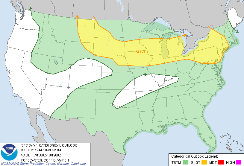
Back to our west-northwest, a mid level disturbance will be riding along the northern periphery of the building ridge axis. As it does so, it will help to trigger the development of thunderstorms — some of which could be strong to severe. These storms will initially form well to our north and west, but are expected to slide east-southeastward through the Northeast States as the disturbance shifts accordingly. Subsequently, the Storm Prediction Center has placed much of the area in a Slight Risk for severe thunderstorms.
The main question in regard to the potency of the severe thunderstorm threat is the degree of mid level wind support for organized thunderstorms. Initially, the best support for storm organization will be well to our west. This is expected to shift eastward with time, but may lag behind the developing storms this evening. As such, the thunderstorms may not be organized enough to produce a widespread severe wind threat.
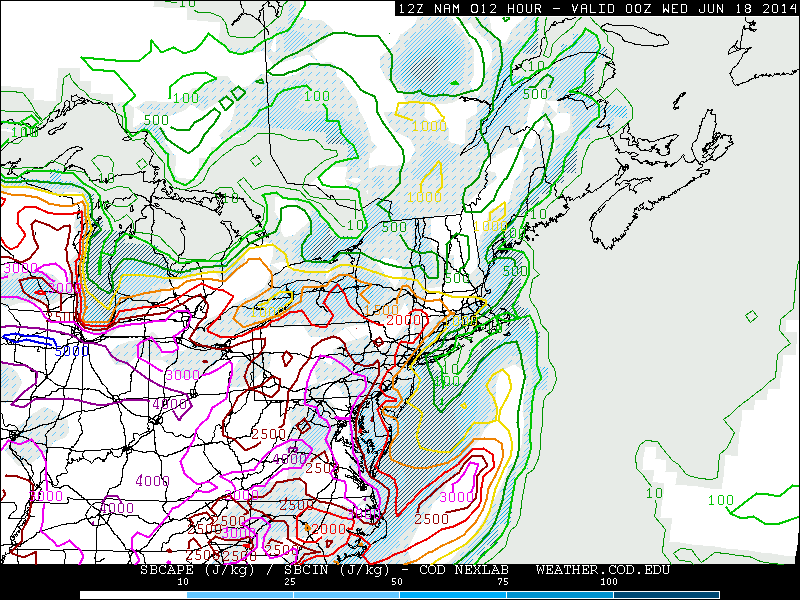
Moderate instability could fuel thunderstorms this evening.
Still, the potential for strong to severe thunderstorms is sufficient to trigger a Slight Risk and the storms which do eventually make it into our area will have the potential to produce frequent lightning, very heavy rain and strong winds. Additional storms are expected on Wednesday, and the Storm Prediction Center has placed our area in a Slight Risk for severe thunderstorms then as well.
The heat will continue on Wednesday, also, as the mid level ridge axis builds further toward our area while the gradient tightens a bit to our north. So hot air, rising humidity and an increasing likelihood of thunderstorms is expected once again.
Stay tuned for further details including any watches, warnings or advisories from the National Weather Service as well as additional outlooks from the Storm Prediction Center.
Thanks on your marvelous posting! I quite enjoyed reading it, you happen to be a great author.I will remember to bookmark your blog and will eventually come back from now on. I want to encourage continue your great job, have a nice day!
Heya i am for the first time here. I found this board and I find It really useful & it helped me out a lot. I hope to give something back and help others like you helped me.
It’s really a great and helpful piece of information. I am glad that you shared this useful info with us. Please keep us up to date like this. Thanks for sharing.
Nice post. I was checking continuously this blog and I’m impressed! Very useful info specifically the final phase 🙂 I care for such information much. I was looking for this particular info for a very long time. Thank you and good luck.
Some truly nice stuff on this internet site, I love it.
This is very fascinating, You’re a very professional blogger. I’ve joined your rss feed and look ahead to seeking extra of your great post. Also, I’ve shared your web site in my social networks!
I just could not depart your web site prior to suggesting that I actually enjoyed the standard info an individual provide for your guests? Is gonna be again regularly to inspect new posts
I conceive this website holds some very fantastic information for everyone :D. “When you get a thing the way you want it, leave it alone.” by Sir Winston Leonard Spenser Churchill.
Wonderful blog you have here but I was wanting to know if you knew of any community forums that cover the same topics talked about here? I’d really like to be a part of group where I can get comments from other knowledgeable people that share the same interest. If you have any recommendations, please let me know. Thanks a lot!