-2")
Seasons first heatwave, tropical threat this week
If you weren’t already convinced that summer had arrived, you will be by the end of this upcoming week. A building ridge is expected to set the stage for the seasons first potential heatwave (with temperatures of 90+ for three days or more) during the early to middle part of the week. Additionally, a tropical system may skirt the east coast by the latter half of the week into the holiday weekend. Don’t panic about your holiday plans just yet — models are still all over the place with the exact track of the system — but many of them are bringing it precariously close to the coast at this juncture.
Our hazardous weather begins, though, with the aforementioned heat wave during the early to mid part of the week. By Tuesday, a building ridge and rising mid level temperatures will help bring surface temperatures well into the 80’s — and likely 90’s — in much of the area. Southerly winds could keep things a bit cooler near the shore, but will pump in the hot air elsewhere. Rising dew points and humidity won’t help. Without a shadow of a doubt, it will feel like mid summer during this week.
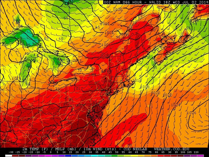
NAM model forecasting high temperatures in the 90’s on Wednesday.
Whether or not an official heat wave is reached by definition, the heat will last for several days before breaking toward the end of the week with an approaching frontal boundary. This boundary, however, will have impacts far more important than breaking the heat — it could sweep away a developing tropical system off the East Coast as well. Forecast models have been split with the development of the cyclone as well as the potential track of it.
Much of the uncertainty stems from the exact westward reach of the system initially (once and if it develops), the incoming trough and associated cold front, and a rouge area of vorticity some models have been focusing on over the Southeast States. These key features will have tremendous impacts on the eventual atmospheric play-out, and the sensible weather impacts in our area as well.
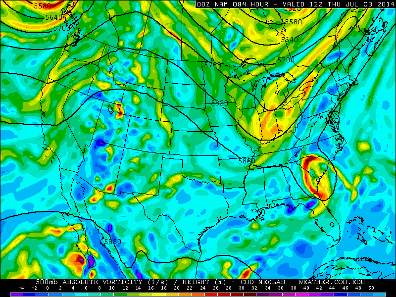
NAM model showing the tropical system off the southeast coast, and an incoming trough dangerously close to phasing with it and pulling it close to the Northeast US.
Should the system develop and track near the coast, the incoming frontal boundary could serve as a highway for moisture and precipitation leading to widespread rains. If the system develops and tracks east, hooking out to sea, there could still be a period of unsettled weather but our area would avoid the more major impacts.
It will take a few days to iron out the details of the atmospheric setup, as well as the eventual impact the system will have on our area — if any. So stay tuned over the next few days as we continue to analyze and interpret the forecast in regards to both the incoming heat wave and potential tropical system this week.
Leave a Reply
Want to join the discussion?Feel free to contribute!