-2")
Plummeting AO could offer some winter hints
As we’ve spoken about several times already this Autumn, our winter forecast doesn’t typically come out until the first week of November. Although some will bark at us for this — we’ve been hearing it already this Autumn — there are reasons for it. Mainly, our forecasters have recognized the importance of analyzing the pattern during October and the ideas moving into November. The recognition of the pattern during the next few weeks will be immensely important to understanding how things will shake down this winter. And our first “hint” could be offered during the next several days, as the AO — or Arctic Oscillation — is forecast to take a nose-dive.
The Arctic Oscillation is a large scale monitor of climate variability, also referred to as the Northern Hemisphere Annual mode. More simply, it’s a climate pattern characterized by winds circulating counterclockwise around the Arctic — typically at around 55°N latitude. In even more simple terms — the negative phase of the AO typically displaces cold air farther south in North America, while the positive phase keeps the colder air farther north, nearer to the poles and arctic regions. Forecast models are in good agreement that the AO will nosedive over the next several days — and not surprisingly, a major shot of below-normal temperatures is expected late this weekend into early next week.
But statistical analysis of just how far the AO drops can offer us some clues as to what the winter’s that typically follow tend to do. Forecast models currently suggest that the AO will drop below -2, and may even drop below -3. Such a sudden drop is impressive, and correlates well with the impending cold shot. But a drop below -2 and -3 isn’t unheard of during this time of year. In fact, it has happened before — and several times since 2002.
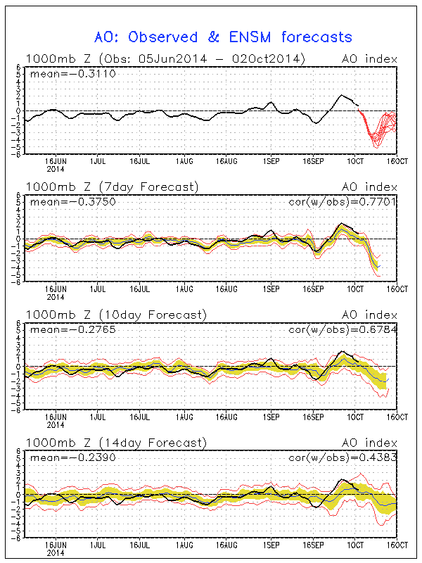
GFS model forecasting the AO to drop rapidly this weekend into next week.
When we take a look at the winters which followed, and their total snowfall in New York City, it becomes clear that there is at least a slight correlation between an AO below -2 in October and an above normal snowfall winter in New York City. The Arctic Oscillation dropped below -2 during the following Octobers since 2002: 2002, 2003, 2004, 2006, 2009, 2010, 2012. The winters which followed? They featured annual snowfalls which may catch your eye:
Winter 2002-2003: 49.3″
Winter 2003-2004: 42.6″
Winter 2004-2005: 41.0″
Winter 2006-2007: 12.4″
Winter 2009-2010: 51.4″
Winter 2010-2011: 61.9″
Winter 2012-2013: 26.1″
Average of winter since 2002 w/ AO below -2 in October: 40.6″
The average annual snowfall in New York City is right around 25″. Almost all of those above winters featured periods of below normal temperatures, as well.
But, wait. It’s not time to whip out the snow blower just yet. The data set is noticeably small — and there is still some variance in the results. This is just one piece of a large puzzle which we, as forecasters, have to piece together before getting an idea as to where this winter is heading. Analyzing and understanding information, however, as we move through October and November, will give us a leg up on what to expect once winter does begin.
Leave a Reply
Want to join the discussion?Feel free to contribute!