-2")
Gonzalo heads toward Bermuda as a dangerous Category 4
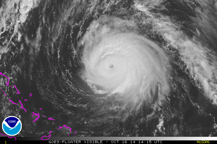
Hurricane Gonzalo strengthened into a Category 4 hurricane this morning, and has since strengthened further. Maximum sustained winds within the storm are 145mph as of 11am, with higher gusts. Most concerningly, the system continues to strengthen and organize as it heads northward. The hurricane will eventually take on a slight northeasterly heading, as it moves along the periphery of both an Atlantic ridge to its east, and troughing to its west over the Western Atlantic Ocean.
Most unsettling, obviously, is the forecast track of the system. Models are in good agreement that the storm will make the aforementioned turn, taking the center near or just west of Bermuda during the mid to late afternoon on Friday. This puts Bermuda in a precarious situation — the worst winds will shift to the east side of the system as it makes this turn. Maximum sustained winds are forecast to remain near 130 mph at the time the storm nears Bermuda.
The National Hurricane Center’s track of Gonzalo has remained consistent, but this is to be expected. Alarmingly, forecast models have remained quite consistent as well. Unlike many hurricanes and tropical systems over the past several years, Gonzalo is tracking along a highway between two major weather systems. The variability and interaction with other systems is somewhat minimized — and the models are honing in on the storms exact location during its pass on Bermuda without much fluctuation.
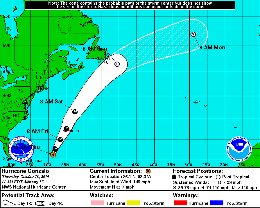
National Hurricane Center’s forecast track for Gonzalo.
The impacts on the island could be quite severe. The National Hurricane Center’s latest public advisory, as of 11:00am on Thursday, details the potential hazards which include severe wind damage, dangerous storm surge, and excessive rainfall.
WIND...HURRICANE CONDITIONS ARE EXPECTED TO REACH BERMUDA ON
FRIDAY...WITH TROPICAL STORM CONDITIONS BEGINNING LATE TONIGHT OR
EARLY FRIDAY MORNING.  IT SHOULD BE NOTED THAT WIND SPEEDS ATOP AND
ON THE WINDWARD SIDES OF HILLY TERRAIN ARE OFTEN UP TO 30 PERCENT
STRONGER THAN AT THE SURFACE...AND IN SOME ELEVATED LOCATIONS CAN BE
EVEN GREATER.

STORM SURGE...A DANGEROUS STORM SURGE IS EXPECTED TO PRODUCE
SIGNIFICANT COASTAL FLOODING IN BERMUDA.  NEAR THE COAST...THE SURGE
WILL BE ACCOMPANIED BY LARGE AND DESTRUCTIVE WAVES.

RAINFALL...GONZALO IS EXPECTED TO PRODUCE TOTAL RAIN ACCUMULATIONS
OF 3 TO 6 INCHES OVER BERMUDA.

SURF...LARGE SWELLS GENERATED BY GONZALO ARE AFFECTING PORTIONS OF
THE VIRGIN ISLANDS...THE NORTHERN COASTS OF PUERTO RICO AND THE
DOMINICAN REPUBLIC...AND PORTIONS OF THE BAHAMAS.  SWELLS WILL REACH
MUCH OF THE EAST COAST OF THE UNITED STATES AND BERMUDA TODAY.
THESE SWELLS ARE LIKELY TO CAUSE LIFE-THREATENING SURF AND RIP
CURRENT CONDITIONS.  FOR MORE INFORMATION...PLEASE CONSULT PRODUCTS
FROM YOUR LOCAL WEATHER OFFICE.
Preparations on the island are already well underway. While residents were still recovering from Tropical Storm Fay, which left some damage on the island, the recovery has shifted to evacuations ahead of Gonzalo. The Royal Gazette reported that “People stripped the island’s hardware stores of generators, batteries, candles and other items and picked up free tarpaulin distributed by the government.”
More: Satellite images of Hurricane Gonzalo
Bermuda’s airport is set to close on Thursday night. Representatives suggest the airport main remain completely shut down until Sunday. Over the next 24-48 hours, we’ll continue to update on the storms movement and strength — as well as its pass near the island on Friday. For the latest forecasts, data, and discussions, visit the National Hurricane Center.
Leave a Reply
Want to join the discussion?Feel free to contribute!