-2")
Cold arrives, period of snow follows Thursday Night
The warmth is over. A surface cold front moving through the Northeast US has reached western and central parts of the forecast area this afternoon, and it will continue to slide eastward tonight. Southeasterly winds, which brought in fog and drizzle as well as warm temperatures in the 60’s this morning, will flip to drier northwesterly winds, and a colder airmass will surge in. Forecast models are in good agreement that temperatures will drop this evening, well into the 30’s overnight tonight. But the core of the cold airmass moving southward won’t settle into our area until this weekend.
It’s not until Thursday afternoon, when a secondary cold front passes eastward, that the surge of cold air will become noticeable. Northwest winds will become blustery and temperatures will struggle out of the 40’s for highs. But more notably, high clouds will begin to increase from the southwest. The culprit? A weak disturbance riding along the front which will, by Thursday night, be to our southeast. The disturbance will kick off a very weak low pressure system in the Western Atlantic. Weak lift for precipitation will pass over our area on Thursday Night — supporting the development of some precipitation.
Although expected to be showery in nature, there is good agreement among models that precipitation will in fact fall overnight on Thursday. With mid level and low level temperatures rapidly dropping behind the front as cold air advection strengthens, snowflake formation may be supported by late Thursday Night into the early morning hours on Friday. This snow could fall from the interior to, yes, even parts of the coast as the system passes quickly northeastward.
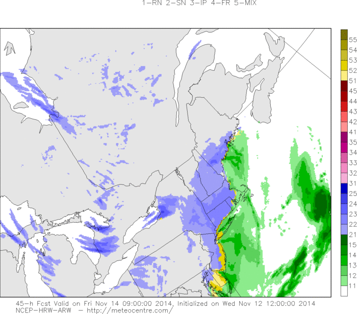
HRRR model showing a period of light snow as a coastal storm pulls away from the area Friday morning.
The general progression of the system, and marginal thermal profiles, suggests that accumulations are extremely unlikely. Still, roads could become slick for a period of time where any frozen precipitation falls and temperatures fall. By Friday around lunchtime, skies will be clearing out and the brunt of the cold air will be settling in to the area. 850mb temperatures will fall from -4 Thursday Night to -10 on Friday night, with clearing skies and light winds.
As a result, low temperatures in the 20’s are anticipated on both Friday morning in the interior and Saturday morning area-wide. It will certainly feel like early winter by the time this weekend rolls around!