-2")
First snow of the season tonight for many
No, this is not going to be a crippling winter storm. But the first true taste of winter is on its way tonight, as rain is likely to change over to snow in most locations.
A few days ago, most computer modeling data had little-to-no precipitation at all for the area. But that has changed over the past few days, as guidance has picked up on a few features which will increase the dynamics of the atmosphere tonight.
A potent mid-level disturbance is moving through the Great Lakes and into Western Upstate NY. This helps to strengthen the jet stream in New England over 130 knots, which helps to favor lifting in the atmosphere for precipitation. Additionally, this disturbance is triggering another shot of cold air advection, which is running into the warmer Atlantic Ocean, which also aids in the development of precipitation.
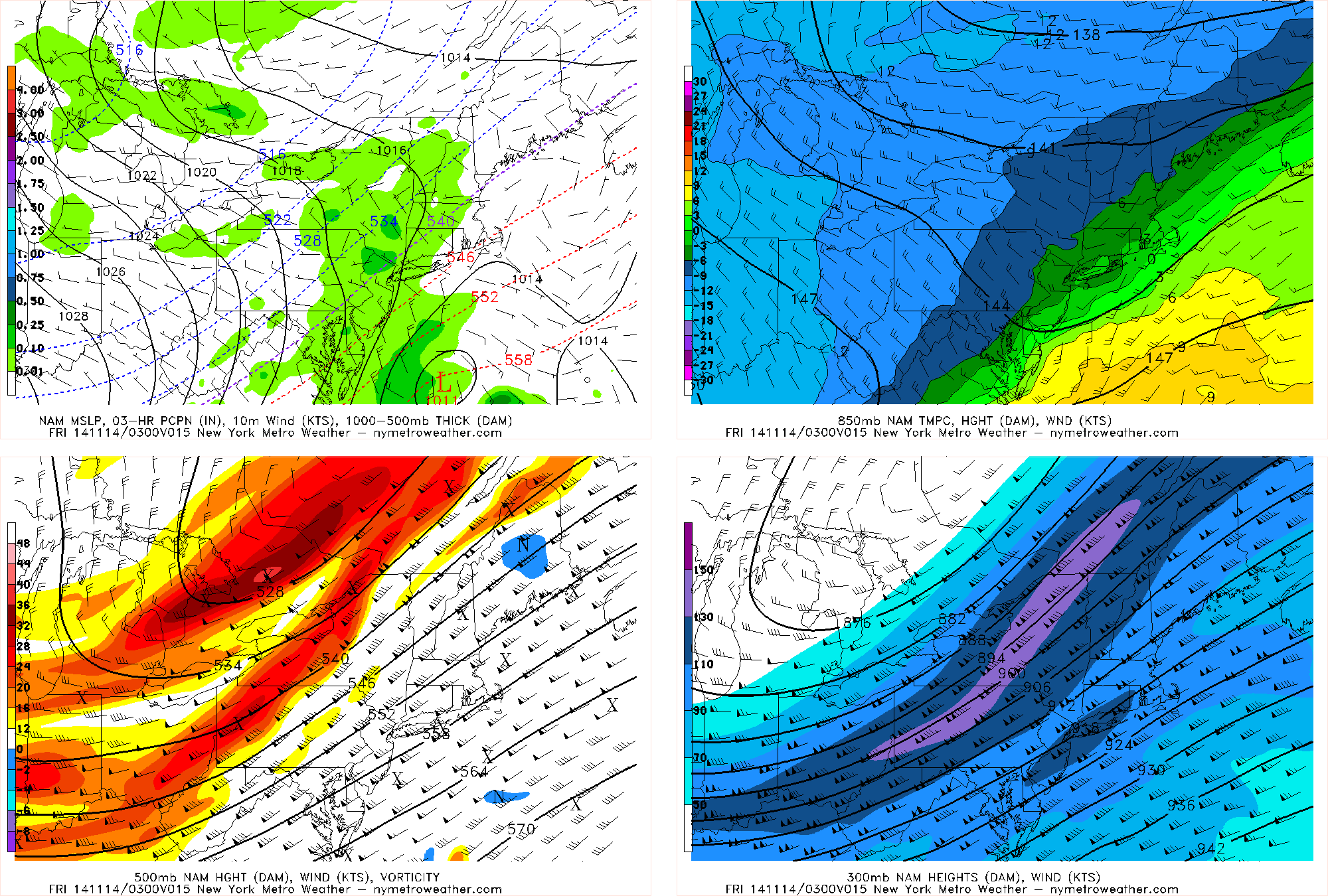
Today’s NAM Model valid for 11:00pm shows precipitation breaking out in response to a potent mid-level disturbance.
Another subtle feature which is helping the precipitation breaking out is a secondary jet-stream maximum right over New Jersey and Long Island — that favors lifting for precipitation just offshore, which could have been a feature the models had previously missed.
Also of note is the fact that at 850mb (top right panel), there are westerly winds, bringing in much colder temperatures. This will help to allow any rain to change over to snow. Just offshore in the warmer Atlantic waters, however, the 850mb winds are southerly, pumping up warm air. When colder temperatures are being brought into a cold area, and warmer temperatures are being brought into a warm area, and these two areas are compressed together, you get a pseudo-frontal boundary — which also helps to generate precipitation. The technical meteorology term for this is called Frontogenesis.
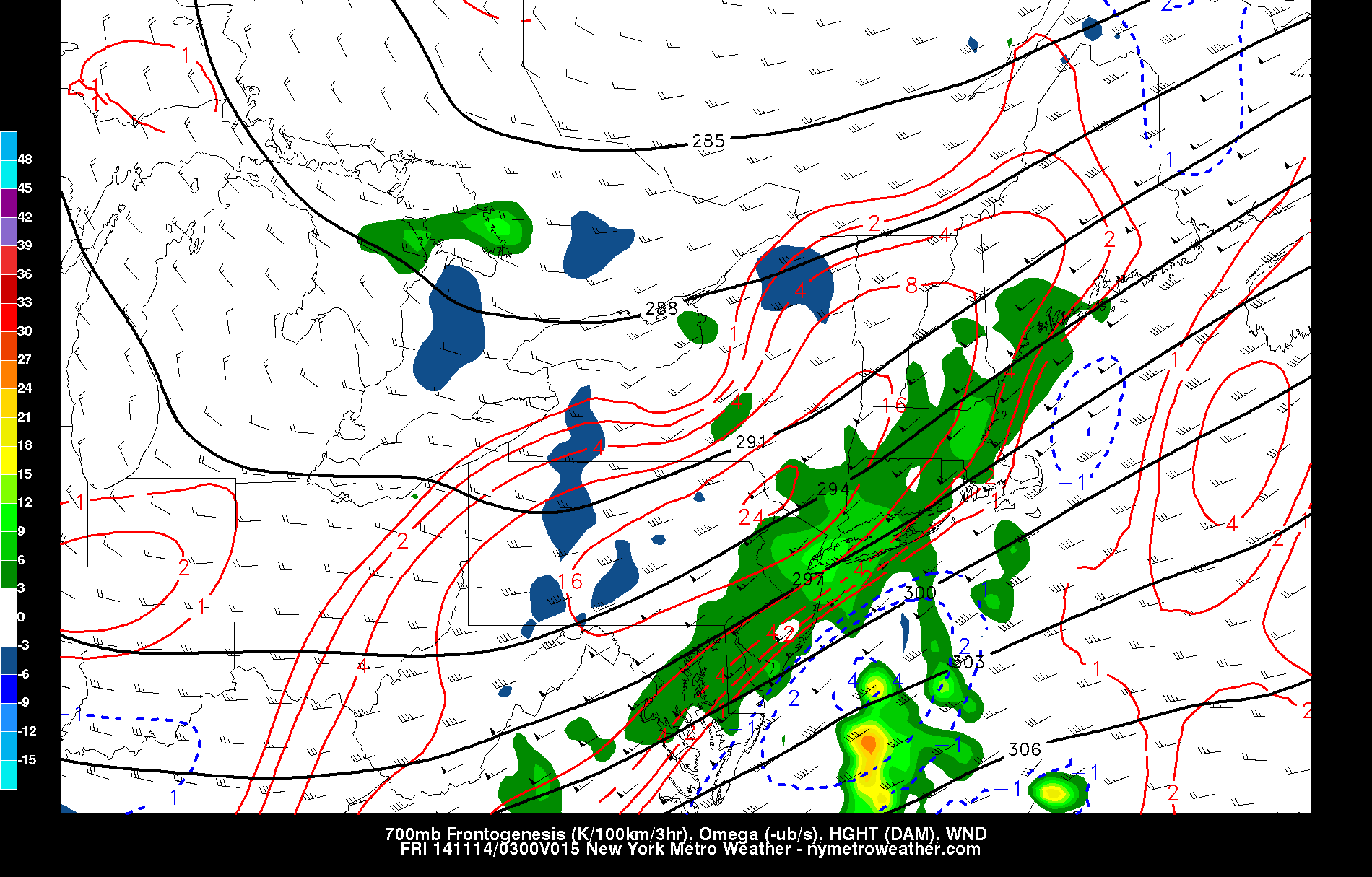
Today’s NAM Model valid for 11:00pm shows high frontogenesis values (red contours) as well as good lifting (omega) in the atmosphere (shading).
These features are impressive enough for us to believe in light to moderate precipitation falling from around 8:00pm through most of the overnight. The lack of a truly organized storm system off the coast will prevent widespread heavy precipitation, however, so most locations will probably see anywhere between two tenths and four tenths of an inch of precipitation.
Overall breakdown and what to expect: Precipitation will start off as rain for most of the area, but the big question is when the changeover to snow occurs. N NJ, the Hudson Valley, and SW CT could see a transition as early as 10:00pm. Westchester, NY and other suburbs in NJ may changeover between 11:00pm and midnight — though nailing down the exact hour is still has some uncertainty.
Surface temperatures will generally be staying just above freezing throughout the night, so snow may have a tough time accumulating. As is typical in borderline-temperature storms, accumulation will be dependent on precipitation intensity — heavier precipitation cools the surface via evaporation and can accumulate faster than it melts. Lighter precipitation will not accumulate much at all.
Because of the potential for some moderate to heavy bursts of precipitation, a coating to an inch of accumulation on cold surfaces is possible in most suburbs, especially considering temperatures just above the ground are supportive of snow falling. There may be a few locations in the N NJ, the Hudson Valley, perhaps even parts of Westchester, and SW CT who pick up more than an inch of snow, but that will be localized.
For NYC and immediate coastal areas (including Long Island), the changeover is most likely to occur somewhere between midnight and 3:00am. Although temperatures just above the ground support snow falling, surface temperatures may stay in the mid to upper 30s, preventing accumulations. Still, though, any heavier burst of snow could coat the grass and car tops. Some of the hills in northern Long Island could get a half inch to an inch of snow.
Any snow or mix of rain and snow should end between 4:00am and 5:00am.
Fortunately, roadways will mainly remain wet, since temperatures will probably not fall below freezing until precipitation ends for most locations. Still, though, a bit of caution and extra time may be needed in some areas during the early-morning commute, and roads could be a bit more treacherous and slushy in some northern suburbs.