-2")
Record breaking cold makes its presence felt
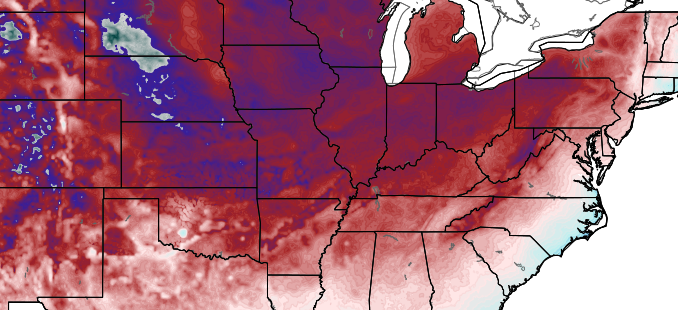
This was the coldest morning in the United States since 1976. How’s that for a statistic to start your day. The average temperature in the United States fell to 19.4 F at 12z this morning, beating the 19.9 F average reading from 1976. That average temperature is simply a statistical testament to the breadth and intensity of the cold air which has surged into the United States this week behind a powerful storm system and associated cold front. Temperatures were in the single digits this morning throughout much of the Central United States, and in the teens all the way through the Ohio Valley and Northeast. A remarkable 85.3% of the United States was below freezing, and 58.2% below 20 F.
In our local area, the cold surged through Monday Night into Tuesday morning and made its presence felt immediately. Temperatures fell easily below 30 F in New York City’s Central Park. This was the first time this season that the park fell below freezing. Wind Chill values were in the teens and single digits with blustery west-northwest winds blowing from 10 to 20 miles per hour. Today will be a winter-like day in the truest sense. High temperatures will struggle past the freezing mark (although the actual “daily” high temperature will be 45 F which was registered at midnight in NYC). Wind chill values will remain in the 20’s. And the westerly winds will continue surging cold air into the area tonight, when temperatures will fall even further.
Newer high-resolution forecast models suggest temperatures will fall into the teens tonight, even in New York City and near the coast. Inland, lower teens are likely for low temperatures. Wind chill values will fall into the single digits there. Blustery west-northwest winds will continue during the daytime hours, with calmer and just simply cold conditions during the evening and overnight hours.
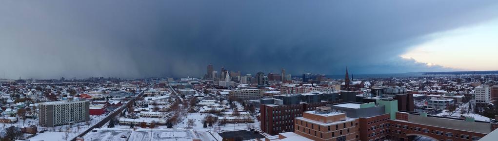
From the “it could be worse” department, today, we look just a few hundred miles to our north and west. The combination of extremely cold air aloft, the surge of cold air advection, and warmer air/some moisture along the Great Lakes is leading to an epic turn-on of the Lake Effect snow “machine”. Extremely heavy bands of snow sat south of Buffalo and near Watertown, New York this morning producing snowfall rates of 3-4″ per hour at times. The bands were visualized on regional radar, barely moving but fluctuating somewhat from north to south.
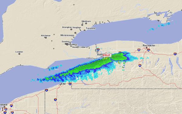
Radar imagery from Tuesday morning showing a band of heavy snow south of Buffalo.
The National Weather Service was forecasting snowfall amounts over 24″ in areas which sit underneath the heavy bands of snow. Meteorology enthusiasts flocked to the area ahead of the snow band — yes, people actually chase Lake Effect Snow” to capture imagery of the event as it unfolds. Marc Stewart, for example, captured this incredible imagery of the band over the south side of Buffalo (seen in the above radar imagery) and posted it to WBZ.
Luckily, for now, our area looks to escape the snow. The next chance for frozen precipitation in our area won’t come until Thursday, when a band of light snow may pass overhead. But moisture will be lacking and no organized low pressure system is expected to aid in the development of precipitation. By this weekend, the airmass will begin to modify and temperatures will rebound toward more “normal levels”. Precipitation that comes in the following days will likely fall in liquid form.
So, we can hang our hats on the fact that we were able to escape this shot of arctic air without any significant snow. Not sure we’ll be able to say the same as we move into winter.