-2")
Multi-hazard Nor’Easter expected Tuesday
A significant storm system, characterized by a deepening low pressure with prolific moisture, will move from the Western Atlantic to a position very near New York City on Tuesday. As a result of a mid level atmospheric phase, the storm system will feature intense mid and upper level dynamics. The system is forecast to strengthen with a minimal central pressure near 1012mb today, falling into the mid 990’s mb by Tuesday. With a storm track near our area, and the dynamics involved in the system, multiple weather hazards are anticipated both near our area shores and even inland throughout the interior portions of the area.
Precipitation could begin as early as Monday morning along the coasts of New Jersey and New York as moisture streams inland, owing to an onshore flow. But as the storm system is tugged inland from the Western Atlantic, as a result of the phase in the mid levels of the atmosphere, warm air advection and increased moisture will surge heavier and steadier precipitation toward the coast and eventually into New York City, New Jersey, Southeast New York and Connecticut. Enough low level cold air could hold on across the higher elevations of the interior to allow precipitation to begin as snow, sleet or freezing rain — but this will only be brief as mid level and low level warming transitions precipitation to rain quickly.
The event will create multiple potential hazards throughout our area on Tuesday as the low pressure system tracks nearby. We’ve broken them down here.
Heavy Rain/Flooding
With the approach of the low pressure system, and the evolution of a mid and upper level atmospheric phase, will come the potential for prolific rainfall, very heavy precipitation and flooding in some areas. Intense lift in the atmosphere will surge northwestward from the low pressure system as it moves near our area later on Tuesday. Initially, moderate rainfall will spread through New Jersey, New York and Connecticut on Tuesday. But Tuesday afternoon, an area of enhanced lift will spread north as a result of mid level frontogenesis.

NAM model showing strong lift in the mid levels producing a band of very heavy precipitation over NJ and NYC Tuesday.
Within this area of heavier precipitation, very heavy rain is likely with low visibilities, strong gusty winds and possibly a rumble of thunder. This band will be strongly forced — so on both sides of it, lighter precipitation rates are expected. We see this often, and the best way to describe it is a “Balancing act” in the atmosphere. The intense lift within the band must come down around the band — hence, subsidence and lighter precipitation. Additionally, just to the south of this band will be a mid level dry slot. So as the band moves northward, precipitation will lighten considerably after its passage.
Flooding concerns are obvious: With prolific and heavy rainfall, urban flooding is possible — as well as flooding of poor drainage or low lying areas. Near the coasts, the problem could be further compacted by the onshore flow, high tides and rainfall. Areas which typically experience coastal flooding are likely to experience it during this strong Nor’Easter as well. Some beach erosion is also possible — owing to the tides, rain and strong winds.
Strong/Damaging Winds
The system moving through the area will feature impressive dynamics in multiple levels of the atmosphere. As the low pressure system passes close to the area, a strong low level jet will surge northward. Forecast models suggest the potential for winds to exceed 65 knots at the 925mb level (2500 feet above the surface). However, a noticeable inversion is present in the lower levels of the atmosphere which should generally prevent these winds from mixing down to the surface.
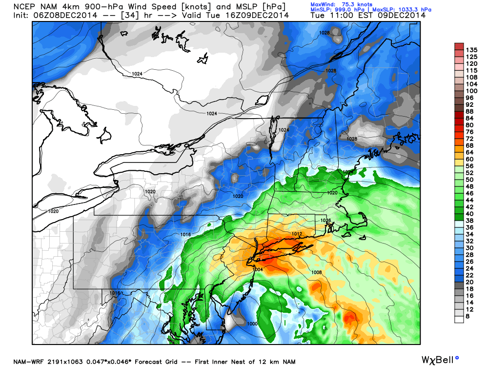
NAM showing strong winds at 900mb passing over the area at 18z Tuesday.
Still, the nature of the heavy precipitation and the strength of the onshore flow suggests that wind gusts could occasionally exceed 45 miles per hour especially near the areas coasts. The easterly winds, as the storm passes near the New Jersey Shore, could cause coastal flooding and beach erosion on the shores of New Jersey and Long Island.
As the heaviest rain and lift move over the area on Tuesday afternoon, dynamics could mix down the aforementioned winds at times — bringing strong wind gusts to much of the forecast area. The National Weather Service has, accordingly, issued a High Wind Watch for many coastal areas including New York City.
Snow and Wintry Precipitation
By nature, this storm won’t feature prolific snowfall in our area as a result of the strong warm air advection occurring at multiple levels of the atmosphere. Still, the atmospheric profile is very cold to start on Monday. So, across the interior and higher elevations of Northwest NJ and Southeast New York, a period of snow or mixed precipitation is possible as the storm begins. But as precipitation gets heavier, any wintry precipitation is expected to rapidly transition to rain.
The wintry precipitation discussion rears its ugly head once again as the storm system begins to move farther northward and the strong warm air advection has ended. After the phase in the mid and upper levels of the atmosphere, colder air will begin to work back into the atmospheric profile at all levels. But a dry slow at 700mb will have moved into the area — meaning snowflake production won’t be very easy to come by.
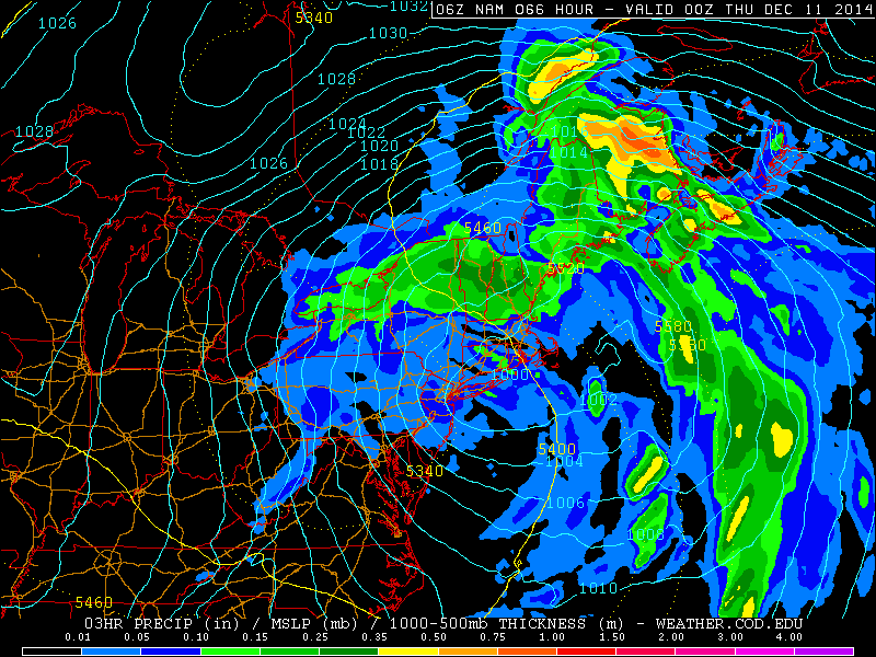
NAM model showing snow in NJ/NYC Wednesday as the storm pulls away.
Still, models show the mid levels becoming more moist once again as the upper level low drifts over our area later Tuesday into Wednesday. What ultimately could occur is that bands of precipitation will re-develop on the southwest side of the surface low. Although not prolific or heavy precipitation by any means, these bands could produce additional periods of rain or snow as they move northeastward through the area.
The chances for snow are highest across the interior and higher elevations, of course. But forecast models recently have indicated a chance of a period of snow even down to Northeast NJ and New York City.
Overview
Stay tuned here, and to our social networks over the next day or two for further updates regarding in the impending Nor’Easter and the multiple hazards which it is expected to bring to our area. We will be starting a Live Blog later this afternoon which will feature up to the minute information from our meteorologists.