-2")
Seasonable pattern to gradually transition to cold and active
Yet another period of rain hit the area last night, which has been a staple of the weather pattern this month. No big Arctic air intrusions as the Arctic air has remained bottled up near the Poles, and plenty of rain. Today was a mild afternoon as westerly flow in a merely stale chilly airmass led to downsloping flow and temperatures in the low 50s. Temperatures so far this month have actually been running around seasonable or only slightly above normal, but without true plunges of cold air and warmth in Canada, snow has been hard to come by.
This theme is expected to continue for the next week or so as the pattern finally truly shuffles and transitions to one where Arctic blasts are much more frequent across the US. But in the transition period itself, snow is generally still tough to come by.
Cold air advection will finally take shape tonight as temperatures aloft drop. But in a stale airmass, temperatures will generally only fall to around freezing in suburbs, and mid 30s in urban areas. This is a few degrees above average.
Moving forward to tomorrow, the airmass will be moderately chilly, but once again a northwesterly flow will downslope and help temperatures warm into the mid to upper 40s for most regions. Skies will remain mostly sunny throughout the day, with perhaps a few more clouds during the afternoon — though not a true overcast like we saw this afternoon. It will also be a bit blustery at times as well, with winds between 10 and 20mph.
Seasonable temperatures are expected to continue during the next several days. Tomorrow night will have low temperatures a few degrees colder than tonight, with lows in the upper 20s in suburbs and low 30s in urban areas. Friday and Saturday will feature highs in the low 40s with partly cloudy skies.
What had initially looked like a big storm system for Sunday has since greatly fizzled into only a weak disturbance which will most likely pass seaward.

Today’s GFS model valid for this weekend shows a weak wave passing to our south, with continued mild readings for much of the US. Notice how the Pacific Jet is slamming into the NW US in the bottom right panel.
This is because the strong Pacific Jet that has continued to blast the US with mild air, a progressive pattern, and plenty of rain in California and much of the west coast will continue to wreak havoc. It will prevent a ridge from building in the west, which would have amplified the pattern enough for strong waves of energy to merge together and come up the east coast as it slid underneath a Rex Blocking pattern in SE Canada. Instead, the waves of energy remain quite weak and not much in the way of cold air has access to the US, leading to a weak wave which will probably pass seaward. Most likely, increasing clouds with perhaps some scattered showers are possible in most of the region on Sunday and Monday, with maybe a few snow showers inland on Sunday and rain showers on Monday. Temperatures will continue to be in the low 40s for highs.
The bigger changes could be occurring as we head towards Christmas Eve. Forecast models are in good agreement on a full-latitude trough, and in a transition regime, that often can spell a big storm that can finally start to usher in the cold air. However, in these transition regimes, full-latitude troughing generally means that the storm will cut too far west to be a snowstorm, and instead be a heavy rain and wind maker on Christmas Eve — essentially a Grinch Storm.

Today’s GFS model valid for Christmas Eve shows a very large storm system cutting to our west, with extremely impressive drops in pressure. While this will most likely bring heavy rain and strong winds, it may finally be the trigger that sends us to a colder and snowier weather pattern afterward.
Of course, that storm is still a week away, so details are a bit murky. But the weather pattern and all guidance does support a large storm system of some kind. Moving forward, a colder and snowier pattern could settle in.
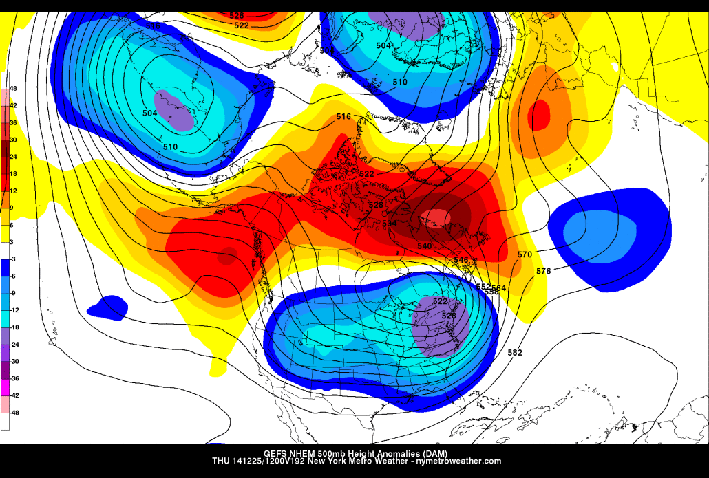
Here are the GFS ensembles valid for Christmas morning.

The GFS ensembles valid for Christmas morning show the “bomb” storm system helping to pump up strong ridging just south of Greenland, which is a classic way to transition into a -NAO pattern. Additionally, ridging builds in Alaska and the Gulf of Alaska, instead of bouts of troughing and Pacific air. This could lead to a cold and snowy pattern.
What the GFS does is a classic “wave-breaking” event, where the large storm system is so strong that it essentially breaks the wave train in the North Atlantic, and causes a large wave of ridging to form out ahead of it. In this case, this large ridge could turn out to be a block in the NAO regions — a strong -NAO pattern. When this is combined with changes in the North Pacific — a ridge building into Alaska which somewhat connects with the NAO ridging, then the tables can really turn towards a colder and snowier pattern. Arctic air can slide on the downward side of the EPO ridge into all of southern Canada and the US — a much colder pattern.
Of course, there are uncertainties as to how long the -NAO pattern will last, and details are still a bit murky. But the pattern shown above with lingering southern stream energy from the El Nino and Pacific Jet energy in the background could lead to lots of waves of energy cutting underneath the EPO ridge. Thus, there could be a train of energy entering the southern US in a much colder US pattern, with at least somewhat of a -NAO to help them ultimately take favorable tracks for snow. The first wave of energy that arrives after this pattern shift could still be more wet than white (but could also be snowy if the NAO block takes hold right away), but as we approach December 28th and onward, the pattern — as of now — looks much more favorable to consistent cold and some snow chances, and perhaps even a “biggie” could be in the cards.