-2")
Clipper on Tuesday to be followed by Arctic Blast
Is winter finally arriving? The 50-degree weather and rain we’re currently having certainly doesn’t signify that, but the weather will be turning much more wintry starting tomorrow and potentially lasting for one week or longer. On the back side of the current storm system, a cold front has formed and will be approaching us this afternoon. Southwesterly winds will be increasing and temperatures will generally be in the mid 50s. There is the chance of another downpour during the mid-afternoon, before the cold front crosses this evening, creating a dramatic shift to our weather.
Winds will shift to the northwest from 15-20mph and will gust to around 30mph at times. Temperatures will plummet into the upper 20s and low 30s tonight, with Wind Chills in the low 20s. The continued cold air advection tomorrow will not allow temperatures to get out of the mid to upper 30s tomorrow afternoon. That in itself is certainly not brutal, but it’s a huge change from what we’re seeing today. On the bright side (no pun intended), there will be sunshine tomorrow.
The next feature to watch will be a weak Alberta Clipper for Tuesday. On Monday night, a cold high pressure system will be building in, bringing in a reinforcing shot of cold air, with low temperatures in the upper teens to lower twenties. This will allow temperatures at the surface, and particularly aloft, to be plenty cold for snow.
At the same time, a pretty potent shortwave will be traversing the Midwest and head for our area.
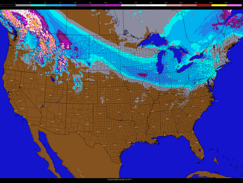
Today’s GFS model valid for overnight Monday night shows a shortwave in the Midwest. It will weaken as it approaches, but still bring light snow on Tuesday. (Weather.cod.edu / Nexlab)
If that shortwave were to maintain its strength, the entire area would be looking at a 2-4″ snowfall for Tuesday. However, guidance has been consistent with weakening the shortwave as it approaches, allowing it to become more broad and less consolidated. This means that a 2-4″ snow event is unlikely. But with temperatures being plenty cold on Tuesday, it will not take much precipitation to lead to 1-2″ of snow, given that it should be fluffier in nature with higher than 10:1 snow-to-liquid ratios. There may also be an attempt for the clipper to grab some Atlantic Moisture at the very last second and throw some back into our area.
Today’s NAM model’s snowfall forecast for the clipper. Notice how snow amounts are a bit less as you head east, but still could be in the coating to 2″ range. (PSU E-Wall)
That all being said, without upstream blocking to slow the storm down, most of the Atlantic Moisture grabbing will stay offshore, and thus the weakening trends will be enough to prevent major impacts. But a general coating to 2″ of snow for the area appears to be in the cards on Tuesday. Combined with the bitterly cold air that will follow, it will finally feel like winter.
A potent piece of energy aloft behind the clipper will consolidate and perhaps trigger some ocean-effect snow showers on Wednesday, with high temperatures only in the mid 20s. This energy has a direct source region from the Arctic, and will be plunging in a north-to-south trajectory. That is the most efficient vector for driving cold air into our region. 850mb temperatures (about 4,500 feet above sea-level) will be dropping to around -25C, which easily supports single-digit lows, and some interior areas to rival 0-degree lows.
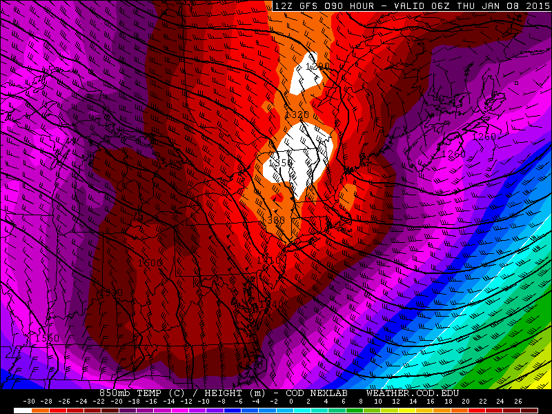
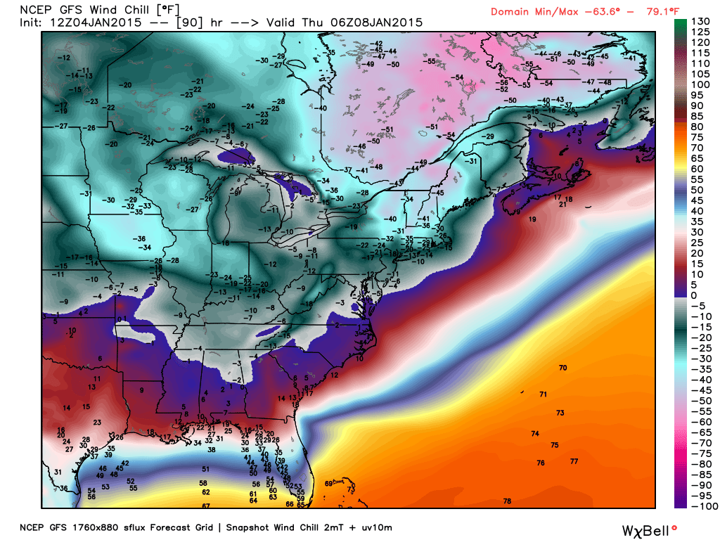
Today’s GFS model valid for 1:00am on Thursday morning shows 850mb temperatures (about 4,500 feet above sea level) falling between -25 and -28C. That easily supports temperatures in the single digits to near zero. (Weather.cod.edu / Nexlab)
As of now, we are forecasting lows between 4-8F on Thursday morning, with temperatures between 0-4F in north and west suburbs. Wind Chills could run anywhere between -10 to -20F.
High temperatures will most likely only hold in the mid teens on Thursday, giving us a harsh reminder that it is January, and winter has returned.
Another weak clipper system could pass to our north on Friday, giving us more snow showers and a reinforcing shot of cold air.
Once tomorrow comes around, we might not go above freezing again until late next weekend or early next week. We are also watching a storm system in that timeframe — when Arctic air is departing, energy on the backside often has room to come up to our area and drop snow in the cold air that is left. That timeframe is very far out, though, so uncertainty is quite high.