-2")
Significant coastal storm could affect the area this weekend
If you hung your hat on a quiet and benign winter after the slow start to December and January, you may want to rethink things. Forecast models are in good agreement on a significant coastal storm — yes, a Nor’Easter — impacting the area this weekend. The storm is likely to form as a result of a significant mid level atmospheric disturbance, which will shift from the Four Corners region of the United States northeastward through the Mississippi Valley and eventually off the coast of the Mid Atlantic States.
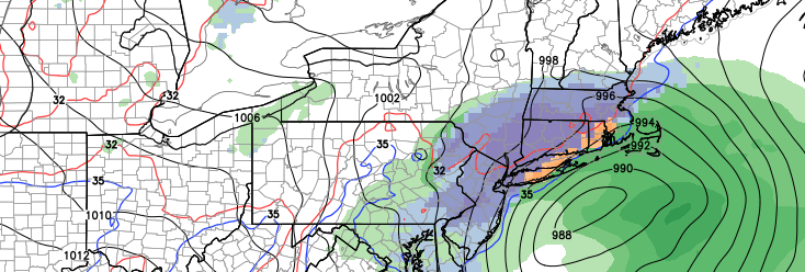
The disturbance will force the development of a strong low pressure system, which will shift from the Carolina coast to a position off the Mid Atlantic States and eventually a position near the 40/70 Benchmark on Saturday evening. Forecast models, however, remain somewhat undecided as to the evolution of the energy in the mid levels of the atmosphere — and the evolution and strength of the surface low as it moves up the coast. Obviously, this will have a major impact on the conditions that our area experiences including precipitation type and intensity.
The potential for a significant winter storm? It certainly does exist. Some forecast models indicate a rapidly strengthening surface low off the coast of the Mid Atlantic moving to a position just Southeast of New England. Such a scenario would result in significant precipitation in our area, falling as a result of a strengthening cold conveyor belt, and resulting in strong dynamic cooling and the potential for significant snowfall.
Is this scenario likely at this time? It’s hard to say — but we’ll lean against a straight-up winter storm at this time. There are a few reasons why. First of all, the antecedent airmass isn’t necessarily “textbook” for East Coast winter storms. Mid and low level temperatures aren’t extremely cold, and the storm system’s track could help to funnel in some warmer air.
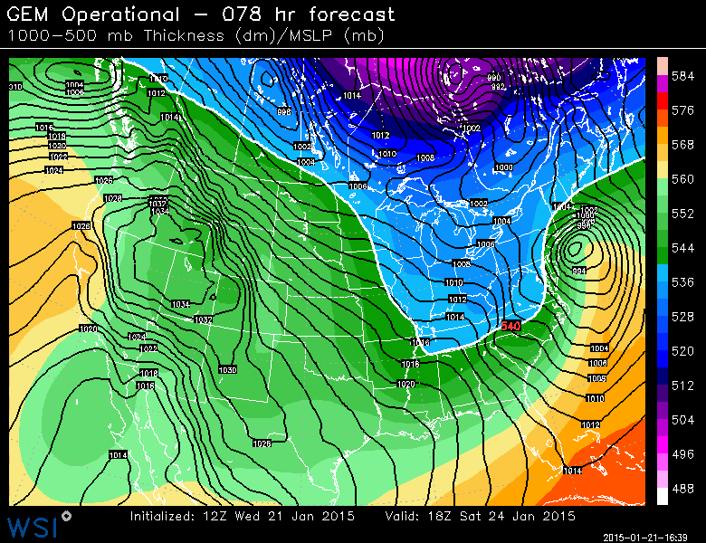
Canadian model showing a significant low pressure system off the coast of New Jersey on Saturday.
Second, the storm system doesn’t have a strong high pressure to its north while it is developing. While this certainly isn’t a requirement for East Coast winter storms, it does make things easier if you’re looking for snow. Instead, we have a low pressure system driving northward toward James Bay in Canada. As a result, we get a southerly flow and some warm air in the mid levels while the storm is developing. Dynamics can cool the column eventually, but some precipitation looks likely to be lost to freezing rain, sleet, or rain during the storm.
What is causing the variance among model solutions?
In regards to the storm system itself, the variance has lessened greatly over the past 24 hours. Forecast models are now in very good agreement that a significant storm system will take shape off of the East Coast this weekend. The variance has more to do with the individual nuances in the mid level flow, and the track of the storm system itself. The exact track of the storm will have major impacts on our sensible weather.
Some forecast models agree that the storm system will take a favorable track for winter weather in our area — because the mid level energy and low centers will be organized. This gives the cyclone time to mature and, by the time it reaches our area, cold air has funneled into the storm as a result of strong dynamics and plowable snowfall is likely.
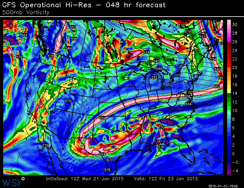
GFS model showing a more strung out, elongated piece of energy in the mid levels of the atmosphere. This would result in a weaker storm this weekend, tracking far enough east so that our area avoids major impacts.
Other models are less organized with the mid level centers — and the track of the system brings warm air into the mid levels of the atmosphere. So although some snow would still be possible, freezing rain, sleet and rain would significantly mitigate snowfall totals especially near the coast. The low pressure system wouldn’t deepen rapidly until it was well past our area to the north and east.
These two distinct possibilities lead to low confidence amongst forecasters. The models are essentially split at this time frame in regards to the evolution of the storm system — and forecasters will have to carefully monitor trends over the next few days to attempt to understand how the system will pan out.
What hazards are expected this weekend?
The hazards expected will be determined by the exact track and intensity of the surface low, as well as the placement and orientation of precipitation. At this time, multiple hazards are possible; including heavy snow, hazardous roads and travel, freezing rain, sleet and gusty winds. At this time, it is too early to pin down exact details and specific locations where the worst impacts are expected.
The most advantageous thing to do at this point is to continue to monitor the forecasts. By Thursday morning and afternoon, our meteorologists should have a much better idea as to what to expect — including impacts and hazards as well as accumulations and timing. Additionally, stay tuned to our social media accounts for up to the minute information.