-2")
The meteorology behind this weekend’s Nor’Easter
This winter has not had a fair share of wintry events. The snowfall we have received has generally come from clipper systems, and the larger storm systems have been rain. But the weather pattern is changing towards one that favors major east coast storm development and potentially large snowfall events. It is not a slam-dunk by any means, since there are a lot of moving parts, but the pattern over the next few weeks certainly piques the interest of any meteorologist looking for potential winter weather events.
One of the main problems for getting major snowstorms this winter has been the very fast flow across the Pacific and Atlantic basins. This means that any large storm that tried to amplify would get flattened out, as any ridging in the Pacific would get flattened like a pancake. This is going to change as we head towards this weekend.
Initially, the ridging out west is getting beaten down again. If the storm were to try heading towards us right at this time, it would have no chance to come up the coast. However, the big thing that has changed is that there is now a phase between two streams of energy out west. That allows for one much stronger impulse of energy to dig south towards the 4 corners, while other weaker energy quickly scoots to the east and gets out of its way. Afterward, the ridging along the west coast rebuilds — since the energy is stronger and gets left behind, it now is slowly ejecting and getting stronger in a weather pattern that has more amplified ridging out west.
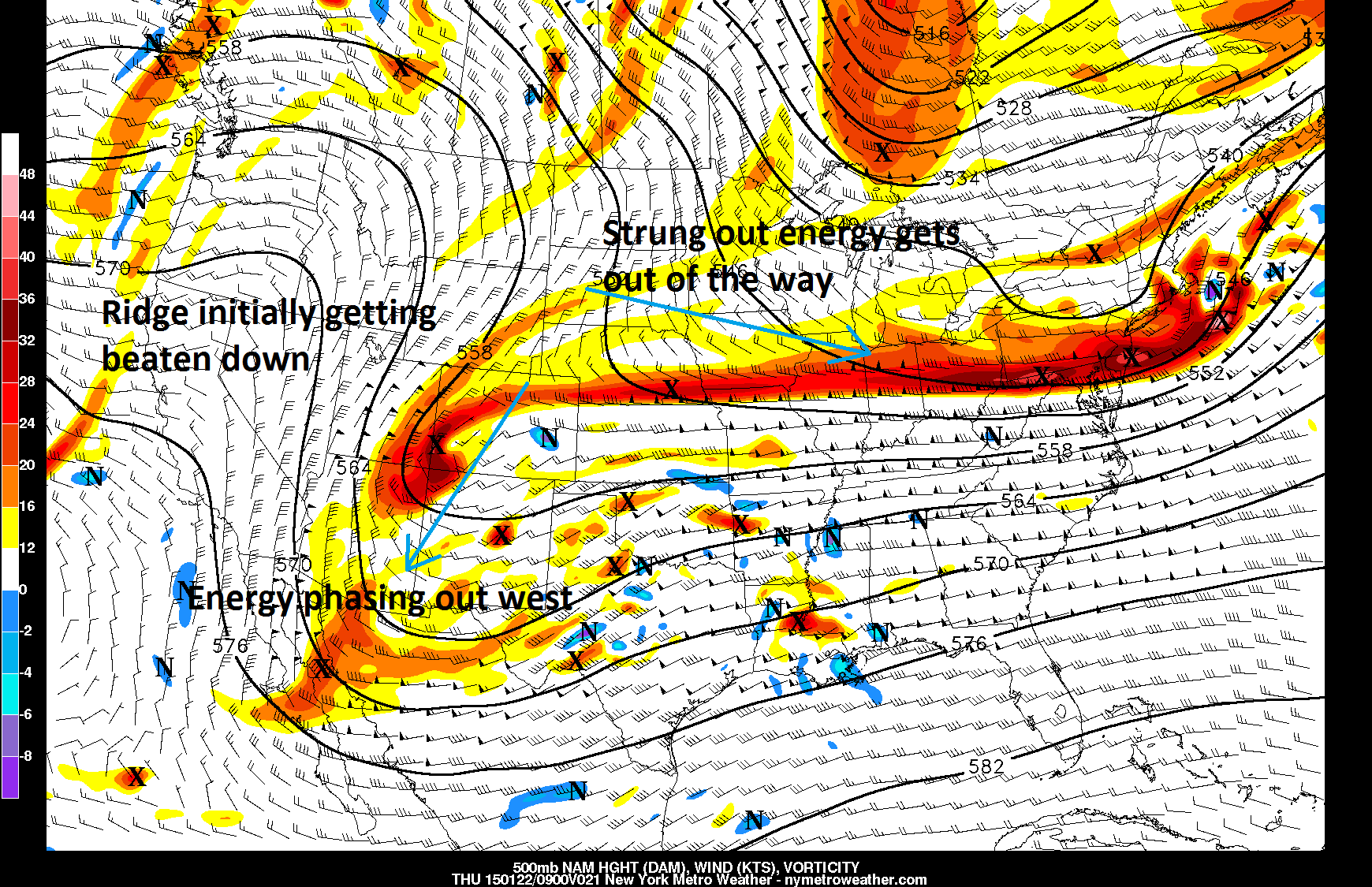
Wednesday’s NAM model valid for 4:00am shows the beginnings of an interesting storm setup.
The energy phasing out west slows down the pattern, and gives more time for the strung out energy to get out of way, and for a ridge to the west to rebuild. As that energy amplifies, it’s able to tap into plenty of Gulf of Mexico moisture out ahead of it. Although El Nino has been very muted at times, this is a classic sign of an El Nino pattern returning with a strong, very moist southern stream that is split from the northern stream.
In fact, the El Nino pattern is becoming so temporarily strong, that we will not even need a complete phase with the northern stream to drive this storm up the coast. Proof of this is the Southern Oscillation Index (SOI) — which is a measure of pressure differences in the Equatorial Pacific — has dipped to -40 for three days in a row, which indicates a Strong El Nino pattern. This, combined with the ridge building in the west, and some northern stream energy look to be enough to turn this storm up the coast.
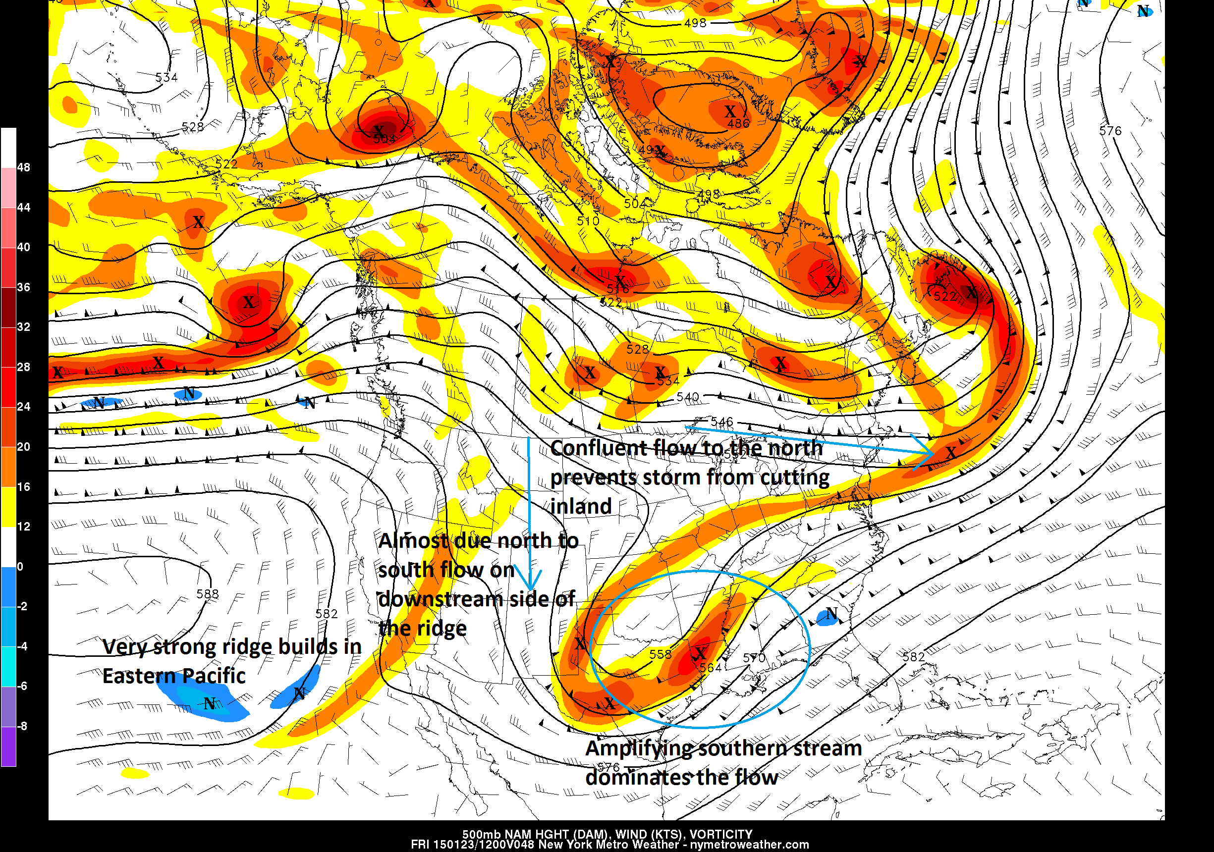
Today’s 12z NAM valid for 4:00am Friday morning shows the pattern becoming more amplified, supporting a large storm system developing.
Now that we know a strong storm is going to attempt to turn up the coast, we can start speculating a bit on the details such as:
1) How far up the coast will the storm go?
2) Where is the rain/snow/mix line going to be?
3) What about heavy banding of snow?
——————-
1) How far up the coast will the storm go?
Initially, there had been a pretty wide split in guidance as far as if the storm was going to be a hit or a miss. However, over the past few days, there has been a definite trend towards the storm climbing up the East Coast. There is going to be a battleground between the amplifying southern stream and still some fast west to east flow in the northern stream that would try to push the storm east. Considering the El Nino characteristics are becoming more evident, it is becoming increasingly likely that the southern stream will be strong enough to track all the way up the coast, and for some northern stream energy to interact.
Wednesday’s NAM Model valid for Friday afternoon shows a strong southern stream impulse turning the jet stream from south to north out ahead of it, and an amplifying pattern to its west. This could be enough to fight off the fast, progressive flow to its north.
The above image looks at 300mb, which is about the jet stream level. We see our powerful storm system taking shape in the Mississippi Valley, and as it amplifies, the jet stream winds turn from south to north out ahead of it. This greatly helps the storm to come up the coast. What had been causing some trends to the east is the west to east flow in the Northeast, which is actually still somewhat evident. However, the southern stream turning, combined with the ridging along the west coast showing a due north to south orientation helps to amplify and align the pattern so that the storm climbs up the coast instead of getting shunted to the east. In fact, if it were not for the west to east flow in the Northeast, the storm would probably be cutting inland, and we would be getting another all-rain event. If that flow in the Northeast were more of a NW to SE flow instead, this storm probably would be missing us to the south.
2) What about the rain/snow/mix line?
This is often one the trickiest questions to answer in meteorology, since a very subtle change in temperature and/or storm track can have a significant impact on temperatures. This storm will not be one of those exceptions. Although we have confluent flow to the north, the airmass will still not be all that cold. But the good news for snow lovers is that during this time of year, you do not need to be anomalously cold to get snow; you just need to be cold enough.
That being said, the rain/snow/mix line has a decent chance of reaching I-95 during for at least a small to medium duration.
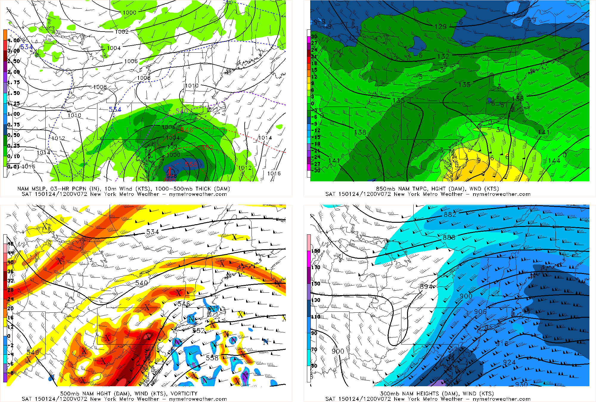
Normally, you want to see a high pressure system in SE Canada, because that helps to funnel in a dense, cold airmass. Instead, there are lower pressures up there as some shortwave energy traverses that region. What that does is help to turn the flow southwesterly before the storm, and bottle up the coldest of the air in Canada. Thus, when the strong storm approaches the area, temperatures are susceptible to rising enough for a period of sleet and rain — particularly just above the ground where wind flow is stronger. How warm this layer gets will determine if the rain/sleet mix only lasts an hour or two, or if it lasts for several hours or more. That is still to be determined. However, notice how on the top-left panel, the storm is strong enough to turn the surface winds northerly. This helps illustrate that a strengthening storm can help turn a stale airmass a bit colder, and turn us all back over to heavy snow, which will be discussed more below.
3) What about heavy bands of snow?
This is the most intriguing part of the storm. Most models show a rapidly deepening cyclone near our latitude, which essentially acts like a vaccuum: as pressure falls, air is allowed to rise like a vacuum, and the atmosphere compensates by funneling in more air at the surface which converges and rises more. And as air rises, lift for precipitation is generated. Today’s European Model deepens the storm to 969mb just SE of Montauk! The storm deepens 44mb in a 24-hour period! And it is actually the pressure falls that matter more for heavy precipitation rather than the pressure itself.
Those maps are not allowed to be distributed, however, so we will use another one of our in-house maps to illustrate this potential.
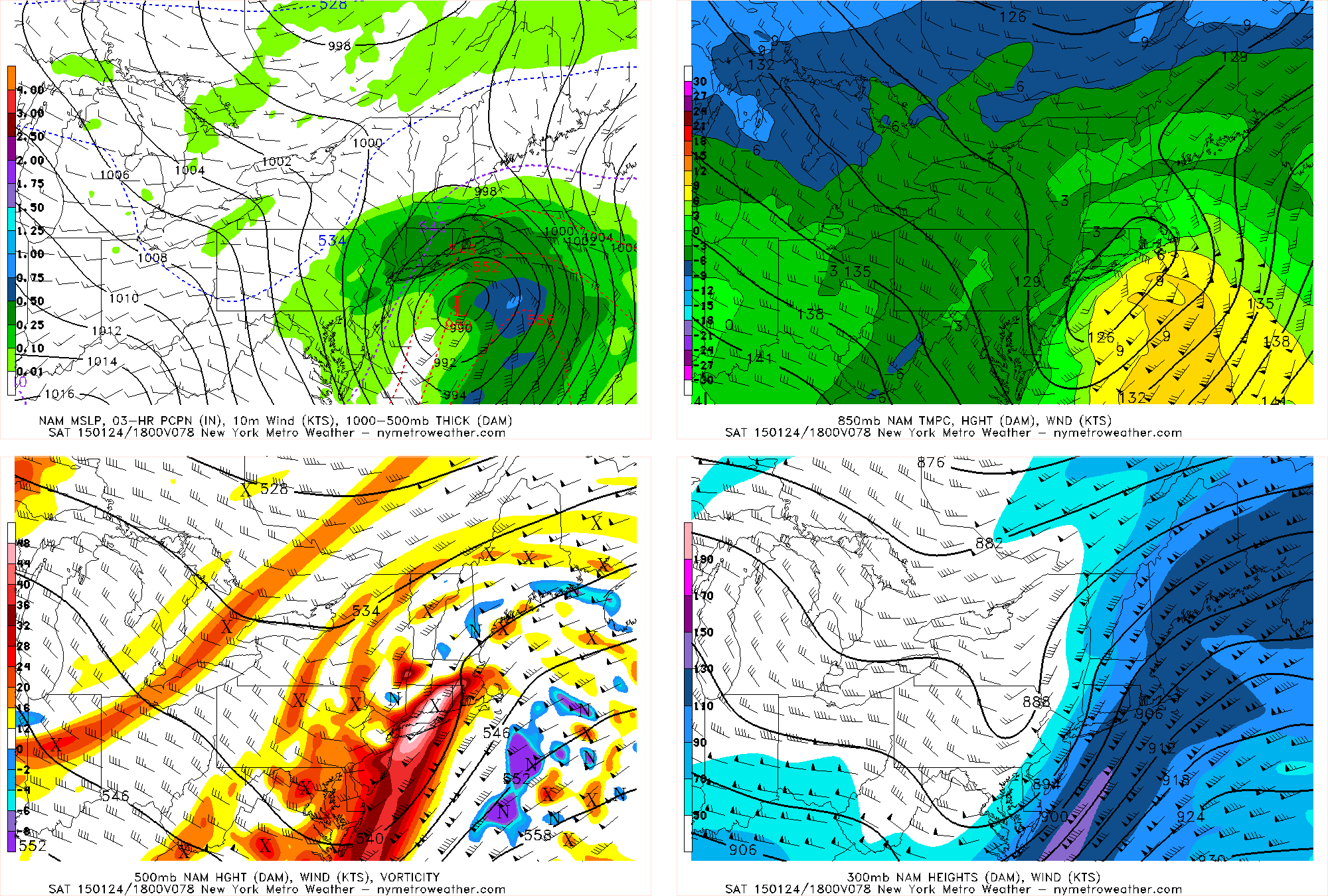
Wednesday’s NAM Model isn’t even the best illustration of this, since it’s still a bit sloppy and doesn’t deepen the storm as much as some other models, but it still deepens enough and still shows some of the necessary processes for heavy snow to use as an example. Notice how on the bottom left panel, you can see that 500mb vorticity is extremely strong, and advecting right into our area: when you have positive vorticity advection, that is a major trigger for strong lifting, which helps to create the pressure falls that lead to more converging surface air, which leads to additional lifting for heavy precipitation development. Additionally, the bottom right panel is the jet stream level, which shows a 130 + knot jet streak just off the coast. We are in the left exit region (left side of where that jet streak ends), which favors a region of upper-level divergence. This means that air at the top of the atmosphere spreads out, and provides an efficient venting vacuum for the air that is rising to be released; that way more converging air at the surface can replace that escaping air and generate more lifting for precipitation. Seeing the left exit region juxtaposed with strong positive vorticity advection is a classic signal for heavy banding of snow. It is one of the reasons why we are seeing such impressive pressure falls on the models.
On the top right, we can see that 850mb temperatures are crashing as the deepening cyclone turns winds to a northerly component, and the dynamics also help to cool the column. Although the air isn’t terribly cold, it would still be cold enough to change areas over to a heavy period of snow, with 1-3″ per hour rates possible.
What could change?
1) Considering the storm is still two to three days away, changes are still likely. One possibility is that the southern stream phasing is just a tad sloppy, allowing energy to run out ahead of the amplifying wave, which would be too early to allow the pattern to truly amplify. This could shunt the storm system out to sea, or provide only a graze. While a graze is possible, an out to sea scenario is very unlikely. This, however, is our biggest concern for this storm system. The potential for the system to be weaker aloft and slower to deepen at the surface would significantly hinder any chance for large snowfall amounts in our area.
2) As alluded to before, the initially stale airmass will be providing some forecasting headaches. If the storm matures just a tad slower, then the stale airmass will become more of a factor in the forecast and create a longer period of rain and sleet, particularly for the coast. This is why we are not yet sold on a snowstorm. That being said, at some point during the storm, the dynamics have a chance to change areas over to heavy snow, and further east areas who were initially warmer could even see more of this heavy banding of snow. It’s quite the tricky forecast.
3) The storm could actually trend more organized, along the lines of the European Model. The European Model verbatim shows a couple of inches of snow, then a few-hour period of rain and sleet, before changing over to several hours of heavy banding of snow, dumping 6-12″+ for a lot of the area. If the mid-level centers of the storm were to mature a few hours earlier, then the winds would turn northerly a bit earlier, allowing for a much more brief period of rain and sleet, and even more heavy snow.
Stay tuned over the next day or so as our forecasters continue to analyze the potential event. We’ll have updates throughout the day on social media and an updated post later today or Friday — including details on another potential winter weather event by Monday. Buckle up!