-2")
Substantial snowfall possible Thursday
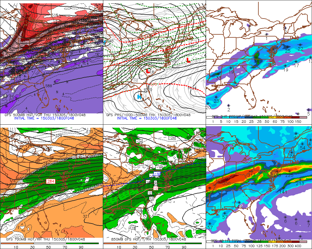
On the heels of a strong southwest flow event which left the area under more snow and sleet this Tuesday into Wednesday morning, a low pressure system is forecast to develop late Wednesday into Thursday and deliver another round of snow. This time, it looks more significant in terms of snowfall accumulations. As a cold front sinks south of the area Wednesday, mid level energy will shift from the Central United States eastward, forcing the development of a low pressure system from the Southeast States into the Mid Atlantic.
A thermal gradient, or baroclinic zone, will be positioned from the Ohio Valley through the Mid Atlantic and Northeast, serving as a highway for the development of precipitation. As the mid level jet dynamics are enhanced Thursday, snow will become more widespread throughout the Mid Atlantic and Northeast United States. On the northern periphery of the forcing for moderate to heavy precipitation, a band of moderate to heavy snow is likely to develop.
Programming Note: We will have a Storm Total Snowfall forecast for release around 11:00pm tonight.
Pinpointing where that band will develop will likely be a major headache for forecasters. Forecast models have been struggling with the intricate details of the threat, including the positioning of the thermal gradient and the northward extent of the heaviest banding. This is problematic as it creates a very uncertain precipitation and snowfall accumulation forecast. The NAM, for example, is farthest north while the GFS and ECMWF have shifted steadily south over the past 24 hours.
As forecasters, this is a good situation to utilize ensemble means. Ensemble means take away, or at the very least mute, the run to run variance of operational forecast models. They help to take away the “outlier” solutions on the either side of the extreme. The GFS and ECMWF ensemble means have both trended southward steadily over the past 24 hours, but not far enough south to take away the potential for significant snowfall.
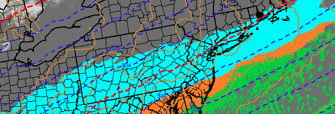
GFS model forecasting heaviest precipitation to remain south of the area Thursday.
When analyzing the mid and upper level atmospheric setup, a few things are important to note. First of all, the surface low is quite a bit south of our area. Forecast models agree that a surface low pressure will develop in the Central Carolinas, and then be shunted eastward off the coast as the mid level height field presses southeastward. This is not a typical setup to bring banding supportive of heavy snow to our area.
On the contrary, very impressive mid level jet dynamics — including an impressive 250mb jet streak — look likely to enhance precipitation farther north. Still, forecast models show a narrow band of enhanced lift pushing northward through the Mid Atlantic to a position near Philadelphia northeastward to Central New Jersey, just south of New York City. This band looks likely to be the focal point for enhanced snowfall amounts of 6 inches or more.
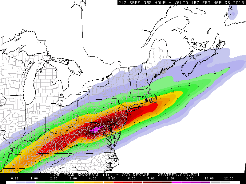
SREF model forecasting 6-7″ of snow from NYC southward on Thursday.
North of this band, lower precipitation rates will result in lesser snowfall amounts despite higher ratios. Sublimation as a result of low level dry air is likely to keep conditions less than favorable for rapid snowfall accumulation. Nevertheless, a light to moderate snowfall can still be expected north of where the band sets up despite the lack of heavy snow.
So, that leaves us with the question: Where will this band set up? Forecast models, as mentioned above, aren’t providing much help. The southward shift in the positioning of this band provides us with increased confidence that it won’t setup north of New York City. Instead, our confidence is rising that this band will set up shop from Southeastern Pennsylvania into Central New Jersey. New York City, not surprisingly, will be just on the fringe of moderate to heavy snow with the potential for a forecast “bust” in either direction.
Snow will be widespread throughout the area on Thursday, regardless of individual nuances, with 3-6″ of snow likely. As mentioned above, confidence is highest in the upper tier of those amounts to the south of New York City, and the lower tier to the north. And, again, a band of 6-9″ amounts will likely setup somewhere from Southeast PA to Central NJ.
Stay tuned for updates on the storm including details and information on banding and snowfall totals as we get additional model data on Wednesday.